Advertising

Home Earth Continents World of Maps Index of Maps by Country


Maps of the World


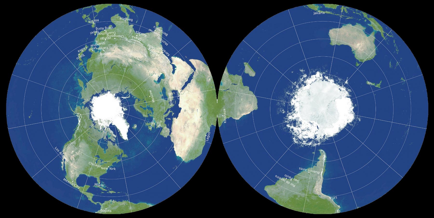
Princeton astrophysicists re-imagine world map
Brave New World
In an attempt to square the circle, scientists came up with a new map of the world. A revolutionary, double-sided disk map that minimizes all six types of map distortions. Great! Terry Pratchett sends his regards.
Image: J. Richard Gott, Robert Vanderbei and David Goldberg. [1]


Political and Administrative Maps of continents, countries and regions, as well as online resources of maps, map collections, reference maps, and world maps.

Maps of the World Maps of Africa Maps of The AmericasMaps of Asia Maps of India Maps of Australia/Oceania Maps of Europe Maps of Antarctica Maps of Oceans and Seas and more...


Definition: Maps are abstract two-dimensional, geometrically more or less accurate representations of a three-dimensional space, like landscapes, oceans, mountains or cities etc. The science and art of map-making is known as cartography.

 
  Online Maps of the World


The map is not the territory.
(Alfred Korzybski)

In the list below, you will find maps and links to maps around the world.  
Additional links to maps of states and countries you will find at Country Maps Index, or within the country profiles:

List of Countries of the World from A to Z


Maps of the World


Continents Map thumb
The Continents (click on the map to enlarge)
Map of World Continents
Continents and regions of the world.

Google Map of Earth
Have a look from space at our planet.

Outline Map of the world
Free blank map of the world for educational purposes.


Novel Coronavirus World Map
World map of countries affected by the novel Coronavirus. (discontinued)


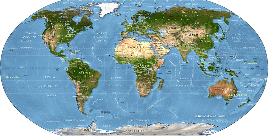
Shaded relief map of the world
Physical Map of the World (click on the map to enlarge)
Political Map of the World
World map showing independent states borders, dependencies or areas of special sovereignty, islands and island groups as well as capital cities.


profile Physical Map of the World
Shaded relief map of the world, showing landmasses, continents, oceans, regions, mountain ranges, islands and island groups as well as extreme points.

Outline map of the world
Outline map of the world's continents and islands.


Maps of Africa


Relief Map of Africa (thumb)
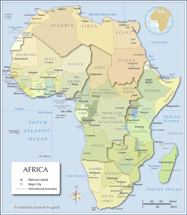
Map of Africa (click on the map to enlarge)
Political Map of Africa
The political map of Africa shows the African states with borders, the capital and major cities.


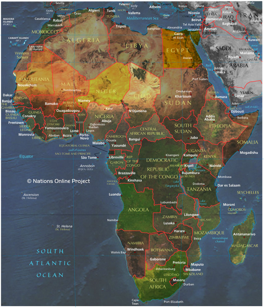
Map of Africa
Map of Africa shows a satellite image of the continent with the African states, capitals, and major cities.


 Map of Northern Africa and the Middle East
Political Map of Northern Africa and the Middle East.

 Map of West Africa
Political Map of West Africa

Historical Map of Africa in 1885
Annotated Map of the Black Continent at the end of the 19th century with brief descriptions of the countries, kingdoms, and regions of that time.


Small Map of the African continent


Political Map of Africa with countries and general regions
Political Map of Africa (click on the map to enlarge)
Algeria Map | Angola Map |
Benin Map | Botswana Map | Burkina Faso Map | Burundi Map |
Cameroon Map | Cape Verde Map | Central African Republic Map | Chad Map | Comoros Map | Congo, Dem. Rep. Map | Congo, Rep. Map | Côte d'Ivoire (Ivory Coast) Map |
Djibouti Map |
Egypt Map | Equatorial Guinea Map | Eritrea Map | Ethiopia Map |
Gabon Map | Ghana Map | Guinea Map | Guinea-Bissau Map |
Kenya Map |
Liberia Map | Libya Map |
Madagascar Map | Malawi Map | Mali Map | Mauritania Map | Mauritius Map | Morocco Map | Mozambique Map |
Namibia Map | Niger Map | Nigeria Map |
Réunion Map | Rwanda Map |
Senegal Map | Seychelles Map | Sierra Leone Map | Somalia Map | South Africa Map | Sudan Map | Swaziland Map |
Tanzania Map | Togo Map | Tunisia Map |
Uganda Map |
Zambia Map | Zimbabwe Map


The Continent of Africa with maps of African countries
List of detailed Maps of almost all African Countries.

External Links:
Maps of Africa
by the Perry-Castañeda Library Map Collection.

Historical Maps of Africa
Perry-Castañeda Library Map Collection.

Maps of North America, South America and Central America and the Caribbean


Map of North America including Greenland
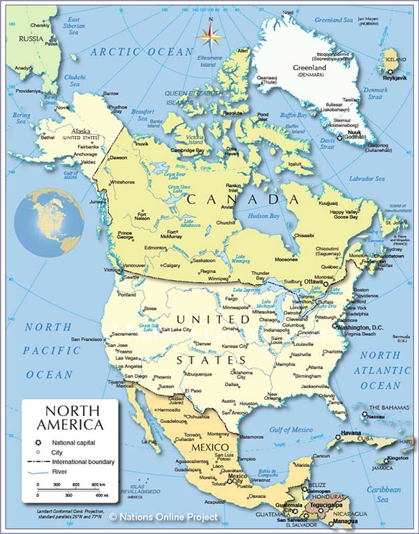
Map of North America (click on the map to enlarge)
Maps of North America
Map of North America (855px)
Reference Map of North America.
Map of North America (1200px)
Clickable political map of North America.
profile Shaded Relief Map of North America
Physical North America Map


Maps of South America
A political and a topographical map of South America.

Map of the Caribbean
Reference Map of the Caribbean.

Map of Central America and the Caribbean
Clickable political map of Central America and the Caribbean.


External Link
Maps of the Americas
By PCL Map Collection (public domain.)

Maps of Canada

 Administrative Map of Canada
The map shows Canada's ten provinces and three territories.

External Link
The National Atlas of Canada
Information on the geography of Canada.


Maps of the United States

United States Map
Map of the USA (click on the map to enlarge)
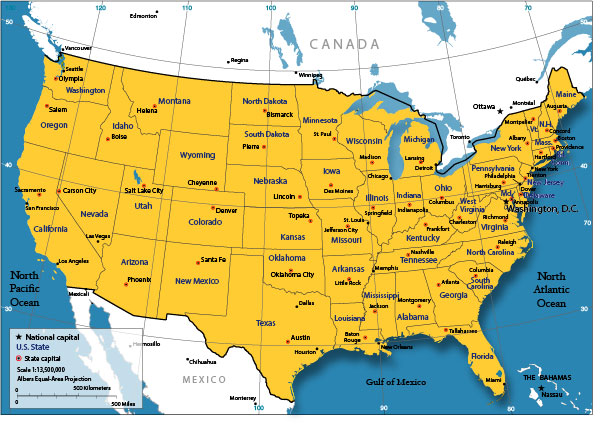
Map of the United States
OWNO's free Map of the United States.

Blank Map of the United States
Free map with national and states borders.

Map of United States Time Zones
Time Zones of the United States and the actual time in the different time zones.

Maps of the 50 U.S. States
From Alabama to Wyoming - Index of maps of all US states.


US State Maps
Maps of all fifty US states.

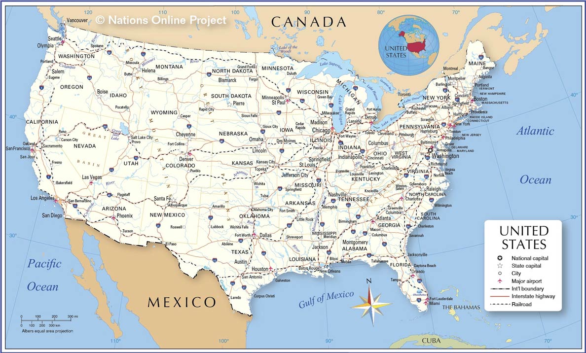
General United States Map
General Map of the USA (click on the map to enlarge)
Alabama Map | Alaska Map | Arizona Map | Arkansas Map | California Map | Colorado Map | Connecticut Map | Delaware Map | Florida Map | Georgia Map | Hawaii Map | Idaho Map | Illinois Map | Indiana Map | Iowa Map | Kansas Map | Kentucky Map | Louisiana Map | Maine Map | Maryland Map | Massachusetts Map | Michigan Map | Minnesota Map | Mississippi Map | Missouri Map | Montana Map | Nebraska Map | Nevada Map | New Hampshire Map | New Jersey Map | New Mexico Map | New York Map | North Carolina Map | North Dakota Map | Ohio Map | Oklahoma Map | Oregon Map | Pennsylvania Map | Rhode Island Map | South Carolina Map | South Dakota Map | Tennessee Map | Texas Map | Utah Map | Vermont Map | Virginia Map | Washington Map | West Virginia Map | Wisconsin Map | Wyoming Map

External Links:
State Map Sites (U.S.)
The Perry-Castañeda Library Map Collection.
Relief maps of the United States
The relief maps use false-color 3-D shading to show changes in altitude.

Historical Maps of the Americas
Perry-Castañeda Library Map Collection.


Maps of Asia


Reference maps, political maps and administrative maps of countries in Asia.

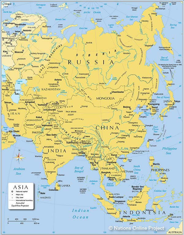
Asia Map
Map of Asia (click on the map to enlarge)
profile Reference Map of Asia
Political Map of Asia.

profile Map of Central Asia
Map of Central Asia region.

profile Map of Kashmir
Map of Kashmir region.

profile Political Map of Russia
Political Map of Russia.

profile Political Map of European Russia
Political Map of Western Russia.

Map of Southeast Asia
Map of the Southeast Asia region.

profile Map of Western Asia
Map of Western Asia and the Middle East region.

profile Map of Countries of Western Asia
Political Map of Countries of Western Asia and the Middle East region.


Maps of countries in Asia and the Middle East


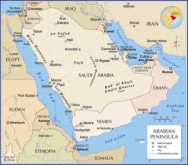
Map of the Arabian Peninsula
Arabian Peninsula Map (click the map to enlarge)
 
Maps of countries in Western Asia

Armenia Map | Azerbaijan Map | Cyprus Map | Georgia Map | Map of Turkey |

Maps of countries in the Middle East

Bahrain Map | Egypt Map | Iran Map | Iraq Map | Israel Map | Jordan Map | Kuwait Map | Lebanon Map | Oman Map | Palestine Territories Map | Qatar Map | Saudi Arabia Map | Syria MapUnited Arab Emirates Map | Yemen Map

Maps of countries in Central Asia

Afghanistan Map | Kazakhstan Map | Kyrgyzstan Map | Tajikistan Map | Turkmenistan Map | Uzbekistan Map

Maps of countries in East Asia

Political Map of China | Administrative Map of China | Japan Map | North Korea Map | South Korea Map | Mongolia Map | Taiwan Map

Maps of countries in South Asia

Bangladesh Map | Bhutan Map | India Map | Maldives Map | Nepal Map | Pakistan Map | Sri Lanka Map |

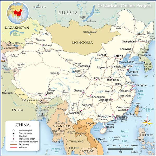
Political Map of China
Political Map of China (click on the map to enlarge)
Maps of countries in Southeast Asia

Cambodia Map | Indonesia Map | Laos Map | Malaysia Map | Myanmar Map | Philippines Map | Singapore Map | Thailand Map | Vietnam Map


profile Maps of Asia
Political maps of almost all countries in Asia.

profile Map of the Arabian Peninsula
Map of the Arabian Peninsula in the Middle East region.

profile Map of the Sinai Peninsula
Map of Sinai in the Middle East region.

profile Map of the Caspian Sea
Map of the Caspian Sea region.

Map of South China Sea
Political Map of South China Sea.

External Links:
Maps of Asia
Perry-Castañeda Library Map Collection.

Map of the Commonwealth of Independent States (CIS)
The free association of sovereign states formed in 1991 and comprising Russia and the republics of Armenia, Azerbaijan, Belarus, Georgia, Kazakstan, Kyrgyzstan, Moldova, Tajikistan, Turkmenistan, Ukraine and Uzbekistan, all formerly part of the Soviet Union.

Maps of the Middle East
Perry-Castañeda Library Map Collection Middle East Maps.

Historical Maps of Asia
Perry-Castañeda Library Map Collection of Historical Maps of Asia.

Maps of India


Map of India's States
India Map
Administrative Map of India
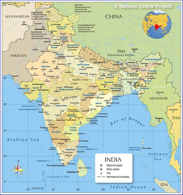
Map of India (click on the map to enlarge)
Map of India
Map of India with States and Union Territories and their Capitals.

Administrative Map of India
Administrative Map of India showing all 29 States, Union Territories, and major cities.


States of India:
Andhra Pradesh, Arunachal Pradesh, Assam,
Bihar, Chhattisgarh, Goa, Gujarat,
Haryana, Himachal Pradesh,
Jammu and Kashmir, Jharkhand,
Karnataka, Kerala,
Madhya Pradesh, Maharashtra, Manipur, Meghalaya, Mizoram,
Nagaland, Orissa, Punjab, Rajasthan, Sikkim,
Tamil Nadu, Tripura,
Uttaranchal, Uttar Pradesh, West Bengal

Union Territories:
Andaman and Nicobar Islands, Chandigarh,
Dadra and Nagar Haveli, Daman and Diu,
Lakshadweep, Puducherry

profile Map of Kashmir
Map of the Kashmir region, partly claimed by India, Pakistan and China.


Maps of Australia/Oceania


Map of Australia/Oceania
Reference Map of the Australia/Oceania continent.

Administrative Map of Australia
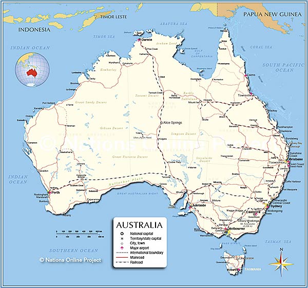
Map showing continental Australia with state borders and capital cities.

Australia Map
Political Map of Australia.

Detailed Australia Map
Map showing mainland Australia with international borders, state boundaries, the national capital Canberra, state capitals, major cities and towns, main roads, railroads and international airports.

New Zealand Map
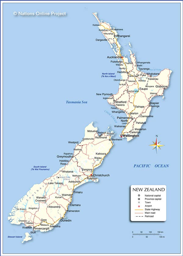
Political Map of New Zealand.

New Caledonia Map
Map of New Caledonia (France)

Papua New Guinea Map
Political Map of Papua New Guinea.

Hawaii Map
Map of Hawaii

Samoa Map
Map of (Western) Samoa.

American Samoa Tutuila Map
Tutuila Island Map.

Tonga Map
Map of the Kingdom of Tonga.

Guam Map
Map of Guam


Map of Melanesia
Map of the Island States and Territories of Melanesia.
Map of Micronesia
Map of the Island States and Territories of Micronesia.
Map of Polynesia
Map of the Countries and Territories in Polynesia, the island states in the eastern part of Oceania.


External Links to Maps of Australia/Oceania
Geoscience Australia
Online resource for Australia-related facts and maps.

Maps of Australia and the Pacific
Perry-Castañeda Library Map Collection.

Historical Maps of Australia and the Pacific
Perry-Castañeda Library Map Collection.


Maps of Europe


Europe Map showing European countries
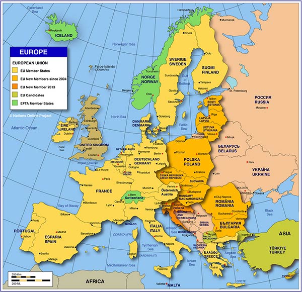
Map of Europe (click on the map to enlarge)
Map of Europe
Political map of Europe with member states of the European Union and EFTA, showing major cities and capitals.

Map of the Mediterranean Region
Political Map of Mediterranean Region, the Mediterranean Sea, and the Black Sea Region.

Map of the Balkan Peninsula
Political Map of the Balkans.

Map of the Baltic States
Political Map of the Baltic Countries.

Map of the Baltic Sea
Map of the Baltic Sea and bordering countries.

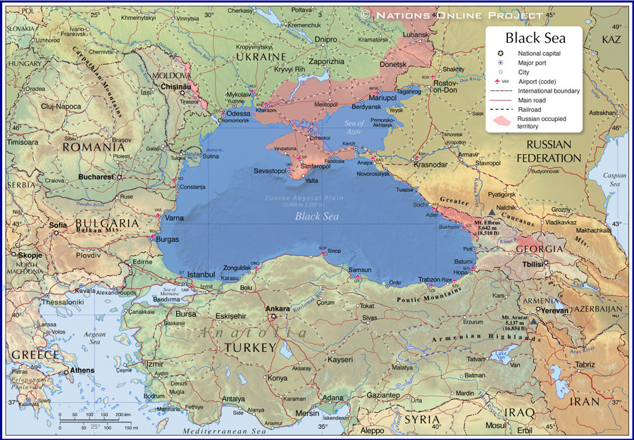
Map of the Black Sea
Political Map of the Black Sea.

Map of Central Europe
Political Map of Central and Eastern Europe.

Political Map of the Black Sea
Political Map of the Black Sea (click on the map to enlarge)

 
Map of European Russia
Political Map of the European part of Russia.

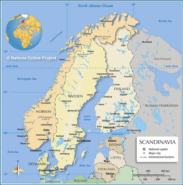
Map of Scandinavia
Political Map of Fennoscandia and Scandinavia (Denmark, Norway, Sweden, and Finland).

Topographic Map of the Iberian Peninsula
Shaded relief map of the Iberian Peninsula.


Maps of European Countries:

Scandinavia Map showing Scandinavian countries
Map of Scandinavia (click on the map to enlarge)
Albania | Austria | Belarus | Belgium | Bosnia and Herzegovina | Bulgaria | Croatia | Cyprus | Czech Republic | Denmark | Estonia | Faroe Islands | Finland | France Germany | Greece | Greenland | Hungary | Iceland | Ireland | Italy | Latvia | Lithuania | Luxembourg | Macedonia | Moldova | Montenegro | Netherlands | Norway | Poland | Portugal | Romania | Russia | Serbia | Slovakia | Slovenia | Spain | Sweden | Switzerland | Turkey | Ukraine | United Kingdom | Vatican City


Index of Google Maps of Europe
Index of searchable Maps of Countries and Capital Cities of Europe.

External links to maps of Europe:
Maps of Europe
Perry-Castañeda Library Map Collection.

Historical Maps of Europe
Perry-Castañeda Library Map Collection.


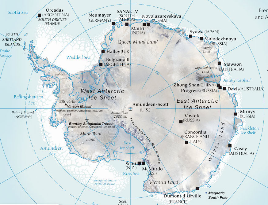
Physical Map of Antarctica
Map of Antarctica (click on the map to enlarge)

Maps of Antarctica


Map of Antarctica
Physical Map of Antarctica.


Maps of Oceans and Seas


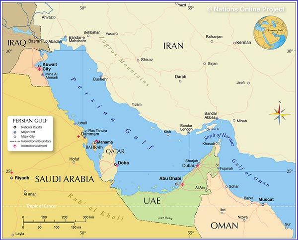
Map of the Persian Gulf and the Gulf States.
Map of the Persian Gulf (click on the map to enlarge)
Map of the Baltic Sea
Map of the Baltic Sea and bordering countries.


Map of the Black Sea
Political Map of the Black Sea.


Map of the Caspian Sea
The map shows the Caspian Sea and surrounding countries.


Map of the Mediterranean Sea
Map of the Mediterranean Sea with surrounding countries.


Map of the Persian Gulf
Map of the Persian Gulf and the Gulf States.


Map of the Red Sea
Map of the Red Sea with the Gulf of Suez, the Gulf of Aqaba and the surrounding countries.


Map of the South China Sea
The map shows the South China Sea with bordering countries.


NOAA Bathymetry - Maps of the World Oceans
Solar System
Image: NASA

Planetary Maps
Solar System
The Planets in our Solar System from Mercury, Venus, Earth, Mars, Jupiter, Saturn, Uranus, Neptune, to Pluto, the Sun, Asteroids and Stars.


Worldmap of Press Freedom
World Map of Press Freedom
Map of the worldwide situation of freedom of the press.


Map indexes, map directories and other cartographic-related sites.


web culture Perry-Castañeda Library Map Collection
Online Maps, many of them in the public domain.

The Shaded Relief Map of the World
ArcGIS' Shaded Relief Map of the World.

Equal Earth
Equal Earth Map Projection (Tom Patterson).

Relief Map
Web Mercator Relief map of the world.

World City Maps
A collection of maps in the public domain for cities around the world.

Maps of World Regions
CIA World Factbook - maps of all world regions in the public domain.

EarthExplorer
The EarthExplorer (EE) user interface is an online search, discovery, and map ordering tool developed by the United States Geological Survey (USGS).

NASA - The Earth Observatory
Various maps of the Earth from cloud fraction to accelerating sea level rise to vegetation.

Visible Earth
Visible Earth is part of the EOS Project Science Office at NASA Goddard Space Flight Center.


Dymaxion Map-Fuller Projection
"The flat Earth"
The Dymaxion Map - Fuller Projection, the only flat map of the entire surface of the earth that reveals our planet as it really is, an island in one ocean without any visible distortion of the relative shapes and sizes of the land areas and without splitting any continents.


GTOPO30 Global Topographic Data
World map, a global digital elevation model (DEM) with a horizontal grid spacing of 30 arc seconds (approximately 1 kilometer).

NOAA Bathymetry Data Viewer
NOOA Bathymetry and Global Relief maps.

Relief Globe
Relief maps of planet Earth show surface and undersea topography.