Advertising

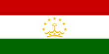
Tajikistan Flag detail

Map of Tajikistan

Lake Yashilkul, autonomous province of Gorno-Badakhshan, Tajikistan
A sunny day at Lake Yashilkul, an alpine freshwater lake in the autonomous Tajik province of Gorno-Badakhshan. The lake is located in southeastern Tajikistan in the Pamir Mountains at an altitude of 3,800 meters.
Image: Michael Bamford

About Tajikistan


Tajikistan Flag
The map shows Tajikistan, a landlocked republic in Central Asia. The country lies north of Afghanistan, southeast of Uzbekistan, and south of Kyrgyzstan, and it borders China to the east.

With an area of 143,100 km², the country is about less than half the size of Italy, or slightly smaller than the U.S. state of Wisconsin.

Tajikistan has a population of 10.5 million people (in 2025). The main ethnic groups are Tajiks (86%) and Uzbeks (11%). Spoken languages are Tajik (a variety of Persian spoken in Tajikistan and Uzbekistan by Tajiks). Russian is the official interethnic language. Tajikistan is a predominantly Sunni Muslim country; over 90% of the population identifies itself as Muslims. Capital and largest city is Dushanbe (Душанбе).


Map of Tajikistan

Political Map of Tajikistan

The map shows Tajikistan and surrounding countries with international borders, the national capital Dushanbe, administrative capitals, major cities, main roads, railroads, major airports and important geographcal features.

You are free to use the above map for educational and similar purposes; if publishing, please credit Nations Online Project as the source.


More about Tajikistan


Pamir mountain range, Gorno-Badakhshan Autonomous Region, eastern Tajikistan
The Gorno-Badakhshan Autonomous Region in eastern Tajikistan. The Pamir mountain range in the background.
Photo: Ninara


Tajikistan, officially the Republic of Tajikistan, is a landlocked country in Central Asia.

The former Soviet Republic is known for its dramatic mountainous landscapes and remote high-altitude terrain. Mountains cover over 90% of Tajikistan. The Pamir and Alay Mountains dominate the landscape of the country. These mountain ranges are among the highest and most rugged regions in the world.

Towering Ismoil Somoni Peak, once known as Communism Peak and Stalin Peak, reaches 7,495 m. Fun fact: it was the highest point in the former Soviet Union.

Tajikistan lies in a seismically active zone. Its landscape offers deep valleys, narrow gorges, and glacial rivers. Among them are the Vakhsh and Panj rivers, both major tributaries of the Amu Darya.

In the west, the multi-ethnic Fergana Valley is shared by Uzbekistan, Kyrgyzstan, and northern Tajikistan.

The eastern part of Tajikistan is known as the Badakhshan Mountainous Autonomous Region, a vast, sparsely populated plateau with a raw beauty and a harsh climate.

Tajikistan is, together with Bhutan, Kyrgyzstan, and Lesotho, among the most mountainous countries in the world; its rugged geography has played a key role in its history and culture.


Major Rivers of Tajikistan
Lake Karakul with the eastern Pamir mountain range in the background.
The Panj River, the source of the Amu Darya River, forms much of the border with Afghanistan.
Photo: Ninara


Lakes of Tajikistan

Lake Karakul with the eastern Pamir mountain range in the background.
Lake Karakul, with the eastern Pamir Mountain Range in the background.
Photo: Steynard


Mountains

View over Tajikistan Mountains
A breathtaking view of the snow-capped mountains of the Trans-Alay Range from Lenin Peak. The country's second highest mountain, also known as Ibn Sina Peak, is located on the Tajik-Kyrgyz border.
Photo: twiga269 EVEREST

The Seven Thousanders of Tajikistan.
Tajikistan features the Pamir Mountains, also known as the "Roof of the World." The country is home to some of the tallest mountains in the world outside the Himalayas.


Strategic Passes and Borders

A herd of Yaks in the mountains of Tajikistan.
A herd of yaks in the mountains of Tajikistan. Yaks are a vital resource for high-altitude herders, serving as a primary source of income and food, especially during winter months.
Photo: Sergio Agostinelli


Tajik Cities
Palace of the Nation, the official residence of the President of Tajikistan, in Dushanbe, Tajikistan
Palace of the Nation, the official residence of the President of Tajikistan in Dushanbe, the capital of Tajikistan.
Photo: Philipp Winter


Tajikistan's largest cities

16th century Kok-Gumbaz (Abdulatif Sultan) Madrasa in Istaravshan, Tajikistan.
16th-century Kok-Gumbaz (Abdulatif Sultan) Madrasa in Istaravshan, Tajikistan.
Photo: Richard Mortel


Tajikistan Cities and Towns

Depicted on the map are the location of the following Tajik cities and towns:

Ayni, Buved, Childara, Chkalovsk, Dangara, Dashtishur, Dushanbe, Dzhartyrabot, Garm, Hisor (Gissar), Isfara, Ishkashim, Jirgatal, Kalaikhum, Kalininabad, Kalot, Kanibadam, Kargovad, Kazidi, Khorugh, Khovaling, Khujand, Kofarnikhon, Kolkhozabad, Komsomolabad, Kudara, Kulob (Kulyab), Lairon, Moskovskiy, Murgab, Navabad, Nizhniy Panj, Nurek, Obigarm, Panj, Panjakent, Qurghonteppa (Kurgan-Tyube), Rangkul, Rushan, Sayod, Shaartuz, Shahriostan, Shaymak, Shuroabad, Sicharog, Taboshar, Tavildara, Tursunzade, Uroteppa, Vanj, Vir, Vrang, and Wakhion.


Advertisements:


More about Tajikistan

Country:
Tajikistan Country Profile

Continent:
Map of Central Asia
Map of Southwestern Asia
Reference Map of Southwestern Asia and the Middle East. 
 

Weather Conditions Dushanbe:

DUSHANBE WEATHER


Advertisements:


Other Countries in Central Asia:
AFG Afghanistan, (capital: Kabul), KAZ Kazakhstan (capital: Astana), KGZ Kyrgyzstan (capital: Bishkek), TKM Turkmenistan (capital: Ashgabat), and UZB Uzbekistan (capital: Tashkent)

Maps of Countries in Central Asia:
Afghanistan Map | Kazakhstan Map | Kyrgyzstan Map | Turkmenistan Map | Uzbekistan Map