
|
Home |
|
|
|
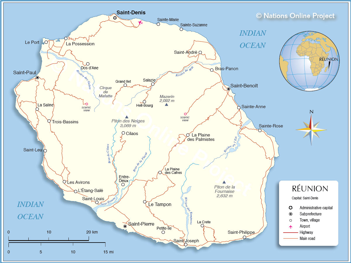
___ Map of Réunion |
|
| Map is showing Reunion an island in the Southern Hemisphere in the Indian Ocean, 740 km (460 mi) east off the coast of Madagascar. Reunion belongs to the Mascarene islands, an archipelago of three main islands of volcanic origin, the others being Mauritius and Rodrigues. Reunion is 70.5 km long (43.8 mi, from north west to south east) and about 50 km (31 mi) wide. Reunion's landscape is mountainous and dominated by Piton de la Fournaise, currently one of the most active volcanoes in the world, and Piton des Neiges, the highest point on the island, a massive now dormant 3,069 m high shield volcano, the origin of the island's creation. The island formerly known as Île Bourbon, is a French overseas department with a population of 845,000 inhabitants (in 2014). Reunion is divided into four arrondissements, 49 cantons and 24 communes (municipalities). Administrative capital is Saint-Denis. Spoken languages are French (official) and Réunion Creole. |
 Bookmark/share this page |
 One World - Nations Online All Countries of the World |
|
|
||
 Map of Reunion | |||||||
|
Cities and Communes in Reunion: Map shows the location of following cities and communes in Reunion: The 4 arrondissements of the Réunion department are:
Communes: Bras-Panon, Cilaos, Entre-Deux, L'Étang-Salé, La Plaine-des-Palmistes, La Possession, Le Port, Le Tampon, Les Avirons, Petite-Île, Saint-André, Saint-Benoît, Saint-Denis, Saint-Joseph, Saint-Leu, Saint-Louis, Saint-Paul, Saint-Philippe, Saint-Pierre, Sainte-Marie, Sainte-Rose, Sainte-Suzanne, Salazie, and Trois-Bassins. |
More about Reunion: Cities: Country: Searchable map/satellite view of Reunion. Continent: |
Weather Conditions Réunion:
|
Explore More:
Related Consumer Information:
|
||||
Maps of other Countries in East Africa Burundi Map | Comoros Map | Djibouti Map | Eritrea Map | Ethiopia Map | Kenya Map Madagascar Map | Malawi Map | Mozambique Map | Rwanda Map | Somalia Map | Tanzania Map Uganda Map | Zambia Map | Zimbabwe Map Interactive Maps of other Countries in East Africa Burundi Interactive Map | Comoros Interactive Map | Djibouti Interactive Map | Eritrea Interactive Map Ethiopia Interactive Map | Kenya Interactive Map | Madagascar Interactive Map | Malawi Interactive Map Mauritius Interactive Map | Mozambique Interactive Map | Rwanda Interactive Map Seychelles Interactive Map | Somalia Interactive Map | Tanzania Interactive Map | Uganda Interactive Map Zambia Interactive Map | Zimbabwe Interactive Map Major Cities in East Africa Addis Ababa, Antananarivo, Asmara, Bujumbura, Dar es Salaam, Djibouti, Dodoma, Harare, Kampala, Kigali, Lilongwe, Lusaka, Maputo, Moroni, Mogadishu, Nairobi, Port Louis, Victoria, Zanzibar |
|||||||
One World - Nations Online .:. let's care for this planet Every nation is responsible for the current state of our world. |
| Site Map
| Information Sources | Disclaimer: Privacy Policy, etc. Contact: [email protected] | Copyright © 1998-2021 :: nationsonline.org |
