
|
|
___ Political Map of Senegal |
|
Senegal is a country on the coast of West Africa, bordering the North Atlantic Ocean in west. It is bordered by The Gambia, Guinea, Guinea-Bissau, Mali, and Mauritania, and it shares a maritime borders with Cape Verde. With an area of 196,722 km² Senegal is about 1.5 times the size of Greece or slightly smaller than the U.S. state of South Dakota. Senegal has a tropical hot and humid climate, it has a rainy season from May to November with strong southeast winds. The dry season from December to April is dominated by the Harmattan, a hot, dry trade wind in West Africa. Senegal's terrain is generally low with rolling plains rising to foothills in southeast, its highest point with 581 m, is an unnamed elevation in the south eastern corner of the country, near the city of Kédougou. The country has a population of about 14.8 million people (in 2016); capital and largest city is Dakar. Spoken languages are French (official), Wolof, and other West African languages. Map is showing Senegal and surrounding countries with international borders, the national capital Dakar, region and district capitals, cities, towns, major rivers, main roads, railroads and major airports. |
 Bookmark/share this page |
 One World - Nations Online All Countries of the World |
|
|
||
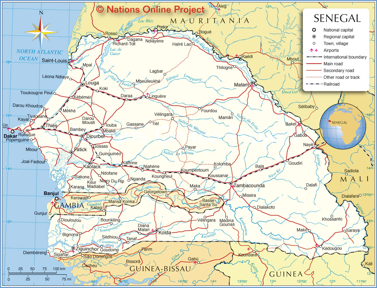 Political Map of Senegal Map based on a UN map. Source: UN Cartographic Section | |||||||
| Cities and towns in Senegal Map shows the location of following cities and villages in Senegal (Region capitals in bold) Bakel, Bala, Bambey, Bignona, Bounkiling, Dagana, Dakar, Dalafi, Daraa, Darou Mousti, Darou Khoudos, Dialakoto, Diana Malari, Diembéreng, Diouloulou, Diourbel, Fatick, Fourdou, Gabou, Gassane, Gossas, Goudiri, Goudomp, Guinguinéo, Haïré Lao, Joal-Fadiout, Kaffrine, Kaolack, Karang, Kayar, Keur Madiabel, Kébémèr, Kédougou, Khossanto, Koki, Kolda, Kolomba, Koumpentoum, Koungheul, Koussanar, Lagbar, Léona Ndiaye, Linguère, Louga, Maka, Mako, Mamâri, Matam, Mbaké, Mbeulleukhé, Mbour, Médina Gounas, Mékhé, Missira, Mpal, Nayé, Ndiayène, Ndofane, Nganda, Niahène, Nioro Du Rip, Payar, Podor, Popenguine, Richard-Toll, Rufisque, Saint-Louis, Sakone, Saraya, Sédhiou, Siganar, Tambacounda, Tanaf, Thiès, Thilogne, Tièl, Tioukougne Peul, Tivaouane, Touba, Vélingara, Vélingara, and Ziguinchor. | More about Senegal: Cities: Country: Continent: |
Dakar Current Weather Conditions
|
Related Consumer Information: | ||||
Political Maps of Countries in West Africa: Benin Map | Burkina Faso Map | Cape Verde Map | Côte d'Ivoire Map | Ghana Map | Guinea Map | Guinea-Bissau Map Liberia Map | Mali Map | Mauritania Map | Niger Map | Nigeria Map | Sierra Leone Map | Togo Map | |||||||
One World - Nations Online .:. let's care for this planet Every nation is responsible for the current state of our world. |
| Site Map
| Information Sources | Disclaimer: Privacy Policy, etc. Contact: [email protected] | Copyright © 1998-2021 :: nationsonline.org |
