
| Home |
|
|
|
___ Political Map of Austria | |
About Austria |
|
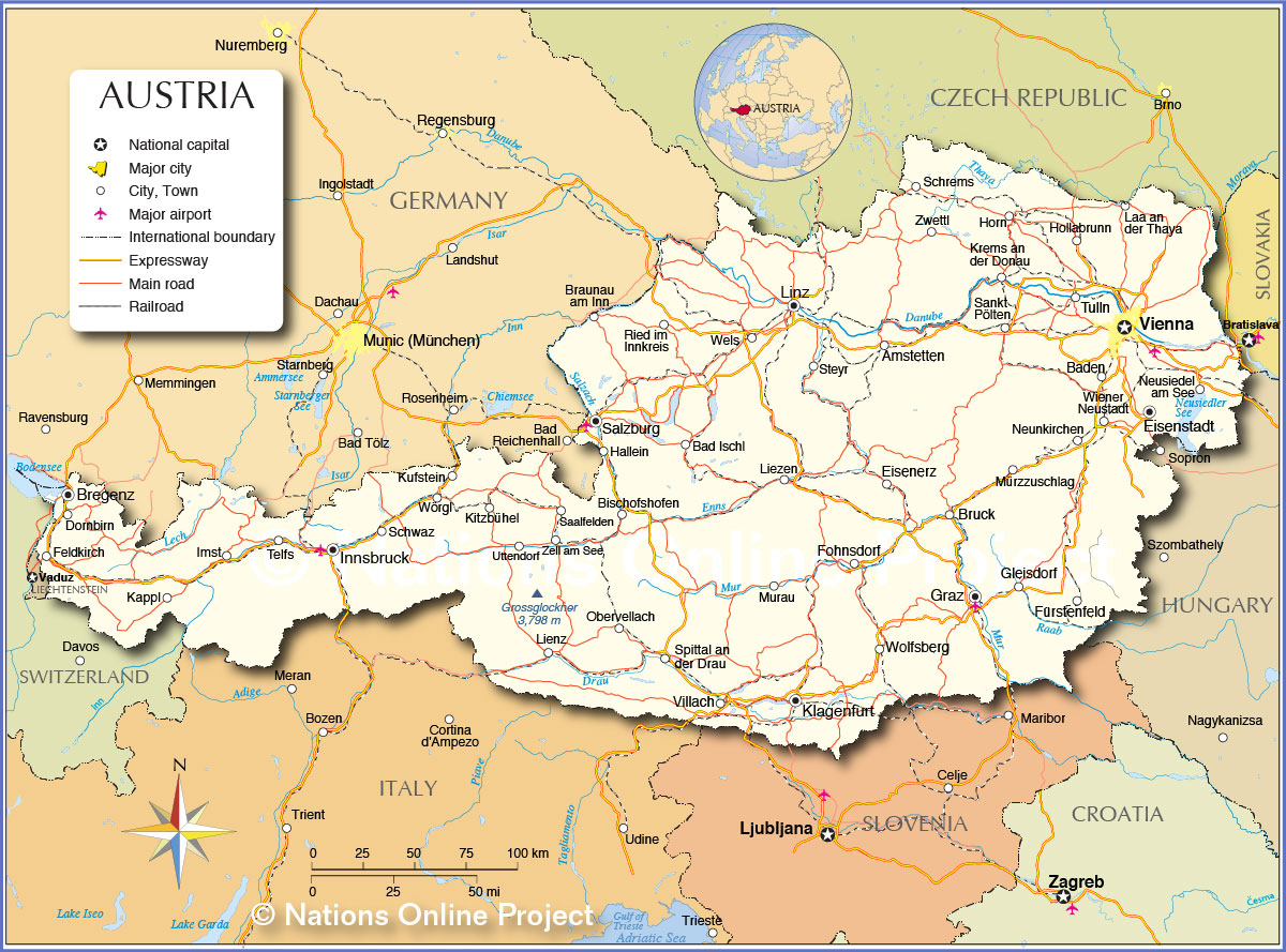
| Map is showing Austria, officially the Republic of Austria, a landlocked country in East Central Europe that borders the Czech Republic, Germany, Hungary, Italy, Liechtenstein, Slovakia, Slovenia, and Switzerland. With an area of 83,871 km² Austria is compared somewhat smaller than Portugal (92,090 km²), or slightly smaller than the U.S. state of Maine. The country is mostly dominated in the west and south by mountains (the Alps), the Central Eastern Alps, the Northern Limestone Alps and the Southern Limestone Alps are all partly in Austria. About a quarter of the country along the eastern and northern margins of the Alps can be considered low lying or gently sloping. Austria's highest point is Grossglockner mountain with a height of 3,798 m (12,460 ft.). The Pasterze glacier, Austria's most extended glacier covers parts of the Grossglockner's eastern slope. The major rivers north of the watershed of the Austrian Alps are the Inn, the Salzach, and the Enns, they are tributaries of the Danube. The rivers south of the watershed are the Gail and Drau rivers in Carinthia and the Mürz and Mur rivers. Austria has a population of 8,593,800 people (2015), capital and largest city is Vienna, with a population of 1.8 million people. Spoken language is Austrian German (official), spoken regional languages are Croatian, Hungarian, and Slovene. Depicted on the map is Austria with surrounding countries, international borders, major cities, main roads, railroads, and major airports, Vienna International Airport (in German: Flughafen Wien; IATA Code: VIE) is the primary international airport in Austria). |
 Bookmark/share this page |
 One World - Nations Online all countries of the world |
|
|
||
 Political Map of Austria |
| Cities and Towns in Austria: The map shows the location of following Austriaian cities: Largest Cities (pop. 2013) after Vienna are: Graz (300,000), Austria's second-largest city and the capital of Styria (Steiermark), known as a student city with six universities; Linz (190,000), founded by the Romans, today one of the main economic centers of Austria and the capital of Upper Austria (Oberösterreich), Salzburg (150,000), capital of the federal state of Salzburg, famous for its baroque architecture of the "Old Town" and as the birthplace of composer Wolfgang Amadeus Mozart; Innsbruck (117,000), capital of Tyrol (Tirol) and the cultural and economic center of western Austria, it is an internationally renowned winter sports center; Klagenfurt (90,000), capital of Carinthia (Kärnten), one of the nine Austrian states. Other cities and towns: Amstetten, Bad Ischl, Baden, Bischofshofen, Braunau am Inn, Bregenz, Bruck, Dornbirn, Eisenerz, Eisenstadt, Feldkirch, Fohnsdorf, Fürstenfeld, Gleisdorf, Hallein, Hollabrunn, Horn, Imst, Kappl, Kitzbühel, Krems an der Donau, Kufstein, Laa an der Thaya, Lienz, Liezen, Murau, Mürzzuschlag, Neunkirchen, Neusiedel am See, Obervellach, Ried im Innkreis, Saalfelden, Sankt Pölten, Schrems, Schwaz, Spittal an der Drau, Steyr, Telfs, Tulln, Uttendorf, Vienna, Villach, Wels, Wiener Neustadt, Wolfsberg, Wörgl, Zell am See, and Zwettl. |
More about Austria: Landmarks: Cities: Country: Continent: |
Vienna Current Weather Conditions
|
Explore more:
Related Consumer Information:
|
||||
Major Cities in Western Europe Amsterdam, Berlin, Bern, Cologne, Brussels, Frankfurt, Hamburg, Luxembourg (City), Monaco, Munich (München), Nice, Paris, Rotterdam, The Hague, Vaduz, Zurich Searchable Maps of other Countries in Western Europe: Austria | Belgium | France | Germany | Liechtenstein | Monaco | Luxembourg | Netherlands | Switzerland Maps of Other Countries in Western Europe: Belgium Map, France Map, Germany Map, Netherlands Map, Switzerland Map |
One World - Nations Online .:. let's care for this planet Every nation is responsible for the current state of our world. |
| Site Map
| Information Sources | Disclaimer: Privacy Policy, etc. Contact: [email protected] | Copyright © 1998-2021 :: nationsonline.org |
