Advertising

North Korea Flag detail
Home Earth Continents Asia North Korea Country Profile Map of North Korea

Maps Index


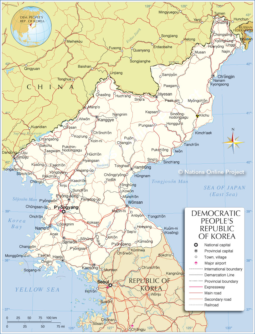
Map of North Korea

Panoramic view of Pyongyang from Juche Tower.
Panoramic view of Pyongyang from Juche Tower, with the gushing Juche Tower fountain in the Taedong River in the foreground. The pyramid-shaped skyscraper in the background is the unfinished 330 m tall Ryugyong Hotel building. In this peaceful picture, the capital of North Korea looks like many other modern Asian cities. However, it is the façade of a brutal totalitarian regime.
Image: Christophe95

About North Korea


North KoreaNorth Korea Flag
The map shows North Korea, officially the Democratic People's Republic of Korea (DPRK), a state in East Asia. The country occupies the northern part of the Korean Peninsula. This peninsula extends south from mainland China into the Sea of Japan (East Sea) to the east, and the Korea Bay and Yellow Sea to the west. The Korea Strait in the south separates it from Japan. North Korea is a highly centralized totalitarian state, known for its cult of personality surrounding the ruling Kim family.

North Korea has land borders with China to the north, South Korea to the south and an 18 km long border with the Russian Federation to the northeast. North Korea and Japan share undefined maritime borders in the Sea of Japan (East Sea).

The country covers an area of 120,538 km², making it about half the size of the United Kingdom (242,900 km²) or slightly larger than half the size of the U.S. state of Utah (219,882 km²).

In 2024 North Korea has an estimated population of about 26.5 million people. [1] The capital and largest city is Pyongyang. The official language is North Korean standard language (Munhwaŏ). North Korea defines itself as a socialist state guided by Juche, an ideology of self-reliance that has evolved into a quasi-religious cult around the ruling Kim family. Its nuclear weapons program, hostile regional relations, and severe human rights abuses have earned it the status of a pariah state.


Map of North Korea

Map of North Korea

Political Map of North Korea

The map shows North Korea and surrounding countries with international borders, the national capital Pyongyang, province capitals, major cities, main roads, railroads, major airports and launch pads.

You are free to use the above map for educational and similar purposes; if publishing, please credit Nations Online Project as the source.


More about North Korea


University of Hamhung, capital of South Hamgyŏng Province
Facade of the University of Hamhung. Hamhung is North Korea's second largest city, after the capital Pyongyang.
Photo: Mario Micklisch


Geography of North Korea

The territory of North Korea occupies the northern part of the Korean Peninsula, a 900 km long and 250 km wide stretch of land extending south from the Asian mainland. The country covers an area of 120,538 km² and offers a varied landscape characterized by mountains, rivers and coastal plains.


Topography
North Korea's landscapes are dominated by mountains. The Kaema Highlands (Kaema Plateau) in the central north form the largest tableland in Korea, often called "The Roof of Korea." A little to the northeast lies Mount Paektu (2,744 m), the highest peak in the country and a site of cultural and mythical significance.
Other notable ranges include the Hamgyong and Nangnim mountains. Valleys and basins, such as the Pyongyang Plain, provide fertile soils for agriculture, but these areas are relatively limited.


Heaven Lake in a caldera atop Mount Paektu.
Photo: Aaron Sorrell


Rivers and Lakes
The Yalu River (Amnok River) and the Tumen River define long sections of the country's border with China. The Taedong River is the lifeline of the capital Pyongyang and North Korea's second-longest river; it empties into the Yellow Sea. All these rivers serve as vital waterways, for irrigation and transportation. North Korea's lakes, including impressing Heaven Lake atop Mount Paektu, add to its natural beauty.


Coastline and Seas
North Korea boasts a coastline stretching over 2,500 km, with access to the Yellow Sea (West Sea) in the west and the Sea of Japan (East Sea) in the east. The west coast features wide tidal flats, while the east coast is marked by steep cliffs and rocky outcrops.


Climate
North Korea experiences a continental climate with distinct seasons. Winters are cold and dry, particularly in the interior, while summers are hot and humid, often bringing monsoon rains. The country's mountainous regions are generally cooler than the lowlands.


Natural Resources
North Korea is rich in natural resources, including coal, iron ore, and magnesite. These minerals play a significant role in its economy, though much of the extraction is hampered by limited technology and infrastructure.


Biodiversity
Forests cover much of the mountainous terrain, hosting diverse flora and fauna. Wildlife includes species such as the Siberian tiger and Amur leopard, though their numbers have dwindled. Coastal waters offer marine biodiversity, including fish and shellfish that sustain local communities.


North Korean settlement along the main road in South Pyongan Province
A typical settlement along the main road in South Pyongan Province near Pyongsong, the capital city of South Pyongan province.
Photo: Uwe Brodrecht


North Korea's largest cities.

Pyongyang
The capital and largest city of North Korea, Pyongyang is the political, cultural, and economic center, known for its monumental architecture and the iconic Juche Tower.

Hamhung
North Korea's second-most populous city is located on the east coast of the peninsula. It is the capital of South Hamgyŏng province, and an industrial hub specializing in chemicals and textiles. It is one of the country's most significant manufacturing centers. Hamhung was a centrally planned urban center and built by the government of North Korea.

Chongjin
Chongjin is a port city on the northeast coast and the country's third-largest city. It is the capital of the Hamgyong Province and serves as an industrial hub for trade and industry. The city is also known as the "City of Iron" for its steel production.

Nampo
Situated on the west coast, Nampo is an important port city on the Taedong River, known for its shipping, shipbuilding, and the West Sea Barrage. Wonsan: A coastal city on the Sea of Japan (East Sea), Wonsan is known for its beaches and is being promoted as a tourist destination within the country. Kaesong: Near the border with South Korea, Kaesong is a historical city famous for its UNESCO-listed Koryo-era sites and once housed the inter-Korean Kaesong Industrial Complex. Sinuiju: Located on the Yalu River, Sinuiju serves as a trade gateway to China and features a special economic zone aimed at boosting cross-border commerce. Rason: In the northeast, the Rason Special Economic Zone is focused on attracting foreign investment and fostering trade with Russia and China.

The map shows the location of following cities, towns:

Anak, Anbyon, Anju, Ch'angsong, Ch'onch'on, Ch'ongjin, Ch'osan, Changjin, Changyon, Chasong, Chongju, Chongp'yong, Chongsong, Chungsan-up, Haeju, Hamhung, Hoeryong, Hoeyang, Honggul-li, Huch'ang, Huich'on, Hungnam, Hyangsan, Hyesan, Iwon, Kaech'on, KaesongIch'on, Kanggye, Kapsan, Kilchu (Kilju), Kimch'aek, Koin-ni, Koksan, Kop'ung, Kowon, Kujang-up, Kumsong, Kusong, Kuum-ni (Kosong), Kyonghung, Kyongsong, Majon-ni, Manp'o, Monggump'o-ri, Munch'on, Musan, Myongch'on, Najin, Namp'o, Nanam, Nangnim, Onch'on, Ongjin, Onsong, P'ungsan, P'yong-song, P'yonggang, P'yongsan, P'yongwon, P'yongyang, Paegam, Paek-am, Pakch'on, Pujon, Pukch'ong, Pukchin-Nodongjagu, Sakchu, Samjiyon, Sariwon, Sep'o, Sinch'ang, Sindong-nodongjagu, Sinp'a, Sinp'o, Sinuiju, Sogang-ni, Sohung, Sonch'on, Songnim, Sunch'on, T'aech'on, T'aet'an, T'ongch'on, Taegwam, Tanch'on, Tonghae, Uiju, Unggi, Wiwon, Wonsan, Yangdog-up, Yodok, Yongamp'o, Yongbyon, Yonghung


Advertisements:


More about North Korea

Map of Asia
Political Map of Asia.

North Korea Country Profile
South Korea Country Profile


Weather Conditions Pyongyang:

PYONGYANG WEATHER


Advertisements:


Maps of East Asian Countries
Map of China | Map of Japan | Map of South Korea | Map of MongoliaTaiwan Map