Advertising

Bosnia and Herzegovnia Flag detail
Home Earth Continents Europe Bosnia and Herzegovina Country Profile Map of Bosnia and Herzegovina

Maps Index

Map of Bosnia and Herzegovina, Balkan Peninsula, Europe


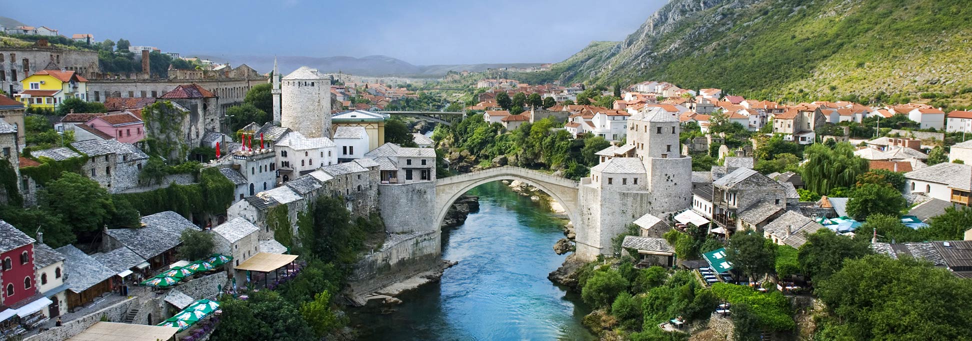
Old Town of Mostar with Stari Most (bridge) over the Neretva river.
View of the Old Town of Mostar with Stari Most (bridge) in the center, which spans the Neretva river.
Image: Ramirez

About Bosnia and Herzegovina


Flag of Bosnia and Herzegovina
The map shows Bosnia and Herzegovina, abbreviated BiH, an almost landlocked country on the western Balkan Peninsula in southeastern Europe, with a 20 km wide coastline at the Adriatic Sea (Mediterranean Sea). BiH is bordered by Croatia, Montenegro, and Serbia.

Like its border countries, Bosnia and Herzegovina was formerly one of the six constituent republics of Yugoslavia.
The state consists of two geographical regions; there is Bosnia in the north, which occupies about 80 percent of the national territory, and the smaller territory of Herzegovina in the south.

With an area of 51,197 km², the country is somewhat larger than Switzerland, or slightly smaller than the US state of West Virginia.

Bosnia and Herzegovina has a population of 3.85 million people (estimated 2019); the capital and largest city is Sarajevo. Spoken languages are Bosnian, Croatian, and Serbian. Major religions are Islam (51%) and Christianity (46%).


Map of Bosnia and Herzegovina

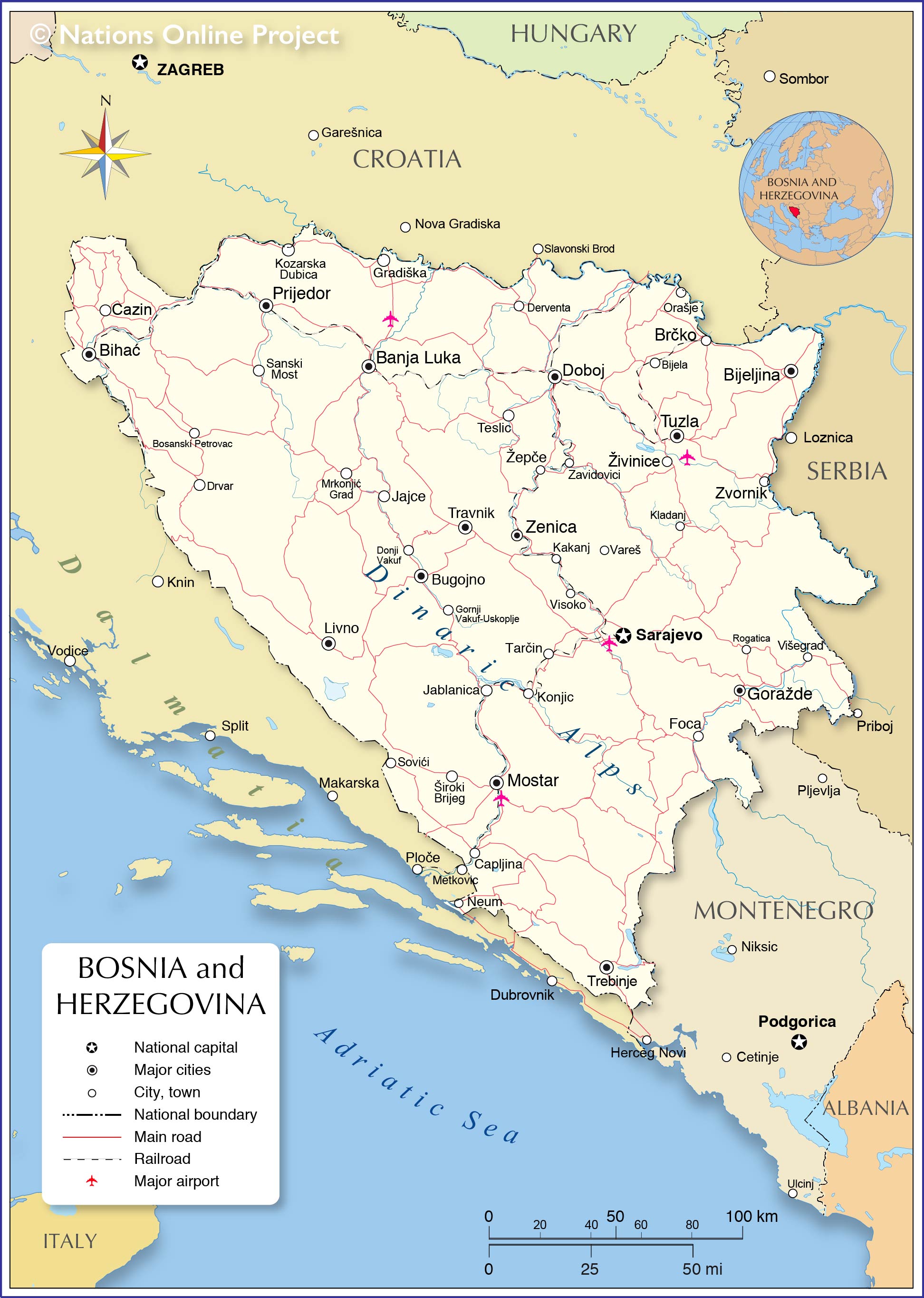
Political Map of Bosnia and Herzegovina

The map shows Bosnia and Herzegovina and surrounding countries with international borders, the national capital Sarajevo, canton capitals, major cities, main roads, railroads, and major airports.

You are free to use above map for educational purposes (fair use), please refer to the Nations Online Project.


The map shows the location of following cities and towns of Bosnia and Herzegovina:

Banja Luka, Bihać, Bijela, Bijeljina, Bosanski Petrovac, Brčko, Bugojno, Capljina, Cazin, Derventa, Doboj, Donji Vakuf, Drvar, Foca, Goražde, Gornji Vakuf-Uskoplje, Gradiška, Jablanica, Jajce, Kakanj, Kladanj, Konjic, Kozarska Dubica, Livno, Mostar, Mrkonjić Grad, Neum, Orašje, Prijedor, Rogatica, Sanski Most, Sarajevo, Sovići, Tarčin, Teslic, Travnik, Trebinje, Tuzla, Vareš, Visoko, Višegrad, Zavidovici, Zenica, Zvornik, Široki Brijeg, Žepče, and Živinice.
 

Bookmark/share this page
  Instagram button

More about Bosnia and Herzegovina:

Country:
Searchable map/satellite view of Bosnia and Herzegovina

Bosnia and Herzegovina Country Profile

Continent:
Map of the Mediterranean
Political Map of the Mediterranean Region.
Map of the Balkan Peninsula
Political Map of the Balkans.
Map of Central and Eastern Europe
Map of Europe


Weather Conditions Sarajevo:

SARAJEVO WEATHER


Advertisements:


Other Cities on the Balkan Peninsula
Athens, Belgrade, Bucharest, Constanţa, Istanbul, Ljubljana, Podgorica, Skopje, Sofia, Tirana, Zagreb

Maps of other Countries in Southern Europe
Albania Map, Croatia Map, Cyprus Map, Greece Map, Italy Map, Macedonia Map, Montenegro Map, Portugal Map, Serbia Map, Slovenia Map, Spain Map, Turkey Map, Vatican City State Map

Profiles of other Countries in Southern Europe
Albania, Bosnia and Herzegovina, Croatia, Cyprus, Greece, Italy, Macedonia, Montenegro, Portugal, Serbia, Slovenia, Spain, Turkey, Vatican City State
up