| Home |
||
 |
||
___ Map of Tutuila, American Samoa | ||
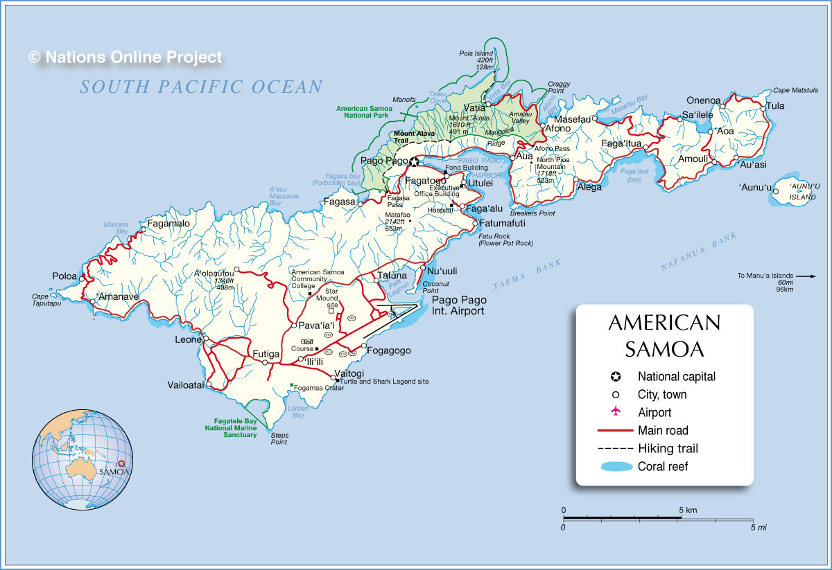
Map of the island of Tutuila, largest and most populous island of the U.S. Territory of American Samoa in the Pacific Ocean. The group of islands consists of the eastern half of the Samoan archipelago and comprises five volcanic islands and two coral atolls: the main island of Tutuila and the small Aunu’u island, plus the islands of Ofu, Olosega, and Ta’u (the Manu’a Islands) to the east. The coral atolls are: Swains, and Rose Atoll. The territory has a total land area of 199 sq km (77.6 sq mi) and its highest point is at Mt. Lata (965 m) on Ta'u Island. American Samoa has a population of 66,000. About 90 percent live on Tutuila, mostly around Pago Pago harbor. The islands extend roughly 300 km (186 mi) from west to east and are located about two-thirds of the way from Hawaii (4700 km) to New Zealand (2800 km). Capital of the island is Pago Pago. Depicted are major towns and villages, main roads, the airport, and American Samoa's National Park. |
 Bookmark/share this page |
 One World - Nations Online all countries of the world |
|
|
||
 Map of Tutuila, American Samoa |
|||||||
| Depicted on the map are the location of following towns of Tutuila and Aunu‘u island: ‘Amanave, ‘Aoa, ‘Au‘asi, ‘Aunu‘u, Afono, Alega, Amouli, Aua, Faga‘alu, Faga‘itua, Fagamalo, Fagasa, Fagatogo, Fatumafuti, Fogagogo, Futiga, ‘Ili‘ili, Leone, Masefau, Nu‘uuli, Onenoa, Pago Pago, Pava‘ia‘i, Poloa, Sa‘ilele, Tafuna, Tula, Utulei, Vailoatai, Vaitogi, and Vatia, and the location of American Samoa National Park, Fagatele Bay National Marine Sanctuary and Pago Pago International Airport (IATA code: PPG). | Pago Pago Weather Conditions
| More about American Samoa: |
Related Consumer Information: | ||||
One World - Nations Online .:. let's care for this planet Every nation is responsible for the current state of our world. |
| Site Map
| Information Sources | Disclaimer: Privacy Policy, etc. Contact: [email protected] | Copyright © 1998-2021 :: nationsonline.org |
