Advertising

Countries Index
Countries A to Z
Sovereign States
Dependent Areas
Countries by Area
Country Population
Island Countries
Countries of the Islamic World
Third World
First, Second, Third World Countries
Human Development by Country
Countries by Corruption
Countries and Press Freedom
Country Flags
Currencies

Countries of Europe

The monastic island of Mont-Saint-Michel. The Gothic-style Benedictine abbey in the Normandy was built between the 11th and 16th centuries. Mont-Saint-Michel and its Bay is since 1979 a UNESCO World Heritage Site.
Image: Mathias Neveling
European Regions
Conventionally there are four main geographical regions or subregions in Europe.
Northern Europe Western Europe Eastern Europe Southern Europe
Conventionally there are four main geographical regions or subregions in Europe.
Northern Europe Western Europe Eastern Europe Southern Europe
Some Facts about Europe
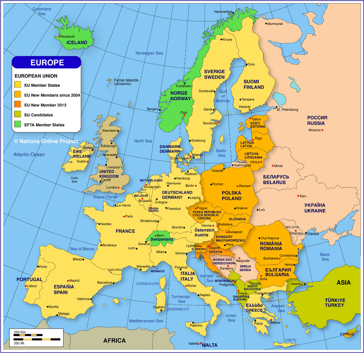
Europe is the second-smallest continent, and it could be described as a large peninsula or as a subcontinent. Europe is the western portion of the Eurasian landmass and is located entirely in the Northern Hemisphere. Several larger islands belong to Europe, such as Iceland or the British Isles with the UK and Ireland.
Area
With an area of 10.2 million km² (3,938,000 sq mi), Europe is 20% larger than the contiguous United States. The European Union has an area (without the UK) of over 4.23 million km² (1.6 million sq mi).
How many countries are there in Europe?
Europe is shared by 50 countries. By the conventional definition, there are 44 sovereign states or nations in Europe. Not included are several countries namely Turkey, which occupies only a small part of East Thrace on the European Balkan Peninsula.
Cyprus, an island in the Mediterranean Sea, is geographically part of Asia Minor (Middle East).
The Faroe Islands, an island group between the Norwegian Sea and the North Atlantic Ocean are a self-governing territory of the Kingdom of Denmark.
Greenland, which geographically belongs to North America, is as well an autonomous Danish territory.
Kosovo is a partially recognized state in the Balkans.
A small piece of Western Kazakhstan is also considered to be part of Europe.
Population
An estimated 747 million people live in Europe. The most populous country in Europe is the European part of Russia with a population of 110 million people, followed by Germany with 83 million citizens, and Metropolitan France with 67 million inhabitants (in 2020).
(Source: UN World Population Prospects)
Country
Pop.
(1000)
(1000)
Maps
Capital
Northern Europe |
||||
 Northern lights, also known as Aurora borealis, over the Lyngen fjord in Troms county of Norway. Image: Simo Räsänen |
||||
| Northern Europe refers to the portion of Europe to the north of Western Europe, the English Channel, and the Baltic Sea; it also includes the Baltic republics of Estonia, Latvia, and Lithuania. Note: EU countries are marked with an asterisk (*); EFTA member states are marked with a plus sign (+) According to the United Nations Population Division, approximately 106 million people live in Northern Europe (in 2020). See also: Map of Northern Europe. |
||||
| * Denmark | 5,813 | Denmark Map | Copenhagen | |
| * Estonia | 1,323 | Estonia Map | Tallinn | |
| Faroe Islands (DK) | 49 | Faroe Is. Map | Tórshavn | |
| * Finland | 5,551 | Finland Map | Helsinki | |
| Greenland (DK) | 56 | Greenland Map | Nuuk (Godthab) | |
| + Iceland | 341 | Iceland Map | Reykjavik | |
| * Ireland | 4,977 | Ireland Map | Dublin (City) | |
| * Latvia | 1,886 | Latvia Map | Riga | |
| * Lithuania | 2,722 | Lithuania Map | Vilnius | |
| Northern Ireland (UK) | 1,885 | Ireland Map | Belfast | |
| + Norway | 5,421 | Norway Map | Oslo | |
| Scotland (UK) | 5,424 | UK Map | Edinburgh Glasgow |
|
| * Sweden | 10,160 | Sweden Map | Stockholm | |
| United Kingdom | 68,178 | UK Map | London Birmingham, Manchester |
|
| Wales (UK) | 3,125 | UK Map | Cardiff | |
Western Europe |
||||
 The near-symmetrical pyramidal peak of the Matterhorn (height: 4,478 m). The famous mountain in Switzerland is situated in the Pennine Alps between the Swiss town of Zermatt and the Italian alpine resort of Breuil-Cervinia. Image: Gürkan Myczko |
||||
| Western Europe is the western part of Europe; it is bounded by the Atlantic Ocean in the west, the English Channel and the North Sea to the north, and by the Alps in the south. Note: EU countries are marked with an asterisk (*); EFTA member states are marked with a plus sign (+) According to the United Nations Population Division, approximately 196 million people live in Central Europe (in 2020). |
||||
| * Austria | 9,018 | Austria Map | Vienna (Wien) | |
| * Belgium | 11,613 | Belgium Map | Brussels | |
| * France | 65,375 | France Map | Paris | |
| * Germany | 83,657 | Germany Map | Berlin | |
| + Liechtenstein | 38 | Vaduz | ||
| * Luxembourg | 633 | Luxembourg Map | Luxembourg | |
| * Netherlands | 17,157 | Netherlands Map | The Hague, Amsterdam | |
| + Switzerland | 8,704 | Switzerland Map | Bern - Zürich | |
Eastern Europe |
||||
 The entry of the Baroque Wilanów Palace in Warsaw. The palace is one of Poland's most significant monuments; it was built for King John III Sobieski in the late 17th century. Image: kk nationsonline.org |
||||
| Conventionally Eastern Europe is the geographical region east of Germany and west of the Ural Mountains. The United Nations geoscheme lists ten countries including the former Eastern bloc countries of Poland, Czechia, and Slovakia (formerly Czechoslovakia), Hungary, Romania, and Bulgaria, the former Soviet republics of Belarus and Ukraine, as well as European Russia. Note: EU countries are marked with an asterisk (*) According to the United Nations Population Division, approximately 293 million people live in Eastern Europe (in 2021), including the population of the western part of the Russian Federation. |
||||
| Belarus | 9,431 | Belarus Map | Minsk | |
| * Bulgaria | 6,890 | Bulgaria Map | Sofia | |
| * Czechia | 10,713 | Czechia Map | Prague | |
| * Hungary | 9,623 | Hungary Map | Budapest | |
| Moldova | 4,030 | Moldova Map | Chisinau | |
| * Poland | 37,758 | Poland Map | Warsaw | |
| * Romania | 19,125 | Romania Map | Bucharest | |
| Russian Federation | 145,718 | European Russia Map | Moscow | |
| * Slovakia | 5,454 | Slovakia Map | Bratislava | |
| Ukraine | 43,416 | Ukraine Map Crimea Map |
Kiev | |
Southern Europe |
||||
 View of Lisbon from Parque Eduardo VII, with the Tagus river in the background. Lisbon is the capital and largest city of Portugal, the westernmost country of mainland Europe. Image: kk nationsonline.org |
||||
| Southern Europe or Mediterranean Europe refers to the mainly subtropical southern portion of the continent. The region is bounded by the Mediterranean Sea in the south. There are 13 sovereign countries in Southern Europe; seven of those states are members of the European Union. In 2021 an estimated 152 million people live in Southern Europe. Note: EU countries are marked with an asterisk (*) |
||||
| Albania | 2,868 | Albania Map | Tirana | |
| Andorra | 77 | Andorra la Vella | ||
| Bosnia and Herzegovina | 3,265 | Bosnia and Herzegovina Map | Sarajevo | |
| * Croatia (Hrvatska) | 4,079 | Croatia Map | Zagreb | |
| * Cyprus | 1,216 | Cyprus Map | Nicosia (Lefkosia) | |
| Gibraltar (UK) | 34 | Gibraltar | ||
| * Greece | 10,369 | Greece Map | Athens | |
| * Italy | 60,394 | Italy Map | Rome - Milan | |
 |
Kosovo | 1,809 | Kosovo Map | Pristina |
| North Macedonia | 2,083 | Macedonia Map | Skopje | |
| * Malta | 433 | Valletta | ||
| Monaco | 40 | Monaco | ||
| Montenegro | 629 | Montenegro Map | Podgorica | |
| * Portugal | 10,168 | Portugal Map | Lisbon | |
| San Marino | 34 | San Marino | ||
| Serbia | 8,694 | Serbia Map | Belgrade | |
| * Slovenia | 2,079 | Slovenia Map | Ljubljana | |
| * Spain | 46,726 | Spain Map | Madrid | |
| Turkey (East Thrace) | 11,704 | Turkey Map | Ankara - Istanbul | |
| Vatican City State | 1 | Holy See Map | Vatican City | |
More about Europe

View of the Mont Blanc massif. The Mont Blanc at 4,808.7 m (15,777 ft), is the highest mountain in Western Europe.
Image: Angelomalvasia
With a height of 5,642 m, Mount Elbrus is Europe's highest mountain. The dormant volcano lies in the Caucasus Mountains in southern Russia.
Mont Blanc at 4,808 m is the highest mountain in Western Europe and the highest peak of the Alps.
Largest Lakes
Lake Lagoda northeast of St Petersburg in Russia is the largest lake entirely in Europe with a surface area of 17,700 km². Lake Onega located northeast of Lake Lagoda in European Russia has a surface area of 9,700 km². Other major lakes are Lake Vänern in Sweden (largest lake in Western Europe) and Lake Saimaa in Finland.
Lake Balaton in Hungary is the largest lake in Central Europe with a surface area of 592 km².
Longest River
Europe's longest river is the Volga with a length of 3,530 km (2,190 mi); the river's catchment area is almost entirely inside Russia. The river flows into the Caspian Sea.
The second-longest river in Europe is the Danube with a length of 2,850 km (1,770 mi), the longest river in the European Union region flows through ten countries and empties into the Black Sea.
Major Geographical Regions of Europe
Major geographical regions in Europe are Scandinavia and the Scandinavian Peninsula, the Baltic Sea, the North Sea, the British Isles, the Great European Plain, the Central European Uplands, the Alps, the Mediterranean, the Italian Peninsula and the Apennine Mountains, the Iberian Peninsula, the Pyrenees, the Balkans and the Balkan Peninsula, the Black Sea and the Caucasus.
Languages of Europe
Major languages of Europe are English, French, German, Greek, Italian, Spanish, Portuguese, Nordic Languages, and East European languages. (see also: Languages of Europe)
keywords: countries of Europe, population of Europe, destination Europe, travel Europe, capitals Europe, Central Europe, North Europe, Southern Europe, East Europe
More about Europe
Capitals
 Capital Cities of Europe
Maps
General Map
of EuropeTopographic map of Europe with countries, international borders, national capitals, major cities, and geographic features.
Map
of EuropePolitical map of Member States of the European Union and EFTA, with major cities and capitals.
Map
of Central and Eastern EuropePolitical map of Central and Eastern Europe.
Map of the Baltic StatesPolitical Map of the Baltic Countries.
Map
of the Baltic Sea AreaMap of countries around the Baltic Sea.
Map of the Black SeaPolitical Map of the Black Sea.
Map of European RussiaPolitical Map of the European Russia.
Map
of the Mediterranean RegionMap of countries around the Mediterranean Sea and the Black Sea.
Map of the Balkan PeninsulaMap of the countries on the Balkan Peninsula.
Map
of Iberian PeninsulaTopographic Map of the Iberian Peninsula (Spain and Portugal).
Map
of ScandinaviaMap of countries on the Scandinavian Peninsula.
Languages
Languages of EuropeEnglish, French, German.
Flags
Flags
of EuropeAdvertisements: