
|
Home |
|
|
|
___ Political Map of Somalia |
|
The Map is showing Somalia, a country in northeastern Africa, on the peninsula known as the Horn of Africa. Depicted on the map is Somalia and the surrounding countries with international borders, the national capital Mogadishu (Somali: Muqdisho), province capitals, major cities, main roads, and major airports, and the location of the unrecognized self-declared sovereign state of Somaliland, an autonomous region in north west of Somalia. Border Countries: Djibouti, Ethiopia, and Kenya |
 Bookmark/share this page |
 One World - Nations Online all countries of the world |
|
|
||
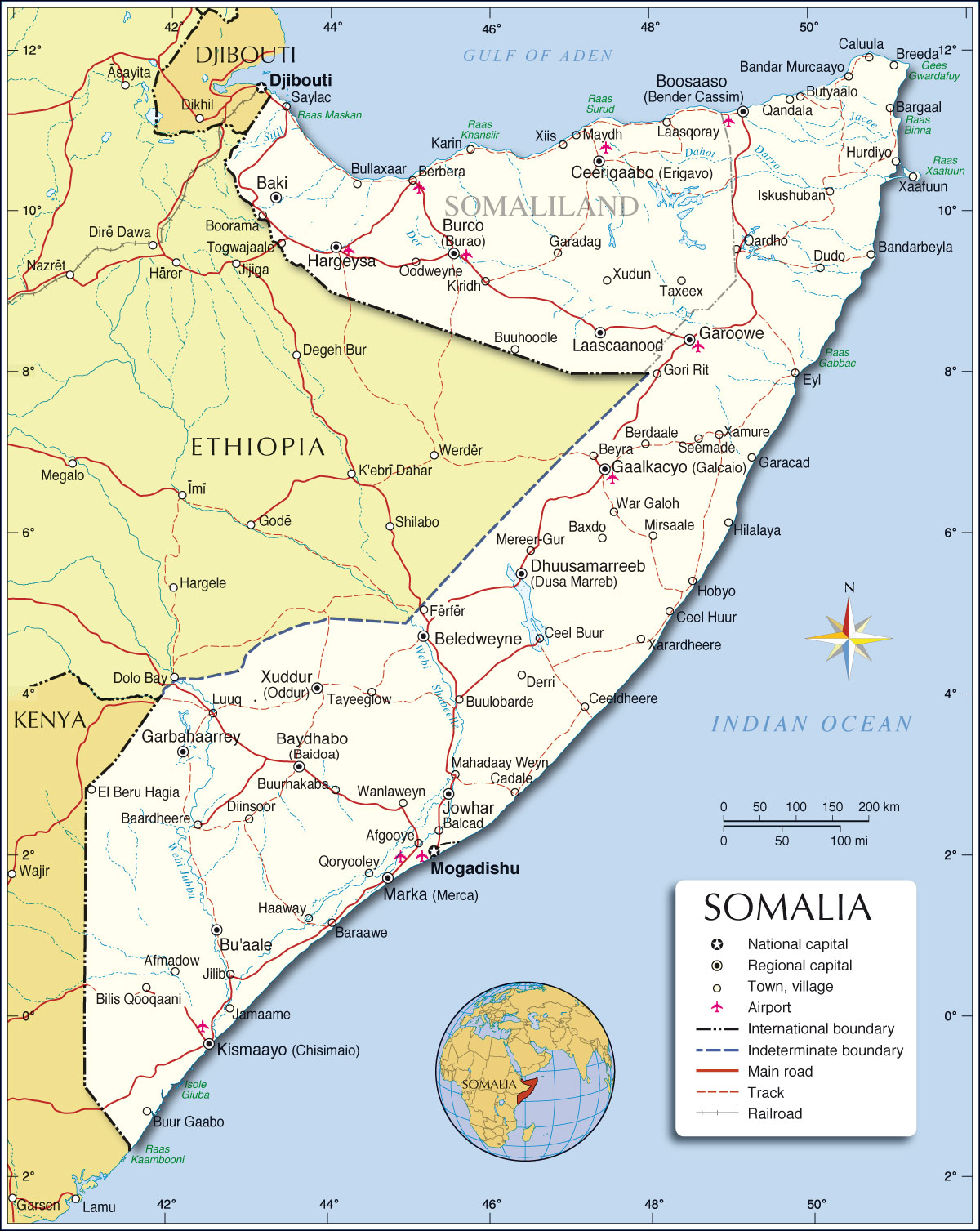 Political Map of Somalia Map based on a UN map. Source: UN Cartographic Section | |||||||
| Cities in Somalia: The map shows the location of following Somalian cities and towns: Afgooye, Afmadow, Baardheere, Baki , Balcad, Bandar Murcaayo, Bandarbeyla, Baraawe, Bargaal, Baxdo, Baydhabo (Baidoa), Beledweyne, Berbera, Berdaale, Beyra, Boosaaso (Bander Qassim), Breeda, Bu'aale, Bullaxaar, Burco (Burao), Butyaalo, Buuhoodle, Buulobarde, Buur Gaabo, Buurhakaba, Cadale, Caluula, Ceel Buur, Ceel Huur, Ceeldheere, Ceerigaabo (Erigavo) , Derri, Dhuusamareeb (Dhusa Mareb), Diinsoor, Dudo, El Beru Hagia, Eyl, Ferfer, Gaalkacyo (Galcaio), Garacad, Garadag, Garbahaarrey, Garoowe, Gori Rit, Haaway, Hargeysa, Hilalaya, Hobyo, Hurdiyo, Iskushuban, Jamaame, Jilib, Jowhar, Karin, Kiridh, Kismaayo (Chisimaio) , Laascaanood (Las Anod), Laasqoray, Luuq, Mahadaay Weyn, Marka (Merca), Maydh, Mereer-Gur, Mirsaale, Mogadishu, Oodweyne, Qandala, Qardho, Qoryooley, Saylac, Seemade, Taxeex, Tayeeglow, Wanlaweyn, War Galoh, Xaafuun, Xamure, Xarardheere, Xiis, Xuddur (Oddur), and Xudun. | More about Somalia: Cities: Country: Continent: |
Current Weather Conditions Mogadishu:
|
Related Consumer Information:
|
||||
Maps of other Countries in East Africa Burundi Map | Comoros Map | Djibouti Map | Eritrea Map | Ethiopia Map | Kenya Map Madagascar Map | Malawi Map | Mozambique Map | Réunion Map | Rwanda Map | Tanzania Map Uganda Map | Zambia Map | Zimbabwe Map Interactive Maps of other Countries in East Africa Burundi Interactive Map | Comoros Interactive Map | Djibouti Interactive Map | Eritrea Interactive Map Ethiopia Interactive Map | Kenya Interactive Map | Madagascar Interactive Map | Malawi Interactive Map Mauritius Interactive Map | Mozambique Interactive Map | Réunion Interactive Map | Rwanda Interactive Map Seychelles Interactive Map | Tanzania Interactive Map | Uganda Interactive Map Zambia Interactive Map | Zimbabwe Interactive Map Major Cities in East Africa Addis Ababa, Antananarivo, Asmara, Bujumbura, Dar es Salaam, Djibouti, Dodoma, Harare, Kampala, Kigali, Lilongwe, Lusaka, Maputo, Moroni, Mogadishu, Nairobi, Port Louis, Victoria, Zanzibar |
|||||||
One World - Nations Online .:. let's care for this planet Every nation is responsible for the current state of our world. |
| Site Map
| Information Sources | Disclaimer: Privacy Policy, etc. Contact: [email protected] | Copyright © 1998-2021 :: nationsonline.org |
