
|
Home |
|
|
|
___ Political Map of Zimbabwe |
|
| Zimbabwe is a landlocked country in South East Africa, separated from Zambia by the Zambezi River. The Limpopo River in south forms part of the border with South Africa, it is bordered in east by Mozambique, and in west by Botswana. With an area of 390,757 km² (150,872 sq mi), compared it is about half the size of Turkey or slightly larger than the US State of Montana. Highest point is Mount Nyangani (Inyangani) 2,592 m (8,504 ft) in Zimbabwe's Nyanga National Park. The mountain is the source of three rivers; the Nyamuziwa River, and the Kairezi (Gairezi) Rivers, both tributaries of the Mazowe River, a tributary of the Zambezi River, the third is the Pungwe River which flows eastward into Mozambique. Other rivers are Gwayi, Hunyani, Manisi, Mazoe, Munyati, Nata, Runde, Save, Sengwa, and Umzingwani. Zimbabwe was formerly known as Rhodesia, it declared independence from the United Kingdom in 1965, but was only recognized in April 1980. The country has a population of 13 million people, most commonly spoken languages are English, Shona and Ndebele. Map is showing Zimbabwe and the surrounding countries with international borders, the national capital Harare, province capitals, major cities, main roads, railroads and airports. |
 Bookmark/share this page |
 One World - Nations Online countries of the world |
|
|
||
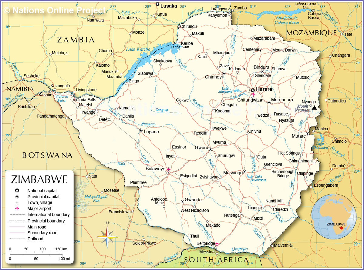 Political Map of Zimbabwe Map based on a UN map. Source: UN Cartographic Section |
|||||||
| Cities and Towns in Zimbabwe Map shows the location of following cities and towns in Zimbabwe: Largest cities are: Harare (1.5 million), Bulawayo (654,000), Chitungwiza (Chi Town; 365,000), Mutare (188,000), Gweru (158,000), Epworth (a settlement in south-eastern Harare; pop. 152,000), Kwekwe (100,000) Other cities and towns: Antelope Mine, Beitbridge, Bindura, Binga, Birchenough Bridge, Centenary, Chegutu, Chimanimani, Chinhoyi, Chipinge, Chiredzi, Chirundu, Chivhu, Dahlia (Gwayi River), Dete, Eastnor, Esigodini, Glenclova, Glendale, Gokwe, Gutu, Gwanda, Hot Springs, Hwange, Hwedza, Inyati, Kadoma, Kamativi, Kanyemba, Kariba, Karoi, Kildonan, Lupane, Makado, Makuti, Marondera, Masvingo, Matetsi, Mbizi, Mhangura, Mount Darwin, Mutoko, Muzarabani, Mvuma, Nandi Mill, Nyanga, Nyazura, Plumtree, Redcliff, Rusape, Rutenga, Shamva, Shurugwi, Siabuwa, Siyakobvu, Thuli, Triangle, Victoria Falls, West Nicholson, Zave, Zvishavane. |
More about Zimbabwe Cities: Country: Continent: |
Harare Current Weather Conditions
|
Explore More:
Related Consumer Information:
|
||||
Maps of other Countries in East Africa Burundi Map | Comoros Map | Djibouti Map | Eritrea Map | Ethiopia Map | Kenya Map Madagascar Map | Malawi Map | Mozambique Map | Réunion Map | Rwanda Map | Somalia Map | Tanzania Map Uganda Map | Zambia Map Interactive Maps of other Countries in East Africa Burundi Interactive Map | Comoros Interactive Map | Djibouti Interactive Map | Eritrea Interactive Map Ethiopia Interactive Map | Kenya Interactive Map | Madagascar Interactive Map | Malawi Interactive Map Mauritius Interactive Map | Mozambique Interactive Map | Réunion Interactive Map | Rwanda Interactive Map Seychelles Interactive Map | Somalia Interactive Map | Tanzania Interactive Map | Uganda Interactive Map Zambia Interactive Map Major Cities in East Africa Addis Ababa, Antananarivo, Asmara, Bujumbura, Dar es Salaam, Djibouti, Dodoma, Harare, Kampala, Kigali, Lilongwe, Lusaka, Maputo, Moroni, Mogadishu, Nairobi, Port Louis, Victoria, Zanzibar |
|||||||
One World - Nations Online .:. let's care for this planet Every nation is responsible for the current state of our world. |
| Site Map
| Information Sources | Disclaimer: Privacy Policy, etc. Contact: [email protected] | Copyright © 1998-2021 :: nationsonline.org |
