Advertising

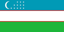
Uzbekistan Flag detail

Map of Uzbekistan

View of the Old Town of Bukhara from the Ark Fortress, Uzbekistan.
View of the Old Town of Bukhara from the Ark Fortress at sunset. Po-i-Kalyan mosque and the Kalon Minaret in the center. The Historic Centre of Bukhara external page is a UNESCO World Heritage Site.
Image: facilisis

About Uzbekistan


Uzbekistan Flag
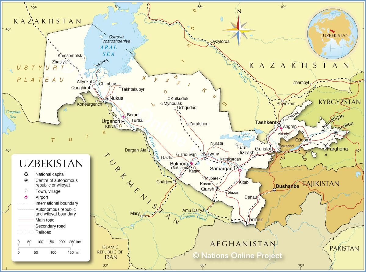
The map shows Uzbekistan, a landlocked republic in Central Asia. The country borders Kazakhstan to the north, Turkmenistan to the southwest, Afghanistan to the south, Tajikistan in the southeast, and Kyrgyzstan in the east.

Uzbekistan occupies an area of 447,400 km²; the country is about the size of Sweden or slightly larger than the U.S. state of California.

Uzbekistan has a population of 37.7 million people (in 2025), with Uzbeks making up the majority. Other major ethnic groups include Tajiks, Kazakhs, Russians, Karakalpaks, and Tatars. Spoken languages are Uzbek and Russian. The main religion is Islam; most Uzbeks follow Sunni Islam. The capital and largest city is Tashkent (Тошкент).


Map of Uzbekistan

Political Map of Uzbekistan

The map shows Uzbekistan with international borders, the national capital Tashkent, Wiloyat capitals, important cities, main roads, railroad lines, airports and important geographical features.

You are free to use the above map for educational and similar purposes; if publishing, please credit Nations Online Project as the source.


More about Uzbekistan


Ayaz-Kala in the Kyzylkum Desert, Uzbekistan
Ayaz-Kala in the Kyzylkum Desert. Ayaz-Kala is an archaeological site that consists of three mud fortresses which were built between the 4th century BCE to the 7th century CE. The fortresses once guarded the frontiers of the ancient Khorezm civilization, an ancient kingdom that thrived along the Amu Darya River.
Photo: Nicolas Rénac


Geography of Uzbekistan

Uzbekistan's landscape is dominated by dry, flat to gently rolling desert terrain, with areas of steppe, sand dunes, and sparse vegetation. The vast Kyzylkum Desert spans much of the country. Only around 10% of the country is intensively cultivated, mainly in irrigated river valleys and scattered oases.

Uzbekistan is a major producer of cotton, gold, and uranium, and holds significant reserves of natural gas.


Desert
The Kyzylkum Desert ("Red Sand" in Turkic) is a vast, extremely dry desert, mainly located in Uzbekistan. It also extends into Kazakhstan and Turkmenistan. The desert's landscape features extensive sand dunes, stony plains, and isolated oases. Its climate is characterized by extreme temperatures, with hot summers and cold winters, and sparse annual rainfall.


Mountains
The eastern and southeastern edges of Uzbekistan are fringed by mountains, including the Tian Shan and Gissar mountain ranges.

Uzbekistan's highest point
The country's highest point is Khazret Sultan, reaching 4,643 meters (15,233 ft). The mountain is located in the southern Gissar Mountains near the border with Tajikistan, northwest of Dushanbe.

The Tian Shan Mountains are a massive Central Asian mountain range, spilling into eastern Uzbekistan. Home to rugged peaks and alpine valleys.


Rivers of Uzbekistan
Main rivers are the Amu Darya, Syr Darya (Sirdaryo), and Zarafshan River.

In contrast to the dry lowlands, Uzbekistan's main rivers, the Amu Darya and Syr Darya, provide vital water for agriculture. The Amu Darya forms part of the southern border with Turkmenistan and flows northwest toward the remnants of the Aral Sea. The Syr Darya crosses the eastern Fergana Valley before curving northwest across the steppe. These rivers feed a network of canals, sustaining oases and irrigated farmland in an otherwise arid landscape.


No water in the Aral Sea, Moynaq, Uzbekistan
Looking at the Aral Sea in Moynaq, Uzbekistan. The former bottom of the sea is now a dry steppe due to desertification.
Photo: Gilad Rom


Aral Sea
The Aral Sea was once a vast inland lake in Central Asia, shared by Kazakhstan and Uzbekistan.
At its peak in the 1960s, the Aral Sea covered 68,000 km² (26,300 sq mi) — roughly the size of Ireland.
Now, the sea has largely dried up due to decades of water diversion projects initiated during the Soviet era. Rivers that once fed the sea, the Amu Darya and Syr Darya, were redirected to irrigate cotton fields in the center of Central Asia.
Once-thriving fishing villages now lie in a dusty desert. The eastern basin within Uzbekistan has shrunk into a salt-crusted plain known as the Aralkum Desert. The desert has become a habitat for wildlife, including the critically endangered Saiga antelope. The Aralkum National Nature Park was established in March 2022 in the Muynak district of the Republic of Karakalpakstan. [UZINFO]
The drying up of the Aral Sea is now considered one of the most dramatic environmental disasters in the world. It is a stark reminder of unsustainable resource use. [RFF]


Major Cities of Uzbekistan
Shahids memorial complex in Tashkent, Uzbekistan
Aerial view of the Shahids memorial complex in Tashkent, Uzbekistan.
Photo: Murodbek Yusupov


Uzbek cities such as Samarkand, Bukhara and Khiva were important stops along the ancient Silk Road, that connected China and the Orient with Europe.


Madrasas at Registan Square in Samarkand, Uzbekistan
The stunning Registan Square in Samarkand with its three madrasahs. From left to right: Ulugh Beg Madrasah, Tilya-Kori Madrasah and Sher-Dor Madrasah.
Photo: Kraftabbas


View of the city of Khiva, Uzbekistan
A view from the Islom-Khoja minaret on Khiva, an oasis city with ancient walls, minarets and unique clay buildings.
Photo: Teo Romera


The map shows the location of the following Uzbek cities and towns:


Almalyk, Altynkul, Andijon, Angren, Bekabad, Beruni, Bukhoro, Chimbay, Chirchiq, Denau, Farghona (Bukhara), Farish, Gazli, Gizhduvan, Guliston, Guzar, Jizzakh, Kagan, Kasan, Kattakurgan, Khiva, Kitab, Komsomolsk, Kulkuduk, Mubarek, Munok, Mynbulak, Namangan, Nawoiy, Nukus, Nurata, Qarshi, Qunghirot, Quqon, Samarqand, Takhtakupyr, Tashkent, Termez, Turtkul, Uchquduq, Urganch, Zarafshon, and Zhaslyk.


Advertisements:


More about Uzbekistan

Uzbekistan Country Profile
Uzbekistan in Figures
Uzbekistan key statistical data.

Map of Central Asia
Map of Southwestern Asia
Reference Map of Southwestern Asia and the Middle East.


Weather Conditions Tashkent:

TASHKENT WEATHER


Advertisements:


Other Countries in Central Asia
AFG Afghanistan, (capital: Kabul), KAZ Kazakhstan (capital: Astana), KGZ Kyrgyzstan (capital: Bishkek), TJK Tajikistan (capital: Dushanbe), TKM Turkmenistan (capital: Ashgabat)

Maps of other Countries in Central Asia:
Afghanistan Map | Kazakhstan Map | Kyrgyzstan Map | Tajikistan Map | Turkmenistan Map

Political Maps of Countries in the Middle East
Bahrain Map, Cyprus Map, Egypt Map, Iran Map, Iraq Map, Israel Map, Jordan Map, Lebanon Map, Oman Map, Qatar Map, Saudi Arabia Map, Syria Map, Turkey Map, United Arab Emirates Map, Yemen Map