
|
Home |
|
|
|
___ Political Map of Zambia |
|
Map is showing Zambia, a landlocked country in central Africa, separated from Zimbabwe by the Zambezi River. The map shows Zambia with surrounding countries, its international borders, the official national capital Lusaka, province capitals, cities, villages, roads, railroads and major airports. Border Countries: Angola, Botswana, Democratic Republic of the Congo, Malawi, Mozambique, Namibia, Tanzania, Zimbabwe |
 Bookmark/share this page |
 One World - Nations Online all countries of the world |
|
|
||
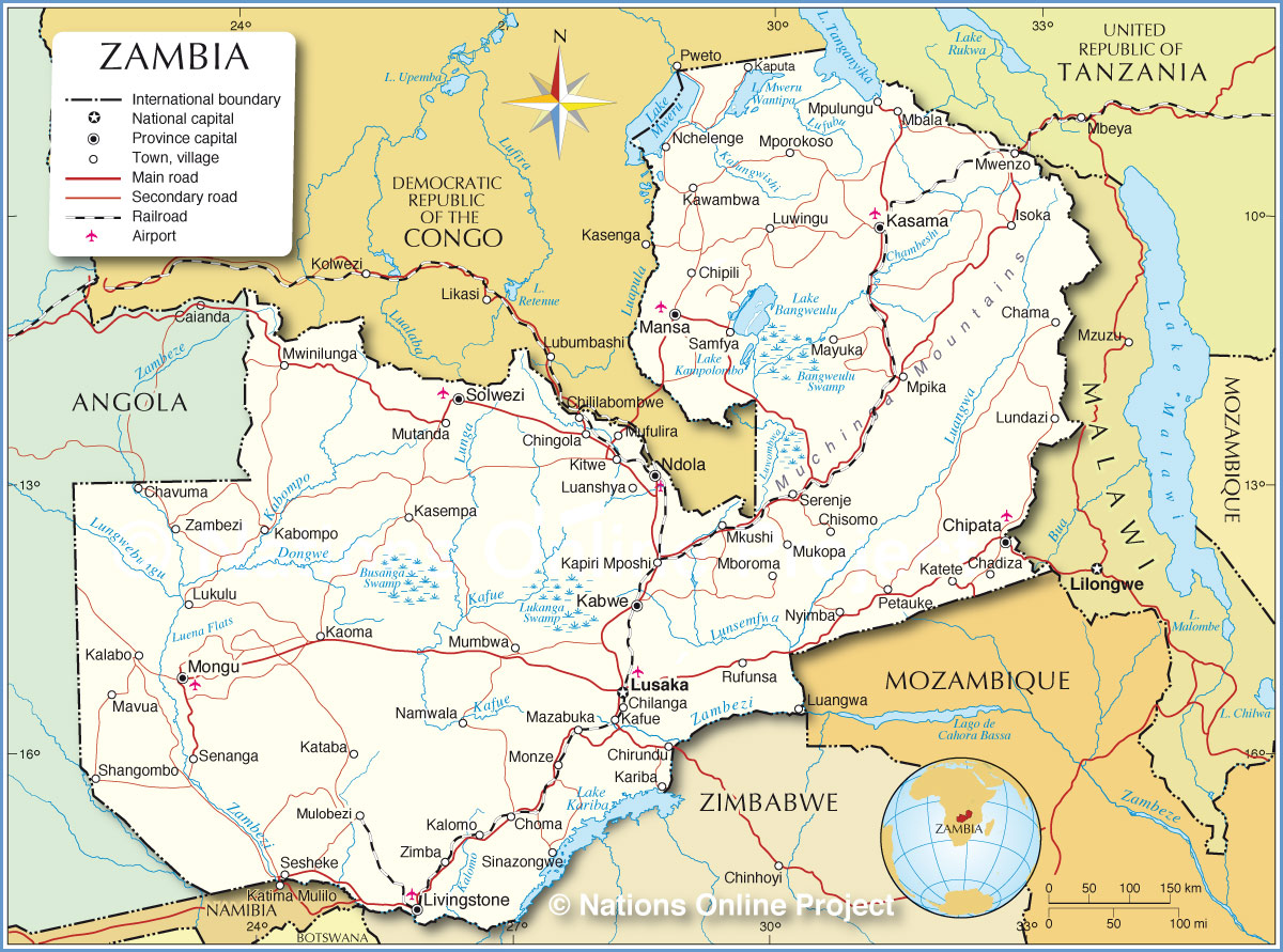 Political Map of Zambia Map based on a UN map. Source: UN Cartographic Section | |||||||
| Cities and villages in Zambia Map shows the location of following cities and villages in Zambia: Chadiza, Chama, Chavuma, Chilanga, Chililabombwe, Chingola, Chipata, Chipili, Chirundu, Chisomo, Choma, Chunga Camp, Kabompo, Kabwe (formerly Broken Hill), Kafue, Kalabo, Kalomo, Kaoma, Kapiri Mposhi, Kaputa, Kariba, Kasama, Kasempa, Kataba, Katete, Kawambwa, Kitwe (second largest city), Livingstone, Luangwa, Luanshya, Lukulu, Lundazi, Lusaka (capital and largest city), Luwingu, Mansa, Mansa, Mavua, Mayuka, Mazabuka, MbalaIsoka, Mboroma, Mkushi, Mongu, Mongu, Monze, Mpika, Mporokoso, Mpulungu, Mufulira, Mukopa, Mulobezi, Mumbwa, Mutanda, Mwenzo, Mwinilunga, Namwala, Nchelenge, Ndola, Ndola, Nyimba, Petauke, Rufunsa, Samfya, Senanga, Serenje, Sesheke, Shangombo, Sinazongwe, Solwezi, Zambezi, and Zimba. |
More about Zambia: Cities: Country: Continent: | Lusaka Weather Conditions:
|
Related Consumer Information:
|
||||
Maps of other Countries in East Africa Burundi Map | Comoros Map | Djibouti Map | Eritrea Map | Ethiopia Map | Kenya Map Madagascar Map | Malawi Map | Mozambique Map | Réunion Map | Rwanda Map | Somalia Map | Tanzania Map Uganda Map | Zimbabwe Map Interactive Maps of other Countries in East Africa Burundi Interactive Map | Comoros Interactive Map | Djibouti Interactive Map | Eritrea Interactive Map Ethiopia Interactive Map | Kenya Interactive Map | Madagascar Interactive Map | Malawi Interactive Map Mauritius Interactive Map | Mozambique Interactive Map | Réunion Interactive Map | Rwanda Interactive Map Seychelles Interactive Map | Somalia Interactive Map | Tanzania Interactive Map | Uganda Interactive Map Zimbabwe Interactive Map Major Cities in East Africa Addis Ababa, Antananarivo, Asmara, Bujumbura, Dar es Salaam, Djibouti, Dodoma, Harare, Kampala, Kigali, Lilongwe, Lusaka, Maputo, Moroni, Mogadishu, Nairobi, Port Louis, Victoria, Zanzibar |
|||||||
One World - Nations Online .:. let's care for this planet Every nation is responsible for the current state of our world. |
| Site Map
| Information Sources | Disclaimer: Privacy Policy, etc. Contact: [email protected] | Copyright © 1998-2021 :: nationsonline.org |
