About the Persian Gulf
The Persian Gulf is an arm of the
Indian Ocean, located between the mountainous coast of southwestern Iran and the rather flat coast of the
Arabian Peninsula. The gulf is about 1,000 km long and 200 to 300 km wide. It covers an area of approximately 250,000 km² (97,000 sq mi) that is somewhat larger than the size of the
UK or about the size of the
U.S. state of
Michigan. The inland sea is connected to the
Gulf of Oman in the east by the
Strait of Hormuz, a critical bottleneck between the
Iranian coast and the Omani
Musandam Peninsula for oil shipments from the Persian Gulf..
Persian Gulf Countries
Eight countries border the Persian Gulf:
Bahrain,
Iran,
Iraq,
Kuwait,
Oman (at the Musandam exclave),
Saudi Arabia,
Qatar, and the
United Arab Emirates.
More about the Persian Gulf
 Qasr Al-Watan Presidential Palace in Abu Dhabi, capital city of the United Arab Emirates.
Image: Jim Hoffman
Geography of the Persian Gulf
The Persian Gulf is fed in the northwest by the
Shatt al-Arab, a major river created by the confluence of the
Euphrates and
Tigris rivers. Some minor Iranian rivers, such as the Mond River, the Zohreh, and the Helleh River, also empty into the gulf.
The Gulf is a relatively
shallow body of water, with a
maximum depth of 90 meters (approximately 295 feet). Its average depth is around 50 meters (164 feet). The Gulf is located in a very hot and dry region and experiences significant evaporation, leading to increased salinity and density of its water.
This dense and salty water sinks and
forms a distinct water mass known as
Persian Gulf Water (PGW).
This PGW water flows out of the Gulf through the Strait of Hormuz as a
deep outflow, while surface water from the Indian Ocean flows into the Gulf.
Climate change is causing rising temperatures and increasing salinity, sea level rise, and declining oxygen levels in the waters of the Gulf. In 2020, sea temperatures reached a record-breaking 37.6 °C in the waters around Kuwait.
Short History of the Persian Gulf
 The Sheikh Zayed Grand Mosque in Abu Dhabi, the capital of the United Arab Emirates.
Image: Jim Hoffman
During the
Mesozoic Era, the area that would become the Persian Gulf was part of the vast
Tethys Ocean, a kind of shallow sea separating the ancient supercontinents of
Gondwana and
Laurasia.
Tectonic shifts gradually closed the Tethys, and the
Arabian Plate began drifting northward, colliding with the
Eurasian Plate, a slow-motion impact that lifted the Zagros Mountains and began shaping the Gulf's basin.
The Gulf as a Maritime Highway
The Persian Gulf has been a critical maritime route since antiquity, connecting the Arabian Peninsula with
Persia (now
Iran),
India, East Africa, and
Southeast Asia.
After the
rise of Islam in the 7th century, Arab traders and sailors used this corridor to spread the new faith beyond Arabia. Ports like
Basra,
Hormuz,
Muscat, and
Bahrain became centers of trade and Islamic scholarship. Muslim merchants carried not only goods like pearls, incense, and spices, but also ideas, including Islam, to distant shores.
The Persian Gulf has been a contested region for a long time.
Arabs,
Persians,
Turks, the
Portuguese, and later the
British fought to control the sea. Before
oil was discovered in the Gulf in 1908, people made their living from fishing, pearl diving, trade, and piracy.
Oil production in the Persian Gulf on an industrial scale began only in the 1930s. Today, the countries bordering the Persian Gulf produce approximately 20% of the world's oil, most of which transits the Strait of Hormuz.
Strait of Hormuz
The Strait of Hormuz is a 50 km (30 mi) wide waterway connecting the
Persian Gulf with the
Gulf of Oman, a vital maritime link between the
Gulf states and the open seas.
To regulate shipping traffic, the strait uses
designated shipping lanes (TSS), forming an approximately six nautical miles wide navigable corridor. The corridor is two nautical miles wide in each direction, with a two nautical miles wide
Separation Zone in between. These lanes run between the
Iranian coast and Qeshm Island to the north and the
Musandam Peninsula, governed by
Oman, to the south.
The Strait is of immense
strategic and economic importance. Virtually
all seaborne oil exports from the Persian Gulf must pass through it. Every day,
more than 20 million barrels of oil, about
one-fifth of global consumption, are transported via this route.
A closure of the strait, even temporarily, would have
immediate global consequences. Countries like
Saudi Arabia, the UAE, Kuwait, Iraq, Qatar, and Bahrain depend heavily on this corridor to export oil and gas. A disruption could spark panic in global markets, potentially sending oil prices soaring to
over $100 or even $150 per barrel.
Asia would be especially vulnerable. Nations such as
Japan,
South Korea,
China, and
India rely heavily on energy imports that flow through this narrow maritime passage.
Transportation in the Persian Gulf
 The airspace over the Persian Gulf is very busy, and a contentious issue—this is particularly true in mid-2025, when commercial airlines scramble to avoid flying over areas of warring countries such as Iran, Israel, Iraq, Syria, and Yemen.
Image: flightradar24.com (June 2025)
Airports
Major International Airports
There are four major international airports in the Gulf Region:
These airports are key transportation hubs for both passenger and cargo traffic in the Middle East.
Other international airports are in Basrah (Iraq), Dammam (Saudi Arabia),
Kuwait City (Kuwait),
Muscat (Oman),
Manama (Bahrain). Major airports in Southern Iran are at Bandar
Abbas, Bushehr, and the Persian Gulf Airport airport at Asaluyeh, 100 km southeast of Jam.
Major Ports in the Persian Gulf
 The Port of Jebel Ali (Dubai, UAE) is a massive, deep-water port, and one of the world's largest man-made harbors.
Image: Bryan Harris
There are a number of ports in the Persian Gulf and numerous tanker terminals along the coast and offshore.
The five major ports in the Persian Gulf are:
Bandar Abbas (Strait of Hormuz, Iran),
Jebel Ali (Dubai, UAE),
Khalifa Port (UAE), Ras Laffan (Qatar), and Hamad Port (Qatar)
The largest ports in the Persian Gulf region include
King Abdulaziz Port in Dammam, Saudi Arabia, and
Port of Jebel Ali in Dubai, UAE.
King Abdulaziz Port (Dammam, Saudi Arabia)
This port is the largest in the Arabian Gulf and a major hub for imports and exports, particularly for the oil industry. It's well-connected to the rest of Saudi Arabia via rail, facilitating efficient cargo transport.
Port of Jebel Ali (Dubai, UAE)
This is a massive, deep-water port, and one of the world's largest man-made harbors. It's a key transshipment hub and a major player in the region's trade.
Hamad Port (Qatar)
A high-capacity port, it serves as Qatar's main trade center and a key maritime transport hub in the Persian Gulf.
Shahid Rajaee Port (Iran)
Located in Hormozgan Province near B
andar Abbas in Iran. It is Iran's largest and most important port.
Iraq
The
Port of Basra, also known as Al Maqal Port, is a major Iraqi port located on the Persian Gulf in Basra.
Offshore
Al Başrah Oil Terminal (ABOT), is an Iraqi offshore, deep sea crude oil marine loading terminal, situated approximately 50 km (31 mi) southeast of the
Al-Faw Peninsula in the Persian Gulf.
Kuwait's major ports are
Shuwaikh Port in Kuwait City, and the Port of Shuaiba (container). There are several tanker terminals along Kuwait's coast.
Saudi Arabia
There are two major ports in Tarout Bay;
King Abdulaziz Seaport of
Dammam, the largest port in the Persian Gulf, and the port of Ras Tanura. Dhahran and Khobar are old Saudi port cities.
King Fahd Industrial Port is a large industrial port in Jubail; the former fishing village is now known as Jubail Industrial City, one of the world's largest industrial cities and a major civil engineering project.
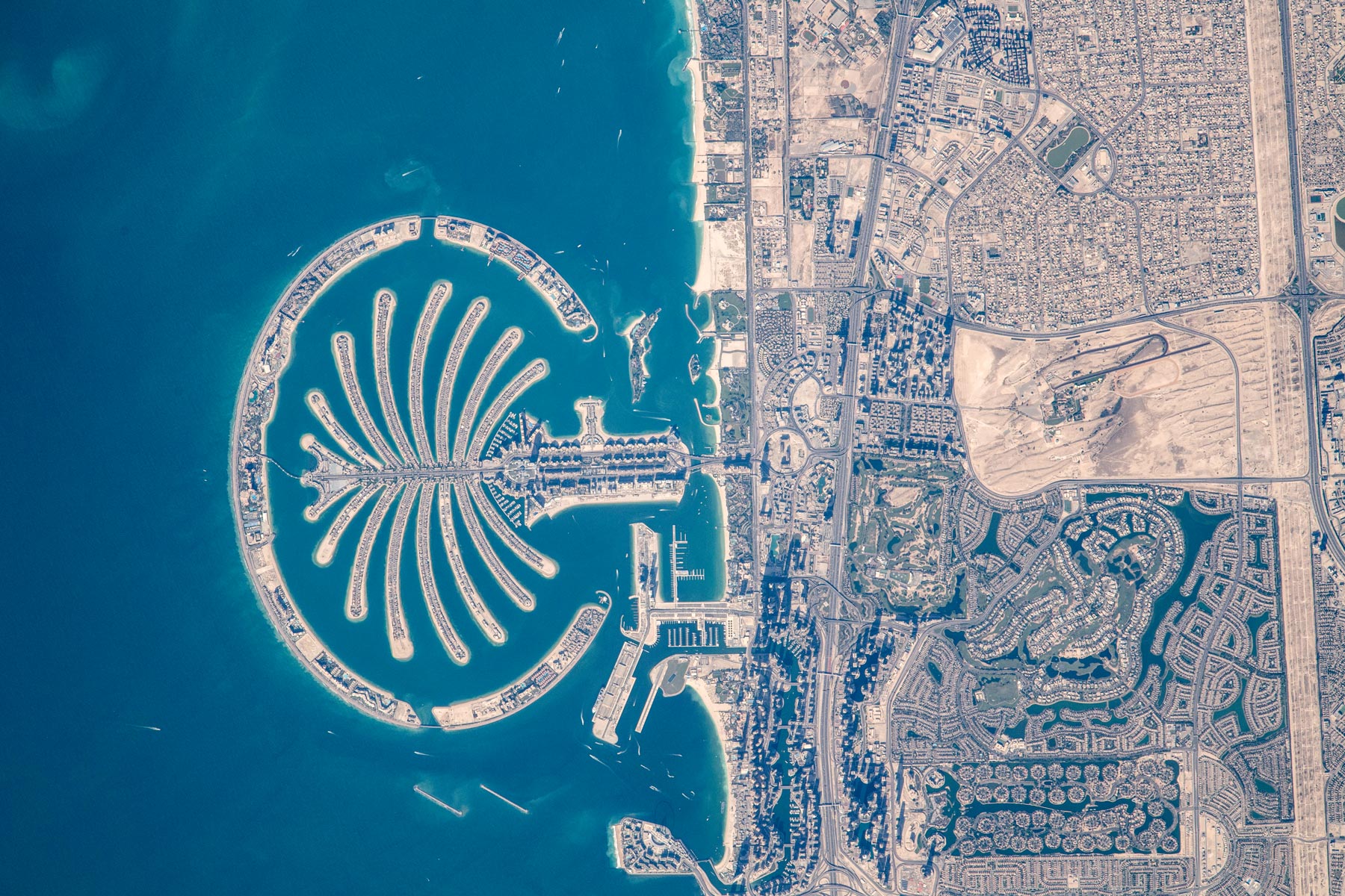 The famous Palm Islands (Palm Jumeirah) are a group of artificial islands off the coast of Dubai, United Arab Emirates. The archipelago is shaped like a palm tree with a trunk, 17 fronds, and a crescent-shaped breakwater surrounding the fronds. The three main developments are Palm Jumeirah, Palm Jebel Ali, and the Dubai Islands (formerly Deira Islands). Construction began in 2001, and the main infrastructure was largely completed by 2006. Palm Jumeirah was the first large-scale artificial island project in the Persian Gulf. The reclaimed land was created specifically for luxury residences, tourism, and leisure. It became a model for large coastal development projects in the Persian Gulf region.
Image: NASA (2021)
The famous Palm Islands (Palm Jumeirah) are a group of artificial islands off the coast of Dubai, United Arab Emirates. The archipelago is shaped like a palm tree with a trunk, 17 fronds, and a crescent-shaped breakwater surrounding the fronds. The three main developments are Palm Jumeirah, Palm Jebel Ali, and the Dubai Islands (formerly Deira Islands). Construction began in 2001, and the main infrastructure was largely completed by 2006. Palm Jumeirah was the first large-scale artificial island project in the Persian Gulf. The reclaimed land was created specifically for luxury residences, tourism, and leisure. It became a model for large coastal development projects in the Persian Gulf region.
Image: NASA (2021)
Mina Salman, south of Manama, is the primary cargo port of Bahrain.
Qatar
Hamad Port south of Doha is Qatar's main seaport.
Iran
Major port cities on the
Persian Gulf are Bandar-e Mahshahr, Bushehr, Bandar Lengeh, and Bandar Abbas.
United Arab Emirates
Jebel Ali is the largest human-made harbor and the
busiest port in the Middle East. Other major UAE ports include
Mina Rashid in Dubai;
Das Island, an offshore oil export hub in Abu Dhabi; and
Mina Zayed, now mainly serving cruise ships and local dry bulk cargo after being replaced by
Khalifa Port. In Sharjah,
Mina Khalid and
Khor Fakkan are key ports. The Khor Fakkan Container Terminal (KCT), located on Sharjah's east coast
outside the Strait of Hormuz, is one of the UAE's busiest deep-sea container terminals.


