|
|
|
 |
|
___ Map of Sinai | |
About Sinai |
|
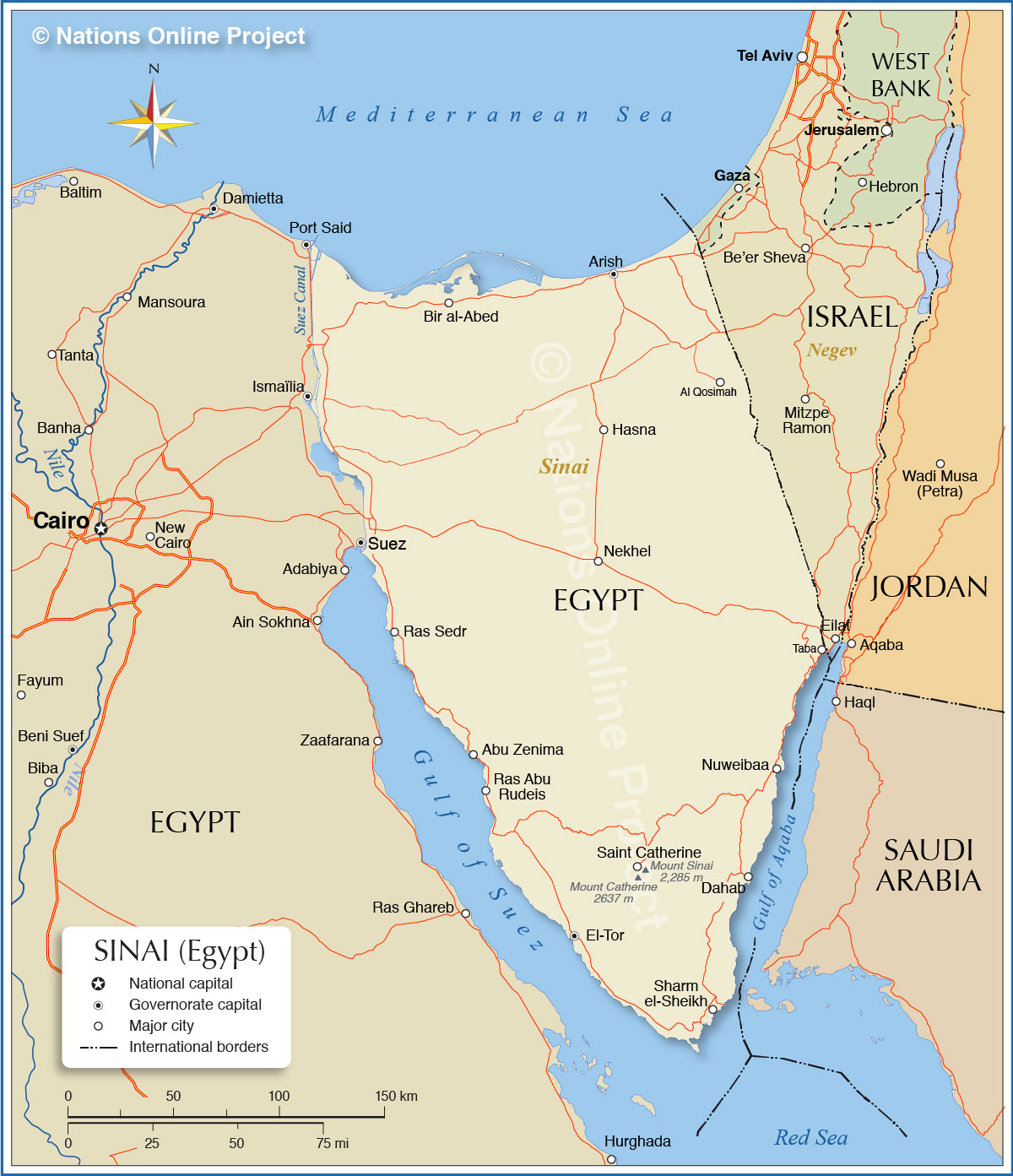
| Map is showing the Sinai Peninsula located in the Asian part of Egypt between the Mediterranean Sea to the north, and the Red Sea to the south. The Sinai Peninsula is defined by the Suez Canal and the Gulf of Suez in west and the Gulf of Aqaba in south east. The Egyptian portion of the peninsula has an area of about 60,000 km² (23,000 sq mi) this is roughly twice the size of Belgium, or somewhat smaller then than the U.S. state of West Virginia. The Sinai is sparsely populated, about 600,000 people live in the region, most of its area is desert, the southern third of the peninsula is mountainous, in the center there are several wadis, dry (ephemeral) riverbeds which contains water only during times of heavy rainfall. Sinai is divided into the two Egyptian Governorates of the North Sinai Governorate, with its administrative center at Arish (El Arīsh), and the the South Sinai Governorate with El Tor (Tur Sinai) as capital. Countries with international borders to Sinai are Palestinian territories (Gaza Strip) and Israel, Egypt shares maritime borders in the Sinai with Jordan and Saudi Arabia. Depicted on the map is Sinai peninsula and the surrounding areas with international borders, governorate capitals, major cities, main roads, and highways. |
 Bookmark/share this page 
|
 One World - Nations Online All Countries of the World |
|
|
||
 Map of Sinai Peninsula | |||||||||||
| Cities and Towns in Sinai The map shows the location of following cities and towns: Abu Zenima, Al 'Arish (capital of the North Sinai Governorate), Dahab (Sinai's most treasured diving destinations), El Tor (capital of the South Sinai Governorate), Nekhel (Nakhl), Nuweibaa (Nuweiba), Ras Abu Rudeis, Ras Sedr, Saint Catherine (nearby Saint Catherine's Monastery |
More about Egypt: Landmarks: Cities: Country: Sinai key statistical data. Continent: |
Weather Conditions Sharm el-Sheikh: Current Weather Conditions Cairo: |
Explore More:
Related Consumer Information:
|
||||||||
Other Countries in the Mediterranean: Albania | Algeria | Bosnia and Herzegovina | Croatia | Cyprus | France | Gaza Strip | Greece | Israel | Italy | Lebanon Libya | Malta | Monaco | Montenegro | Morocco | Portugal | Slovenia | Spain | Syria | Tunisia | Turkey Maps of other Countries in North Africa: Algeria Map | Libya Map | Morocco Map | Sudan Map | Tunisia Map |
|||||||||||
One World - Nations Online .:. let's care for this planet Every nation is responsible for the current state of our world. |
| Site Map
| Information Sources | Disclaimer: Privacy Policy, etc. Contact: [email protected] | Copyright © 1998-2021 :: nationsonline.org |