Advertising

Utah Flag detail
Home Earth Continents The Americas USA Country Profile US State Capitals Utah Map

US States Maps Index
World Maps Index

Map of Utah (UT)


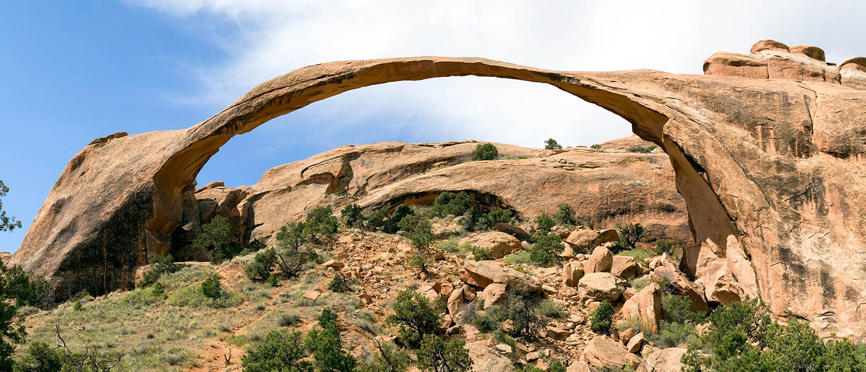
Landscape Arch in the Arches National Park in Utah
The Landscape Arch, a natural rock arch in the Arches National Park in the high desert of Eastern Utah.
Image: Cacophony

Utah Flag
Utah State Flag
 

About Utah


Location map of Utah in the United States (USA)
Where in the United States is Utah? Location map of the State of Utah in the US.
 
Utah is one of the 50 US states located in the western United States. The landlocked state borders Idaho and Wyoming in the north, Colorado in the east, Arizona in the south, Nevada in the west, and New Mexico at a single point at the Four Corners Monument.

Utah consists of 29 counties.

The region that is today Utah became part of Mexico in 1821 and was ceded to the US in 1848. Utah became the 45th state of the US in 1896.


Utah State Map
Reference Map of Utah
General Map of Utah, United States.

The detailed map shows the US state of Utah with boundaries, the location of the state capital Salt Lake City, major cities and populated places, rivers and lakes, interstate highways, principal highways, and railroads.

You are free to use this map for educational purposes (fair use); please refer to the Nations Online Project.

 
More about Utah State


Some Geography

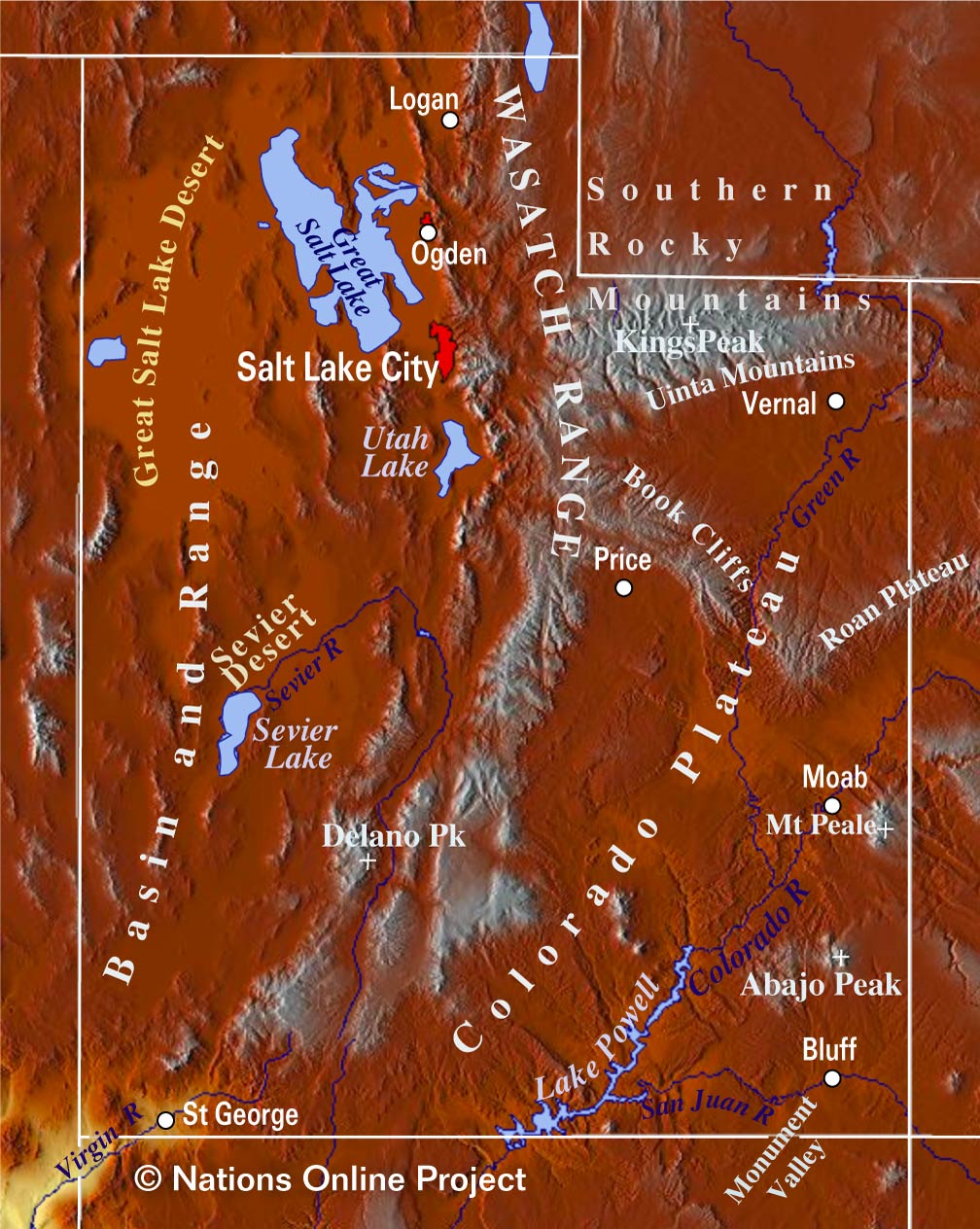
Utah Topographic Regions Map
Topographic Map of Utah showing the location major geographical features in the state: the Wasatch Mountain Range, the Great Salt Lake and Great Salt Lake Desert, the Colorado River, Utah Lake, Sevier Lake and Sevier Desert, Uinta Mountains with Kings Peak, and Monument Valley. (click on the map to enlarge)
 
Area
Utah covers an area of 219,882 km² of (84,897 sq mi) [1], compared it is somewhat smaller than the island of Great Britain (229,848 km²) or about half the size of Iraq. Compared with other US states, Utah would fit into Texas more than three times.


Lakes
Major geographical features of the Beehive State (its nickname) are the Great Salt Lake Desert, a desert formed by a large dry lake (paleolake) between the Great Salt Lake and the Nevada border, east of Salt Lake City. The evaporated lake was once part of Lake Bonneville, a prehistoric pluvial lake that covered much of the eastern part of North America's Great Basin region.

The Great Salt Lake, the largest saltwater lake in the Western Hemisphere, is also a remnant of Lake Bonneville.

Utah Lake south of Salt Lake City and west of the Wasatch Mountain Range is a shallow freshwater lake with only one river outlet, the Jordan River.

Sevier Lake in the Sevier Desert is fed by the Beaver and Sevier rivers.

Lake Powell is a reservoir on the Colorado River in southern Utah and northern Arizona. Its water is used to retain and supply water to several western United States.

 
Rivers


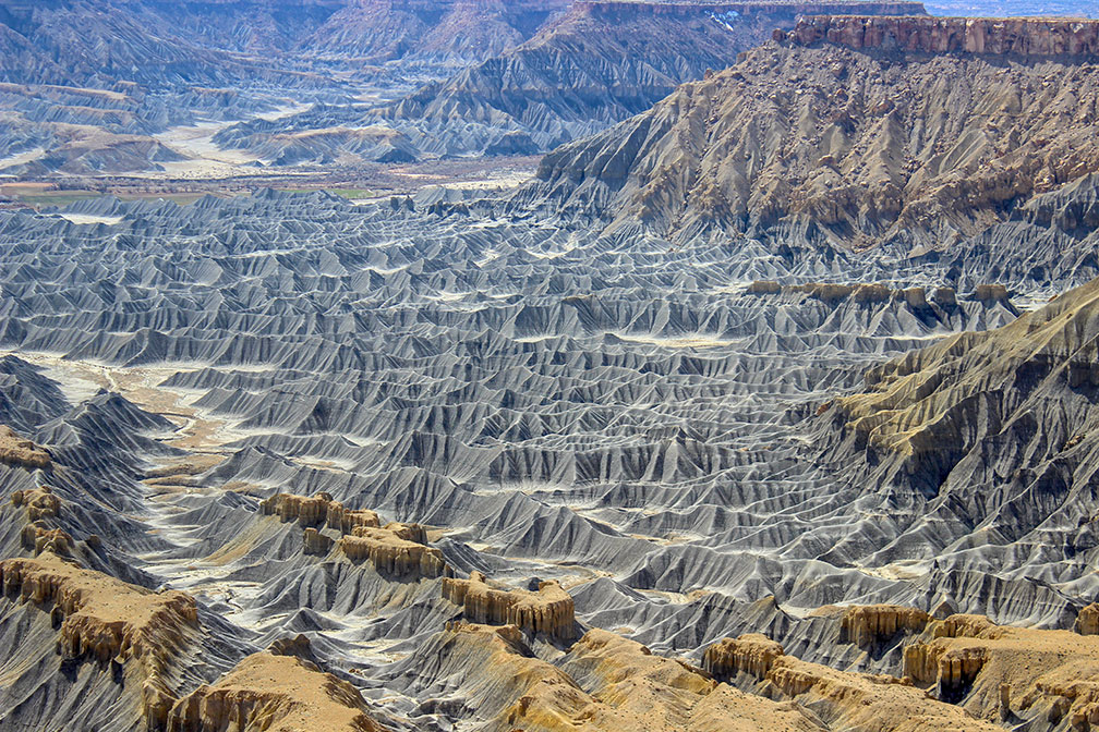
Utah Badlands at the foot of the North Caineville Plateau
Badlands at the foot of the North Caineville Plateau near Caineville. The pass carved within the Badlands by the Fremont River is known as the Blue Gate.
Image: DanHobley
 
Utah's major rivers
The Colorado is one of the principal rivers of the Southwestern United States. The Green River in the western part of the country is a chief tributary of the Colorado River. The Bear River is the largest tributary of the Great Salt Lake; it drains the mountainous area and valleys northeast of the lake.

The San Juan River in the southeastern corner of Utah is another major tributary of the Colorado River; it defines the northern border of the Navajo Reservation.
The Sevier River is the longest river 449 km (279 mi) entirely in Utah; it feeds the Sevier Lake, the rivers water is used extensively for irrigation and consequently Sevier Lake is now mostly dry.
The 388 km (241 mi) long Dolores River drains an arid region of the Colorado Plateau in Colorado before it flows into the Colorado River. Blacks Fork is a 282 km long (175 mi) tributary of the Green River. The White River is also a tributary of the Green River. The Virgin River, a 261 km (162 mi) long tributary of the Colorado, was designated Utah's first wild and scenic river. The Price River has its source in the Wasatch Range, it flows then southeastward through Price Canyon and empties into the Green River.

 
Mountains


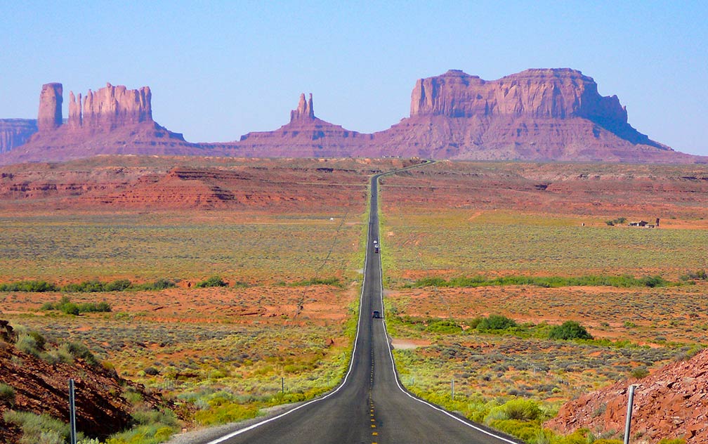
View of Monument Valley in Utah looking south on highway 163
View of Monument Valley in Utah, looking south on highway 163 from some miles north of the Arizona/Utah State line.
Image: Marc Averette

 
The Wasatch Range is a 430 km (270 mi) long mountain chain running from the Utah-Idaho border south through central Utah.

The highest peak in the Wasatch is Mount Nebo at an elevation of 3,636 m (11,928 ft).

In Utah's southeast near the city of Moab, along the Utah/Colorado border, there is the La Sal Range with its highest elevation at Mount Peale (3,877 m or 12,721 ft).

The Henry Mountains is in the southeastern portion of Utah, the highest peak is Mount Ellen at 3,512 m (11,522 ft).
The Navajo Mountain on the Utah/Arizona border is the highest point in the Navajo Nation.

Highest point
the state's highest point is Kings Peak within the Uinta Mountains in northeastern Utah, reaching 4,123 m (13,528 ft).

 
National Parks of Utah


Bryce Canyon Amphitheater in Utah
The Amphitheater at Bryce Canyon National Park in southwestern Utah.
Image: Jean-Christophe BENOIST

 
Arches National Park has some 2,000 natural sandstone arches.

Bryce Canyon features hundreds of multicolored sandstone hoodoos (fairy chimney) created by erosion (or a stoned god).

Canyonlands is a maze of canyons, mesas, and buttes shaped the waters of the Colorado River, the Green River, and their tributaries.

Capitol Reef, desert landscape with picturesque geologic landforms and rock formations in south-central Utah, facilitates scenic hiking.

The Zion National Park, with its famous Zion Canyon, is a deep and narrow gorge carved by the North Fork of the Virgin River.

Monument Valley Navajo Tribal Park is the Navajo Nation equivalent to a national park. Monument Valley is world-famous for its isolated colossal shafts and buttes of rock. The Valley lies mostly in northern Arizona, but the highway turn-off that leads into it is across the border in Utah.
 
Population


Springtime in rural Utah, at Fort Utah, Provo
Springtime in rural Utah, at Fort Utah, Provo.
Image: rcfalcon

 
Utah is in large parts only sparsely populated. Around 80% of its population of 3.2 million people (2019 est.) [2] live in the north central part of the state, at the Wasatch Front, a chain of cities and towns running roughly north to south along the Wasatch Mountain Range. Situated at its center lies Utah's capital, the largest city and metropolitan area in the state, Salt Lake City.

Other major cities are West Valley City, a suburb of Salt Lake City. Provo, the county seat of Utah County; West Jordan, another suburb of Salt Lake City; Orem, a city in Utah County; and Sandy, a city in Salt Lake County.


Race and Ethnic groups
Utah's population is composed of White 78.0%, Hispanic or Latino 14.2%, Asian 2.7%, Native American 1.5%, and African American 1.4%. [3]

By far the largest airport in the state is Salt Lake City International Airport (IATA code: SLC)


Cities and Towns in Utah

Map shows the location of following cities and towns in Utah:
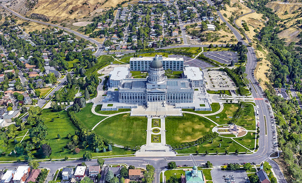
Utah State Capitol in Salt Lake City
Rendered image of Utah State Capitol in Salt Lake City. The Neoclassical Revival building is home of the seat of Utah's government.
Image: Google

Major cities are: Salt Lake City, Provo, Ogden, Park City, St. George, Orem


Other cities and towns in Utah:

American Fork, Beaver, Blanding, Bluff, Bountiful, Brigham City, Castle Dale, Cedar City, Coalville, Delta, Duchesne, Dutch John, Ephraim, Fillmore, Green River, Gunnison, Hanksville, Heber City, Hurricane, Junction, Kanab, Layton, Loa, Logan, Milford, Moab, Monticello, Morgan, Mt Pleasant, Murray, Nephi, Panguitch, Parowan, Price, Randolph, Richfield, Roosevelt, Roy, Sandy, Tooele, Torrey, Vernal, Wendover, West Valley City, and Woodruff.


View of Salt Lake City skyline with Wasatch Mountain Range in the background
Salt Lake City skyline with the Wasatch Mountain Range in the background.
Image: Garrett
 

Weather Conditions Salt Lake City:

SALT LAKE CITY WEATHER


Advertisements:


Maps of the 50 U.S. States
Alabama | Alaska | Arizona | Arkansas | California | Colorado | Connecticut | Delaware | Florida | Georgia | Hawaii | Idaho | Illinois | Indiana | Iowa | Kansas | Kentucky | Louisiana | Maine | Maryland | Massachusetts | Michigan | Minnesota | Mississippi | Missouri | Montana | Nebraska | Nevada | New Hampshire | New Jersey | New Mexico | New York | North Carolina | North DakotaOhio | Oklahoma | Oregon | Pennsylvania | Rhode Island | South Carolina | South Dakota | Tennessee | Texas | Utah | Vermont | Virginia | Washington | West Virginia | Wisconsin | Wyoming

20 Most Populous U.S. Cities (in 2018):
1. New York City 2. Los Angeles 3. Chicago 4. Houston 5. Phoenix 6. Philadelphia 7. San Antonio 8. San Diego 9. Dallas 10. San Jose 11. Austin 12. Jacksonville 13. Fort Worth 14. Columbus 15. San Francisco 16. Charlotte 17. Indianapolis 18. Seattle, 19. Denver, 20. Washington D.C.

Other Major U.S. Cities:
Albany, Anchorage, Annapolis, Atlanta, Atlantic City, Augusta, Baltimore, Baton Rouge, Bismarck, Boise, Boston, Carson City, Charleston, WV, Cheyenne, Cincinnati, Cleveland, Columbia, Concord, Des Moines, Detroit, Dover, DE, El Paso, Frankfort, Harrisburg, Hartford, Helena, Honolulu, Jackson, Jefferson City, Juneau, Kansas City, Lansing, Las Vegas, Lincoln, Little Rock, Long Beach, Madison, Memphis, Miami, Milwaukee, Minneapolis, Montgomery, Montpelier, Nashville, New Orleans, Norfolk, Oklahoma City, Olympia, Orlando, Pierre, Pittsburgh, Portland, Providence, Richmond, VA, Raleigh, Sacramento, St. Louis, St. Paul, Salem (OR), Salt Lake City, Santa Fe, Springfield, Tallahassee, Tampa, Topeka, Trenton, Tucson