
|
|
___ Political Map of Slovakia |
|
About Slovakia |
|
| Map is showing Slovakia, officially the Slovak Republic, a landlocked country in central Europe. It is bordered by Austria, the Czech Republic, Hungary, Poland, and the Ukraine. With an area of 49,035 km², the country is somewhat larger than half of Portugal or about twice the size of the U.S. state New Hampshire. The country's terrain consist of rugged mountains in the central and northern part and lowlands in the south. Its highest point is the peak of Gerlachovsky Stit with 2,655 m, the mountain is located near the state border with Poland, in the High Tatras, a mountain range that forms a natural border between Slovakia and Poland. Rivers The longest river in Slovakia is the Váh, the Morava river forms part of the Slovak border with the Czech Republic and Austria, the Danube is the largest river that flows through the country, it actually forms parts of the border with Austria and Hungary. The country has a population of 5.4 million people (in 2015), Slovakia's capital is Airport M. R. Štefánik Airport (IATA code: BTS), also known as Bratislava Airport, is Slovakia's main international airport, located 9 km (5.6 miles) northeast of Bratislava. |
 Bookmark/share this page |
 One World - Nations Online all countries of the world |
|
|
||
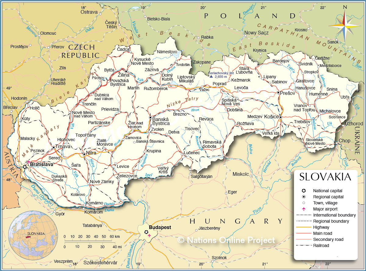 Political Map of Slovakia Map based on a UN map. Source: UN Cartographic Section |
|||||||
| Slovakia is divided into eight regions: Bratislava, Trnava, Trenčín, Nitra, Žilina, Banská Bystrica, Prešov, and Košice. The Regions are named after their Region capitals. |
|||||||
| The Map shows the location of following Slovak cities: Largest Cities (2012) after Bratislava (413,000) are: Košice (240,000), Prešov (92,000), Žilina (85,000), Nitra (85,000), Banská Bystrica (80,000) Other cities and towns: Banská Štiavnica, Bardejov, Bratislava, Brezno, Bytča, Čadca, Čertižne, Detva, Dobšiná, Dolný Kubín, Dubnica nad Váhom, Dunajská Streda, Giraltovce, Hanušovce, Hlohovec, Holíč, Humenné, Kežmarok, Kolárovo, Komárno, Krupina, Kysucké Nové Mesto, Kúty, Levice, Levoča, Lipany, Liptovský Mikuláš, Lučenec, Malacky, Martin, Medzev, Medzilaborce, Michalovce, Nové Mesto nad Váhom, Nové Zámky, Námestovo, Partizánske, Pezinok, Poprad, Považská Bystrica, Prievidza, Púchov, Revúca, Rimavská Sobota, Rožňava, Ružomberok, Sabinov, Šal'a, Sered', Slovenské Nové Mesto, Snina, Sobrance, Spišská Nová Ves, Stará L'ubovňa, Stropkov, Svidník, Tisovec, Topol'čany, Trebišov, Trenčín, Trnava, Tvrdošin, Ubl'a, Važec, Vel'ká Ida, Vel'ký Krtíš, Vranov nad Topľou, Zlaté Moravce, Zvolen, Zázrivá, Žarnovica, Želiezovce, Žiar nad Hronom. |
More about Slovakia: Cities: Country: Continent: |
Bratislava Current Weather Conditions Weather station at Vienna airport
|
Explore More:
Related Consumer Information:
|
||||
Major Cities in Central and Eastern Europe: Bucharest | Budapest | Chisinau | Kiev | Minsk | Moscow | Odessa Prague | Riga | Sofia | Sevastopol (Crimea) | Saint Petersburg | Tallinn | Warsaw | Vilnius Maps of other countries and regions in Central and Eastern Europe Belarus Map, Bulgaria Map, Czech Republic Map, Hungary Map, Moldova Map, Poland Map, Romania Map, Ukraine Map Interactive Maps of other countries and regions in Central and Eastern Europe Belarus Interactive Map, Bulgaria Interactive Map, Czech Interactive Republic Map, Hungary Interactive Map, Moldova Interactive Map, Poland Interactive Map, Romania Interactive Map, Ukraine Interactive Map |
One World - Nations Online .:. let's care for this planet Every nation is responsible for the current state of our world. |
| Site Map
| Information Sources | Disclaimer: Privacy Policy, etc. Contact: [email protected] | Copyright © 1998-2021 :: nationsonline.org |
