
|
|
___ Political Map of Guinea |
|
Guinea is a country on the west coast of Africa. With an area of 245,857 km² it is about the size of the United Kingdom or slightly smaller than the U.S. state of Oregon. The country is bordered by Côte d'Ivoire (Ivory Coast), Guinea-Bissau, Liberia, Mali, Senegal, and Sierra Leone. Guinea has a population of 10.6 million people (in 2015); capital city is Conakry; spoken languages are French (official), Fulani (Fula), Malinke, and others. Main Geographical Features of Guinea Guinea is a humid tropical country with four main geographic regions, each having its distinct human, geographic, and climatic characteristics: There are the Basse Coté lowlands of Maritime Guinea (La Guinée Maritime) also known as the Guinean forest-savanna mosaic, the alluvial coastal plains are populated mainly by Susu (Soussous) people. The Fouta Djallon of Mid-Guinea (La Moyenne-Guinée) is the highland region in the center of the country, it is populated mostly by Fulas (Fulbe or Peul people). Many of the major West African rivers begin in this area: the Niger, the Gambia (Gambie), and Senegal Rivers, as well as a number of other rivers. The Sahelian Haute-Guinea, the Eastern Savannah to the northeast is populated by Malinke people, and the forested mountainous jungle regions of Forested Guinea (Guinée forestière) in the southeast, where several ethnic groups live. The highest elevation in Guinea is Mount Nimba with 1,752 m (5,748 ft.) in the Nimba Massif, which forms a small portion of the border with Côte d'Ivoire (Ivory Coast). The mountain is located in the south eastern corner of the country, on the border with Côte d'Ivoire, not far from the province capital Nzérékoré. The Mount Nimba Strict Nature Reserve is a protected area and a UNESCO World Heritage Site in both Guinea and Côte d'Ivoire. Map is showing Guinea and the surrounding countries with international borders, provinces boundaries, the national capital Conakry, province capitals, major rivers, major cities, main roads, railroads and airports. |
 Bookmark/share this page |
 One World - Nations Online All Countries of the World |
|
|
||
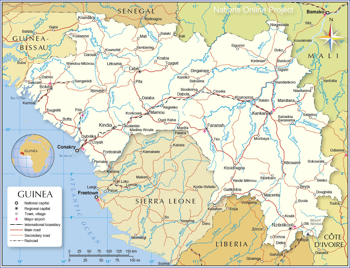 Political Map of Guinea Map based on a UN map. Source: UN Cartographic Section | |||||||
| Cities and Towns in Guinea Map shows the location of following Guinean cities and towns (region capitals in bold): Balaki, Balatoo, Bankon, Beyla, Bissikrima, Boffa, Boké, Boola, Cisséla, Conakry, Coyah, Dabiss, Dabola, Dalaba, Diéké, Dinguiraye, Doko, Dougbèla, Dubréka, Faranah, Forécariah, Foulamôri, Fria, Gaoual, Guékédou, Kali, Kalinko, Kamsar, Kankan, Kégnéko, Kérouané, Kindia, Kintinian, Kissidougou, Kolèntèn, Konkouré, Koubia, Koulé, Koundâra, Kounsitél, Kouroussa, Labé, Lélouma, Lola, Macenta, Madina Woula, Mali, Mamou, Mandiana, Maréla, Moribaya, Niagassola, Niandankoro, Niantanina, Nzérékoré, Ouré Kaba, Pamalap, Pita, Sabadou Baranama, Saladou, Sangarédi, Sansalé, Sélouma, Sènko, Sibiribaro, Siguiri, Siguirini, Sokourala, Télimélé, Tiro, Tougnifili, Tougué, Wéndou-Mbôrou, Yambéring, Yèndè Milimou, and Yomou. |
More about Guinea Cities: Country: Continent: |
Conakry Current Weather Conditions
|
Related Consumer Information:
|
||||
Political Maps of other Countries in West Africa: Benin Map | Burkina Faso Map | Cape Verde Map | Côte d'Ivoire Map | Ghana Map | Guinea-Bissau Map Liberia Map | Mali Map | Mauritania Map | Niger Map | Nigeria Map | Senegal Map | Sierra Leone Map | Togo Map |
|||||||
One World - Nations Online .:. let's care for this planet Every nation is responsible for the current state of our world. |
| Site Map
| Information Sources | Disclaimer: Privacy Policy, etc. Contact: [email protected] | Copyright © 1998-2021 :: nationsonline.org |
