Advertising

Italy Flag detail
Home Earth Continents Europe Italy Country Profile Map of Italy

Maps Index

Map of Italy, Europe


Panoramic view of Amalfi with the Amalfi Cathedral in Southern Italy
Panoramic view of Amalfi with the Amalfi Cathedral in the center. The town is situated at the Amalfi Coast, a popular tourist destination at the Gulf of Salerno in Southern Italy.
Image: Jensens

About Italy


Italy Flag
The map shows Italy, a country in southeastern Europe located for the most part on the Apennine Peninsula. Its distinct shape, resembling a kicking boot, makes it easy to recognize it on maps or even from space. Italy extends for or about 1,200 km from its borders north of the Po Valley to the tip of the 'boot' into the central Mediterranean Sea.

In the north where the peninsula is connected to mainland Europe, Italy meets the Alps, the great mountain range system in which as well Switzerland and Austria are located. In northwest Italy is bordered by France, and in the northeast by Slovenia. The Italian Peninsula is bounded by the Adriatic Sea in the east, the Sea of Sicily in the south, the Ionian Sea in the southeast, the Ligurian and the Tyrrhenian Seas in the west; all those seas are part of the Mediterranean Sea.

Italy shares maritime borders with Albania, Algeria, Croatia, Greece, Libya, Malta, Montenegro, Spain, and Tunisia.
Two of the largest Mediterranean islands belong to the country, Sardinia in the west and Sicily in the south.

Inside the Italian peninsula, there are two small political entities, the independent state of the Republic of San Marino, an enclave on the eastern side of the Apennine Mountains near the Adriatic coast, and Vatican City State, an enclave within the city of Rome and home to the Pope.

With an area of 301,318 km² (116,340 sq. mi.), Italy is 20% smaller than Japan or slightly larger than the U.S. state of Arizona.

Italy has a population of 59.3 million people (in 2021), the capital and largest city is Rome (Italian: Roma). Other major cities are Florence, Milan, Naples, and Venice. Spoken language is Italian.


Map of Italy

Political Map of Italy

Map is showing Italy and the surrounding countries with international borders, the national capital Rome, administrative region capitals, major cities, main roads, railroads, and the location of the Mont Blanc (Monte Bianco) with 4,810.45 m highest point in Europe, and Gran Paradiso mountain with 4,061 m highest point entirely in Italy. In Southern Italy the location of the volcanoes Mount Etna 3,329 m (on Sicily), Stromboli 926 m (northeast of Sicily), and Vesuvius 1,281 m (east of the city of Naples).

You are free to use the above map for educational and similar purposes; if you publish it online or in print, you need to credit Nations Online Project as the source.


More about Italy


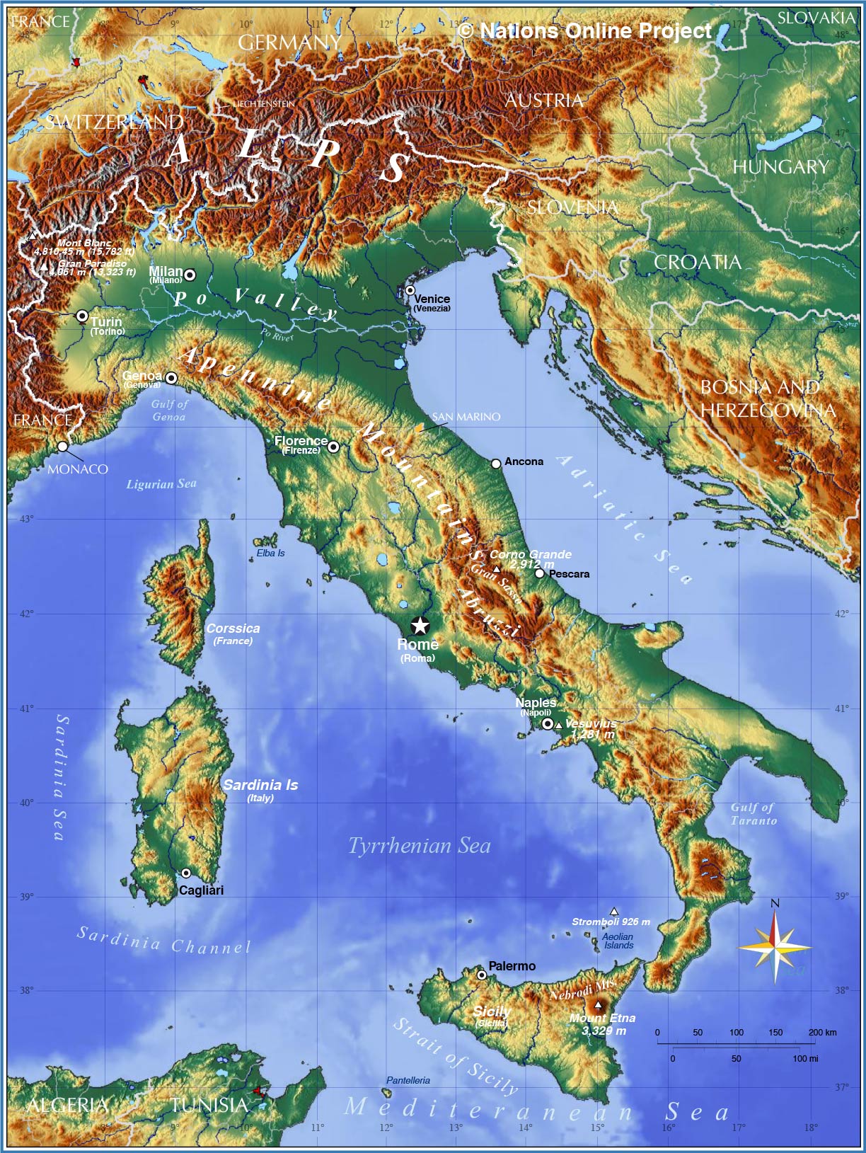
Topography of Italy
The topographic map shows mountain ranges, volcanoes, plains, major islands, and seas of Italy.
Map: nationsonline.org, topographic background: Relief Map


Italy's main geographical features

The Coasts
Italy has an impressive long coastline of 7,600 km.

The Mountains
The Alps, the world-famous mountain range in the north is partly situated in Italy. Within the Alps located are the country's highest mountains, the Mont Blanc (Monte Bianco) with 4,810.45 m (15,782 ft), unfortunately the mountain is sitting on the French-Italian border, leading to discussions if or if not this is Italy's highest mountain; however, it is the highest mountain in the Alps and even in Western Europe.
Gran Paradiso mountain at 4,061 m (13,323 ft) is just 800 m shorter and lies entirely in Italy.

The Dolomites
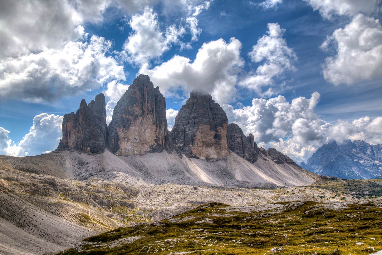
The limestone mountain range in northern Italy is made predominantly of Dolomite rocks(!) they are since 2009 a UNESCO World Heritage Site.


The Apennine Mountains or the Apennines is a mountain range consisting of smaller mountain chains which extend from the northwest to the southeast for about 1,200 km (750 mi) along the length of peninsular Italy; they join with the Maritime Alps (the southwestern part of the Alps) in the north.


The Po Valley.
The vast, fertile plain in Northern Italy along the Po River is confined by the foothills of the Alps in the west and north, and the Apennines in the south. The plain opens to the Adriatic coast in the east. The Po Basin is more or less Italy's only real big plain; today, it is also the main industrial area of the country. The Po River is the country's longest river with a length of more than 650 km; its principal direction is from west to east, and it flows into the Adriatic Sea.


Volcanism in Italy
Three Peaks of Lavaredo in the Sexten Dolomites in Italy
The Three Peaks of Lavaredo (Tre Cime) in the Sexten Dolomites of Italy.
Image: Daniele Bonaldo


All of Italy but particularly Southern Italy is a volcanically active region. There are the only active volcanoes in mainland Europe. Mount Etna, on the east coast of Sicily near the city of Catania, is Europe's most active volcano; it last erupted on 24 December 2018.
117 km to the north rises Stromboli out of the sea, a volcano that created a small island in the Tyrrhenian Sea, it is one of the eight Aeolian Islands, a volcanic archipelago off the coast of Sicily.
Mount Etna and Stromboli are active volcanoes, the third, Mount Vesuvius, which sits very close to Naples, a city with almost 1 million inhabitants; the volcano had last erupted in 1944.

The Phlegraean Fields near the town of Pozzuoli west of Naples is known to the locals as Campi Flegrei, a 13 km (8 mi) wide caldera (a collapsed volcano cone) which extends partly into the sea. There are 24 'new' craters in the area, one of it is Solfatara, a dormant volcano that still emits jets of steam with sulfurous fumes (fumaroles).

Lakes in Italy
The most prominent lakes in the country are all in Northern Italy south of the Alps. Lake Garda near Verona is Italy's largest lake. Lago Maggiore, the "Great Lake" is only second; furthermore, it lies partly in Switzerland. The lakes are all scenic attractions, but the most famous is Lake Como (Italian: Lago di Como) to the north of the city of Como in the foothills of the Alps; with an area of 146 km², it is the third largest lake in Italy.
 

Cities and towns in Italy:

The map shows the location of following Italian cities and towns:

Largest cities:
Largest city and capital is Rome (Italian: Roma; called the eternal city; pop: 3 million),
Milan (Italian: Milano; pop: 790 000), Naples (Italian: Naples; pop: 1 million), Turin (Italian: Torino; pop: 910,000), Palermo (pop: 650,000), Genoa (Italian: Genova; pop: 144 000), Bologna (pop: 380,000), Florence (Italian: Firenze; pop: 370,000), Bari (pop: 320,000), Catania (pop: 294,000), Venice (Italian: Venezia; pop: 270,000), Verona (pop: 264,000)

Other cities and towns on the Italian peninsula:
Alessandria, Amalfi, Ancona, Andria, Aosta, Arezzo, Ascoli, Assisi, Avellino, Bergamo, Bolzano/Bozen, Brescia, Brindisi, Campobasso, Carrara, Caserta, Catanzaro, Civitavecchia, Como, Cosenza, Crotone, Ferrara, Foggia, Forli, Grosseto, L'Aquila, La Spezia, Latina, Lecce, Livorno (Leghorn), Manfredonia, Matera, Modena, Montepulciano, Monza, Novara, Otranto, Padua, Parma, Perugia, Pesaro, Pescara, Piacenza, Piceno, Pisa, Potenza, Prato, Ravenna, Reggio di Calabria, Reggio Emilia, Rimini, Salerno, San Gimignano, Sanremo, Savona, Siena (Sienna), Taranto, Terni, Tivoli, Torre del Greco, Trento/Trient, Treviso, Trieste, Udine, Urbino, Verona, Vicenza, and Viterbo.

Cities and towns on Sardinia:
Cagliari, Olbia, Oristano, Porto Torres, Sassari, and Siniscola.

Cities and towns on Sicily:
Agrigento, Catania, Enna, Gela, Messina, Palermo, Syracuse (Siracusa), Taormina, and Trapani.
 

Advertisements:


Weather Conditions Rome:

ROME WEATHER


Advertisements:


Political Maps of Countries in the Mediterranean Region:
Europe: Albania Map, Bosnia and Herzegovina Map, Croatia Map, France Map, Greece Map, Italy Map, Macedonia Map, Montenegro Map, Portugal Map, Serbia Map, Slovenia Map, Spain Map, Vatican City State Map
North Africa: Algeria Map, Egypt Map, Libya Map, Morocco Map, Tunisia Map
Western Asia: Cyprus Map, Israel Map, Jordan Map, Syria Map, Turkey Map
up