| Home |
|
 |
|
___ Political Map of Croatia | |
About Croatia |
|
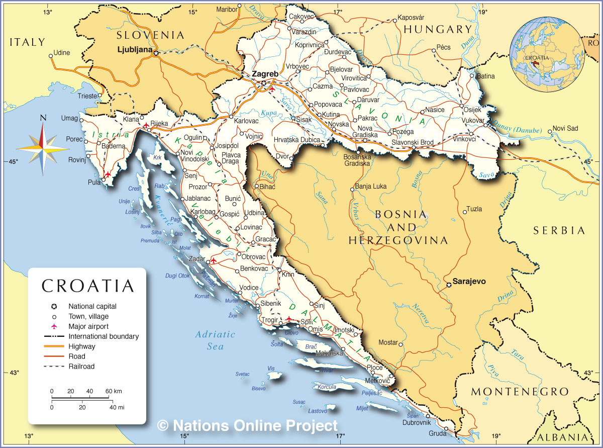
| Croatia is a country in southeastern Europe on the Balkan Peninsula, formerly one of the constituent republics of Yugoslavia. The country is bordered in south west by the Adriatic Sea, which is the northernmost arm of the Mediterranean Sea. Slovenia and Hungary are bordering Croatia in north, Bosnia and Herzegovina, and Serbia in east, it has a short border with Montenegro, and it shares maritime borders with Italy. With an area of 56,594 km² the country is slightly larger than bordering Bosnia and Herzegovina, or slightly smaller than the U.S. state of West Virginia. To the north-west of the country between the Gulf of Trieste and the Kvarner Gulf lies Istria, the largest peninsula in the Adriatic Sea. East of Istria rise the Velika Kapela and the Mala Kapela (the Large and Small Chapel) a mountain range that belongs to the Dinaric Alps which extend along the coast of the Adriatic Sea. Within the Dinaric Alps sits Mount Dinara (1,831 m; 6,007 feet) Croatia's highest point. The eastern portion of the country is known as Slavonia, one of Croatia's four historical regions. The southern part of the country is known as Dalmatia, also a historical region, the narrow coastal strip was for a long time part of the Republic of Venice (1420-1797). Major rivers in Croatia are the Sava and the Danube. The country is also well known for its about 1,000 islands in the Adriatic Sea, but only 48 or so are inhabited, their main industries are agriculture, fishing and of course, tourism. The largest islands are Krk, it is the largest island in the Adriatic Sea, second is Korčula, then Brač, Hvar, Rab, Pag, Lošinj, Ugljan, Čiovo, Murter, Vis, and Cres. Especially attractive islands for tourists are Hvar, Vis, Rab, Lastovo, Korčula, the Brijuni archipelago, Brač, Mljet, Cres, Murter, and Dugi Otok. Croatia has a population of 4,225,000 people (in 2015). Zagreb is the capital and the largest city in the country with about 800,000 residents, more than 1.2 million people live in Zagreb's urban area. The city is located at the Sava river, at the southern slopes of Mount Medvednica in the northern central part of the country. Spoken language is Croatian. The map is showing Croatia and the surrounding countries with international borders, islands, the national capital Zagreb, major cities, main roads, railroads and airports. |
 Bookmark/share this page 
|
 One World - Nations Online all countries of the world |
|
|
||
 Political Map of Croatia Map based on a UN map. Source: UN Cartographic Section | |||||||
| Cities and towns in Croatia The map shows the location of following Croatian cities and towns: Baderna, Batina, Benkovac, Bjelovar, Bosanska Gradiska, Bunic, Cakovec, Cazma, Daruvar, Dvor, Gospic, Gracac, Hrvatska Dubica, Dubrovnik (prominent tourist destination, and a UNESCO World Heritage Site), Imotski, Jablanac, Josipdol, Karlobag, Karlovac, Klana, Knin, Koprivnica, Kutina, Lovinac, Makarska, Makarska, Metkovic, Nasice, Nova Gradiska, Novska, Obrovac, Ogulin, Omis, Osijek (economic and cultural center of Slavonia; pop. 130,000), Pakrac-Durdevac, Pavlovac, Plavca Draga, Ploce, Popovaca, Porec, Pozega, Prozor, Pula, Rijeka (principal seaport and the third largest city in Croatia; pop. 130,000), Rovinj, Senj, Sibenik, Sinj, Sisak, Slavonski Brod, Split (second-largest city of Croatia; pop. 180,000), Trogir, Udbina, Umag, Varazdin, Vinkovci, Novi Vinodolski, Virovitica, Vodice, Vojnic, Vrbovec, Vukovar, Zadar, and the countries capital Zagreb. |
More about Croatia Cities: Country: Key statistical data of Croatia. Continent: Political Map of the Mediterranean Region. Political Map of the Balkans. |
Zagreb Weather Conditions: |
Related Consumer Information: |
||||
Maps of other Countries in Southern Europe Albania Map, Cyprus Map, Greece Map, Italy Map, Macedonia Map, Vatican City State Map Montenegro Map, Portugal Map, Serbia Map, Slovenia Map, Spain Map, Turkey Map |
One World - Nations Online .:. let's care for this planet Every nation is responsible for the current state of our world. |
| Site Map
| Information Sources | Disclaimer: Privacy Policy, etc. Contact: [email protected] | Copyright © 1998-2021 :: nationsonline.org |