
| Home |
|
|
|
___ Political Map of Burkina Faso |
|
Burkina Faso is a landlocked country in western Africa. Formerly the location of the Mossi Kingdoms and the Gurma people, is now bordered by six nations: Benin, Cote d'Ivoire (Ivory Coast), Ghana, Mali, Niger, and Togo, all of them former French colonial territories, with one exception, Ghana (it was a British Crown Colony). The northern part of the country is dominated by the Sahel, the arid transition zone between the Sahara Desert to the north and the African Savanna to the south, the fertile tropical grassland with a more humid climate. Burkina Faso lies on one vast plateau, a flat tableland tilted gently toward the south with an average altitude of 400 m. In the south western part of the country there are some hills where Mount Tena Kourou (747 m) stands out as Burkina's highest point. The plateau is only slightly carved out by the valleys of the three tributaries of the Volta River (Ghana), the Black Volta, the Red Volta and the White Volta River, they are the main rivers in the country. Burkina Faso's climate is generally hot and arid, with rare rainfall in the north. The south is somewhat more moist with a rainy season from May to October. With an area of 274,222 km² the country is about half the size of France or slightly larger than the U.S. state of Colorado. Until 1984 the country was known as Upper Volta. Today Burkina Faso has a population of 18.5 million (in 2015); capital city is Ouagadougou. Spoken languages are French (official), and a variety of indigenous languages. Map is showing Burkina Faso and the surrounding countries with international borders, provinces boundaries, the national capital, provinces capitals, major cities, main roads, railroads and airports. |
 Bookmark/share this page |
 One World - Nations Online All Countries of the World |
|
|
||
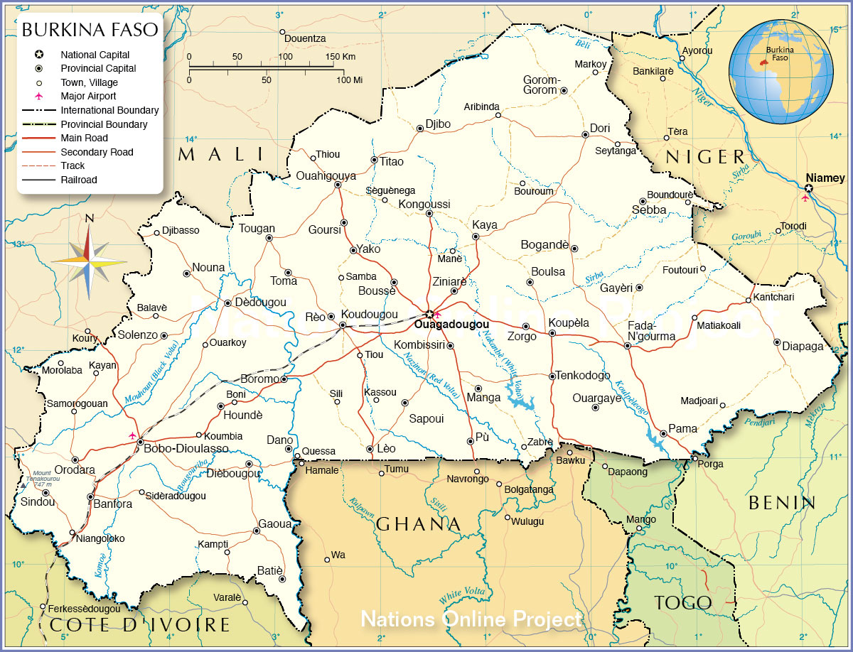 Political Map of Burkina Faso Map based on a UN map. Source: UN Cartographic Section |
Burkina Faso ProvincesFor Burkina Faso's Provinces go to |
| Cities and Towns in Burkina Faso Capital and largest city is Ouagadougou (1,630,000), Bobo-Dioulasso is the second largest city (540,000), Banfora (94,000), Koudougou (92,000), Ouahigouya (87,000), Kaya (92,000), Fada-N'gourma (52,000), Tenkodogo (49,000) Other Cities and Towns: Aribinda, Balavè, Batiè, Bogandè, Boni, Boromo, Boulsa, Boundourè, Bouroum, Boussè, Dano, Dèdougou, Diapaga, Dièbougou, Djibasso, Djibo, Dori, Foutouri, Gaoua, Gayèri, Gorom-Gorom, Goursi, Houndè, Kampti, Kantchari, Kassou, Kayan, Kombissiri, Kongoussi, Koumbia, Koupèla, Lèo, Madjoari, Manè, Manga, Markoy, Matiakoali, Morolaba, Niangoloko, Nouna, Orodaro, Ouargaye, Ouarkoy, Pama, Pù (Po), Quessa, Rèo, Samba, Samorogouan, Sapoui, Sebba, Seytanga, Sèguènega, Sidèradougou, Sili, Sindou, Solenzo, Thiou, Tiou, Titao, Toma, Tougan, Yako, Zabrè, Ziniarè, and Zorgo |
More about Burkina Faso: Cities Country: Continent: |
Weather Conditions Ouagadougou :
|
Explore More:
Related Consumer Information:
|
||||
Political Maps of other Countries in West Africa: Benin Map | Cape Verde Map | Côte d'Ivoire Map | Ghana Map | Guinea Map | Guinea-Bissau Map Liberia Map | Mali Map | Mauritania Map | Niger Map | Nigeria Map | Senegal Map | Sierra Leone Map | Togo Map |
|||||||
One World - Nations Online .:. let's care for this planet Every nation is responsible for the current state of our world. |
| Site Map
| Information Sources | Disclaimer: Privacy Policy, etc. Contact: [email protected] | Copyright © 1998-2021 :: nationsonline.org |
