
|
|
___ Political Map of the Republic of Côte d'Ivoire (Ivory Coast) |
|
| About Côte d'Ivoire Côte d'Ivoire (also known as Ivory Coast), a country in West Africa, on the Gulf of Guinea (North Atlantic Ocean) between Ghana and Liberia. The country is bordered in north by Mali and Burkina Faso. With an area of 322,463 km² the Ivory Coast is slightly smaller than Poland, or slightly larger than than the U.S. state of New Mexico. The country's highest point is Mount Nimba (Mount Richard-Molard) with 1,752 m located at the border to Guinea, Liberia. Three major river run through Côte d'Ivoire, the Sassandra River (in west), the Bandama River (in center), and the Komoé River (in east), they all flow into the Gulf of Guinea. Largest lake is Lake Kossou in the center of the country, an artificial lake created in 1973 by damming the Bandama River with the Kossou Dam. Built into the dam is a 176 MW hydroelectric power plant. Ivory Coast has a population of 22.7 million inhabitants (in 2015). Capital city is Yamoussoukro. Largest city and the defacto capital is Abidjan. Spoken languages are French (official); and languages of five principal language groups, the main ones are Diula (Dioula), Baule (Baoulé), Dan, Anyin and Senari. The map shows Côte d'Ivoire with surrounding countries, its international borders, the official national capital Yamoussoukro as well as the defacto capital of Abidjan, provinces capitals, cities, villages, rivers and lakes, roads, railroads and major airports. |
 Bookmark/share this page |
 One World - Nations Online All Countries of the World |
|
|
||
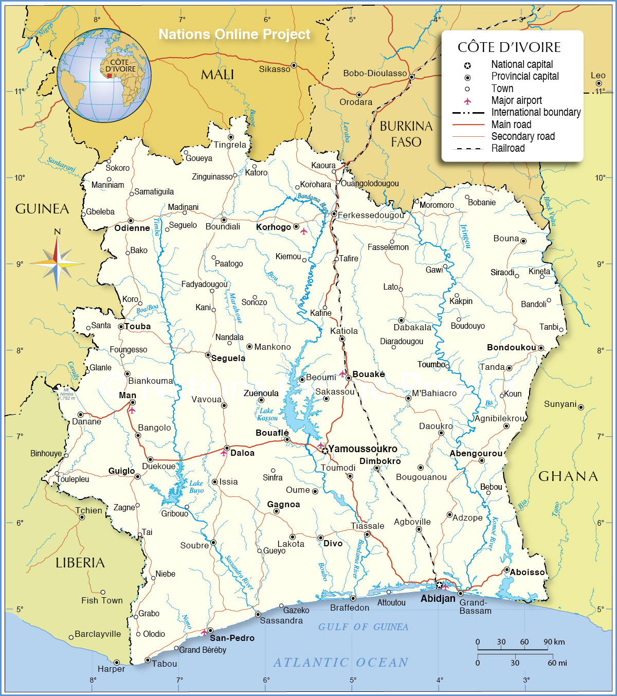 Political Map of Côte d'Ivoire Map based on a UN map. Source: UN Cartographic Section | |||||||
| Map shows the location of following cities and villages in Côte d'Ivoire (Ivory Coast): Abengourou, Abidjan (largest city), Aboisso, Adzope, Agboville, Agnibilekrou, Attoutou, Bako, Bandoli, Bangolo, Bebou, Beoumi, Biankouma, Binhouye, Bobanie, Bondoukau, Bouafle, Bouake, Boudouyo, Bougouanou, Bouna, Boundiali, Braffedon, Dabakala, DaloaIssia, Danane, Daoukro, Diaradougou, Dimbokro, Divo, Duekoue, Fadyadougou, Fasselemon, Ferkessedougou, Foungesso, Gagnoa, Gaoua, Gawi, Gazeko, Gbeleba, Glanle, Goueya, Grabo, Grand Béréby, Grand-Bassam, Gribouo, Gueyo, Guiglo, Kafine, Kakpin, Kani, Kaoura, Katiola, Katoro, Kiemou, Kineta, Korhogo, Koro, Korohara, Koun, Lakota, Lato, M'Bahiacro, Madinani, Man, Maniniam, Mankono, Moromoro, Nandala, Niebe, Odienne, Ouangolodougou, Oume, Paatogo, Sakassou, Samatiguila, San-Pédro (second largest port), Santa, Sassandra, Seguela, Seguelo, Sinfra, Siraodi, Sokoro, Sonozo, Soubre, Tabou, Tafire, Tai, Tanbi, Tanda, Tiassale, Tingrela, Touba, Toulepleu, Toumbo, Toumodi, Vavoua, Yamoussoukro (capital city), Zagne, Zinguinasso, and Zuenoula. |
More about Côte d'Ivoire: Cities: Country: Continent: |
Abidjan Weather Conditions:
|
Related Consumer Information:
|
||||
Political Maps of other Countries in West Africa: Benin Map | Burkina Faso Map | Cape Verde Map | Ghana Map | Guinea Map | Guinea-Bissau Map Liberia Map | Mali Map | Mauritania Map | Niger Map | Nigeria Map | Senegal Map | Sierra Leone Map | Togo Map |
|||||||
One World - Nations Online .:. let's care for this planet Every nation is responsible for the current state of our world. |
| Site Map
| Information Sources | Disclaimer: Privacy Policy, etc. Contact: [email protected] | Copyright © 1998-2021 :: nationsonline.org |
