
| Home |
|
|
|
___ Administrative Map of Republic of the Congo |
|
About the of Republic of the Congo |
|
| The Republic of the Congo is also known as Congo-Brazzaville or just Congo. The country is located in Central Africa (Equatorial Africa) with a short (170 km) coastline at the South Atlantic Ocean. It is bordered by Angola (enclave of Cabinda), Cameroon, Central African Republic, Democratic
Republic of the Congo (Kinshasa), and Gabon. With an area of 342,000 km² Congo is slightly smaller than Germany, or as well slightly smaller than the U.S. state of Montana. Congo has a population of 4.5 million people, capital city is Brazzaville, located at the Congo River, just opposite of Kinshasa, the capital of the Democratic Republic of the Congo. Map is showing the Republic of the Congo and the surrounding countries with international borders, provinces boundaries, the national capital Brazzaville, provinces capitals, major cities, main roads, railroads and airports. |
 Bookmark/share this page |
 One World - Nations Online all countries of africa |
|
|
||
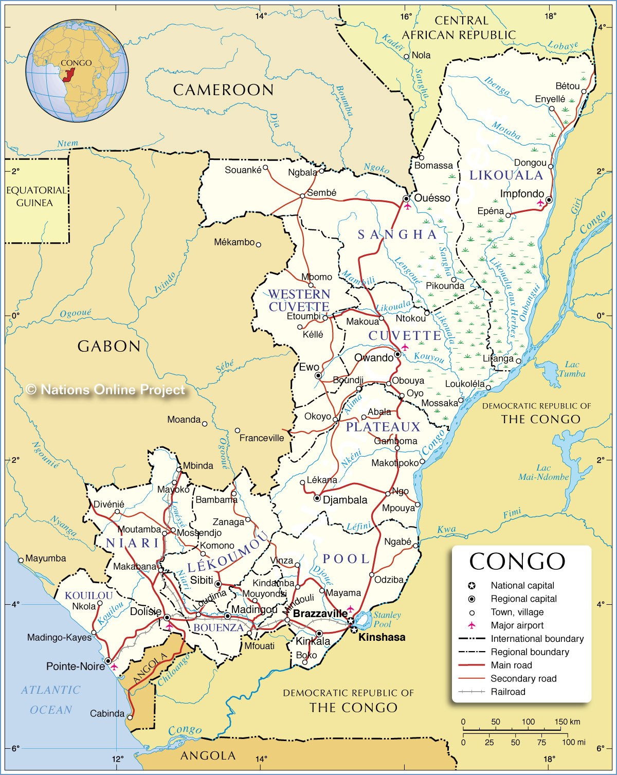 Administrative Map of Republic of the Congo Map based on a UN map. Source: UN Cartographic Section | |||||||
|
Administrative Divisions The Republic of the Congo is divided into 12 administrative divisions, 10 provinces and two cities: Brazzaville and Pointe Noire. The 12 departments (départements) are: (regional capital in Parenthesis) Bouenza (Madingou), Cuvette (Owando), Cuvette-Ouest (Western-Cuvette; Ewo), Kouilou (Pointe-Noire), Lékoumou (Sibiti), Brazzaville (Brazzaville), Likouala (Impfondo), Niari (Dolisie), Plateaux (Djambala), Pool (Kinkala), Sangha (Ouésso), and Pointe Noire (Pointe Noire). |
More about the Republic of the Congo: Cities: Country: Continent: |
Brazzaville Current Weather
|
Related Consumer Information:
|
||||
| Maps of other Countries in Central Africa Angola Map | Cameroon Map | Central African Republic Map | Chad Map Democratic Republic of the Congo Map | Equatorial Guinea Map | Gabon Map |
|||||||
One World - Nations Online .:. let's care for this planet Every nation is responsible for the current state of our world. |
| Site Map
| Information Sources | Disclaimer: Privacy Policy, etc. Contact: [email protected] | Copyright © 1998-2021 :: nationsonline.org |
