
| Home |
|
|
|
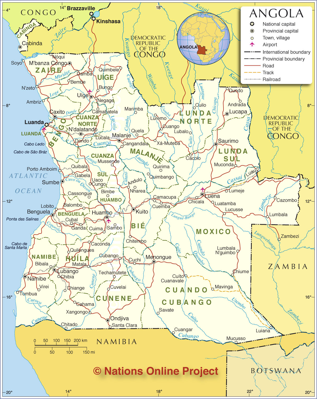
___ Political Map of Angola |
|
About Angola |
|
| Angola is a republic on the western coast of southern Africa. The country has an area of 1,246,700 km², compared it is slightly larger than South Africa or slightly less than twice the size of the U.S. state of Texas. Angola has a population of 24.4 million people (census 2014). Spoken languages are Portuguese (official), and several Bantu languages. Largest city and the national capital is Luanda. Angola is bordered by the Atlantic Ocean in west, Namibia in the south, the Democratic Republic of the Congo (former Zaire) in the north, and Zambia in the east. The exclave province of Cabinda is separated from Angola by a tongue of the Democratic Republic of the Congo and has also borders with the Republic of the Congo. Principal airport of Angola is Quatro de Fevereiro Airport (IATA code: LAD), Luanda, major regional airports are located at Huambo, Luena, and Uìge. Map is showing Angola and surrounding countries with international borders, and Angola's provinces (províncias) with boundaries. |
 Bookmark/share this page |
 One World - Nations Online countries of the world |
|
|
||
 Administrative Map of Angola |
|||||||
| Administrative Divisions, the Provinces of Angola Angola is divided into eighteen provinces (províncias). The provinces are (provincial capitals in parentheses): Bengo (Caxito) | Benguela (Benguela) | Bié (Kuito) | Cabinda (Cabinda) | Cuando Cubango (Menongue) | Cuanza Norte (N'dalantando) Cuanza Sul (Sumbe) | Cunene (Ondjiva) | Huambo (Huambo City, second largest city in Angola) | Huila (Lubango) | Luanda (Luanda) | Lunda Norte (Lucapa) Lunda Sul (Saurimo) | Malanje (Malanje) | Moxico (Luena) | Namibe (Namibe) | Uíge (Uige) | Zaire (M'Banza Congo) |
More about Angola: Cities: Country: Continent: |
Luanda Current Weather
|
Related Consumer Information:
|
||||
| Maps of other Countries in Central Africa Cameroon Map | Central African Republic Map | Chad Map | Republic of the Congo Map Democratic Republic of the Congo Map | Equatorial Guinea Map | Gabon Map | |||||||
One World - Nations Online .:. let's care for this planet Every nation is responsible for the current state of our world. |
| Site Map
| Information Sources | Disclaimer: Privacy Policy, etc. Contact: [email protected] | Copyright © 1998-2021 :: nationsonline.org |
