Advertising

Arizona Flag detail
Home Earth Continents The Americas USA Country Profile US State Capitals Arizona Map

US States Maps Index
World Maps Index

Map of Arizona (AZ)


Mystery Valley, part of the Monument Valley, Arizona
The Mystery Valley is a part of the Monument Valley in Arizona.
Image: Bernard Gagnon


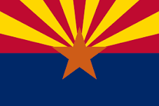
Flag of Arizona
Arizona State Flag


About Arizona


Location map of Arizona state USA
Where in the United States is Arizona? Location map of Arizona in the US.

 
Arizona is a landlocked state situated in the southwestern United States, bordering Mexico in the south.

The Grand Canyon State (its nickname) borders Utah to the north, New Mexico to the east, the Mexican states of Sonora and Baja California to the south, California in the west, and Nevada in northwest. At the Four Corners’ Point, Arizona meets Colorado in the extreme the northeast.


Climate
Most of Arizona has a desert or semi-desert climate, while the north has a steppe climate. As a result, there are relatively mild winters and hot summers, depending on the altitude.
There can be significant temperature differences between day and night, because of the proximity to the Rocky Mountains.


Arizona State Map

Reference Map of Arizona
General Map of Arizona, United States.

The detailed map shows the US state of Arizona with boundaries, the location of the state capital Phoenix, major cities and populated places, rivers and lakes, interstate highways, principal highways, and railroads.

You are free to use this map for educational purposes (fair use); please refer to the Nations Online Project.

 
Short History


Arizona Topographic Regions Map
Topographic Map of Arizona. (Click the map to enlarge)
 
Spain colonized the area in 1598. Arizona was part of New Spain until 1821, and then part of the short-lived Mexican Empire which became the United Mexican States. In 1846 United States forces invaded and occupied the region, at that time known as Nuevo México (New Mexico).

The Treaty of Guadalupe Hidalgo ended the war between the United States and Mexico in 1848. In 1850 New Mexico became a US territory. In the Gadsden Purchase of 1854, the US pays Mexico $10 million for 76,845 km² (29,670 sq mi) of Mexican territory that becomes part of Arizona and New Mexico.

The area was organized as a US territory in 1863 from lands ceded by the Treaty of Guadalupe Hidalgo in 1848. Copper was discovered in 1854, and copper mining was Arizona’s chief industry until the 1950s.
Arizona was the 48th state and the last of the contiguous states to be admitted to the Union on 14th February 1912.

 
More about Arizona State


Some Geography

Area
Sonoran Desert in Saguaro National Park, Arizona
Sonoran Desert in Saguaro National Park.
Image: Joe Parks
 
Arizona occupies an area of 295,234 km² (113,990 sq mi) [1], compared Arizona would fit into Texas about 2.4 times, the state is slightly smaller than Italy (301,318 km²) or the Philippines (300,000 km²).


Highlights of Arizona's Landscape

Arizona is known for its desert landscape in the southern half.
The Colorado Plateau in the northern part of the state is primarily made up of high desert, with scattered areas of forests. Part of the plateau is the Painted Desert and the Petrified Forest National Park.

On the Arizona-Utah state line, there is Monument Valley with its well-known sandstone buttes, the tallest reaching 300 m (1,000 ft) above the valley floor. The valley has been featured in many movies, especially Western films.

Highest Elevation
Humphreys Peak is the highest natural point in the state with 3,852 m (12,637 ft) located within the Kachina Peaks Wilderness about 18 km (11 miles) north of Flagstaff.

 
Major Rivers


Horseshoe Bend of the Colorado River, Arizona
Horseshoe Bend of the Colorado River near the town of Page in Arizona.
Image: Paul Hermans

 
Major Rivers in Arizona.
The Colorado River is one of the principal rivers of the Southwestern United States. It forms a section of the state line between Arizona with Nevada and most of the border to California. The Little Colorado River is a tributary of the Colorado; it provides the main drainage of the Painted Desert region.

The Gila River iflows through New Mexico and Arizona and is a 1,044 km (649 mi) long major tributary of the Colorado River. The Salt River is the largest tributary of the Gila River and the Verde River is a major tributary of the Salt River.
The Santa Cruz River in southern Arizona and northern Sonora in Mexico is another major tributary of the Gila River. The Puerco River in northeastern Arizona drains an arid terrain, including parts of the Painted Desert. The Virgin River is a tributary of the Colorado and forms the north arm of Lake Mead, the largest reservoir in the United States, in terms of water capacity. The source of the San Francisco River is near Alpine, Arizona; it flows later into the upper Gila River. The San Pedro River in southern Arizona is also a tributary of the Gila River.

 
World Heritage Site

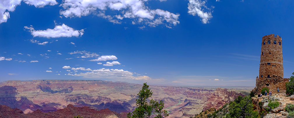
Desert View Watchtower and Grand Canyon on South Rim, Arizona
Desert View Watchtower. The 21 m high stone building is located on the South Rim of the Grand Canyon. The four-story tower was designed by American architect Mary Colter and completed in 1932. The interior contains murals by Fred Kabotie. The upper floors serve as an observation deck from which visitors can view eastern portions of the Grand Canyon.
Image: Vladsinger


Arizona has one UNESCO World Heritage Site. In the northwestern part of the state is one of America's best known natural landmarks, the Grand Canyon. It is quite certainly the most spectacular gorge on this planet.

The Colorado River and its tributaries formed the steep-sided canyons of stratified bands of red rock over a period of 2 billion years. The canyon is 446 km (277 mi) long, and up to 29 km (18 mi) wide, and in places over 1,500 m (nearly 1 mile) deep.

Grand Canyon National Park UNESCO official website is one of 23 UNESCO World Heritage Sites in the US.

Grand Canyon, view from the South Rim
The Grand Canyon, view from the South Rim.
Image: Roger Bolsius
 
Population


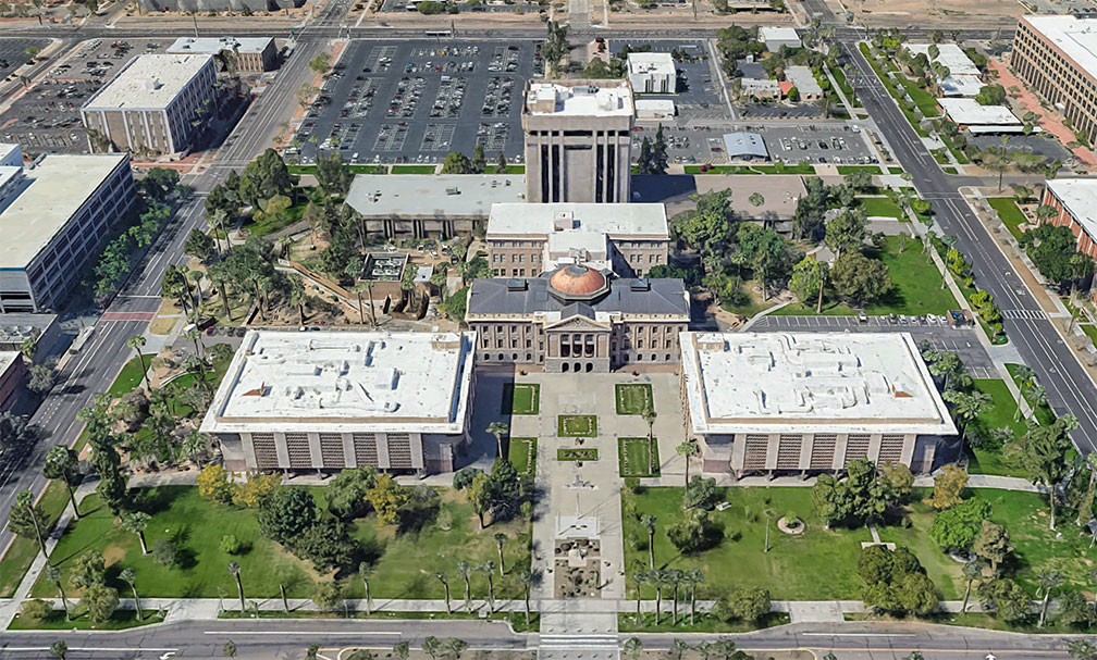
Arizona's State Capitol in Phoenix, Arizona
Rendered image of Arizona's State Capitol in Phoenix. The original Classical Revival building was the seat of Arizona's Territorial government until Arizona became a state in 1912. The 1901 portion of the Capitol is now maintained as the Arizona Capitol Museum.
Image: Google

The Grand Canyon State (Arizona's nickname) has a population of 7.3 million people (in 2019). [2] The capital and largest city is Phoenix; ; the second-largest city is Tucson, with more than half a million people; the largest urban area is Phoenix Metropolitan Area (pop. 4.85 million).

Other major cities (pop. more than 200,000) are Mesa, Chandler, Glendale, Scottsdale, and Gilbert.


Race and Ethnic groups
The population of Arizona is composed of White alone 54.4%, Hispanic or Latino 31.6%, Native American 5.3%, African American 5.1%, and Asian 3.7%. [3]


The busiest airport is Phoenix Sky Harbor International Airport (IATA code: PHX).


Cities in Arizona

The map shows the location of following cities and towns in Arizona:

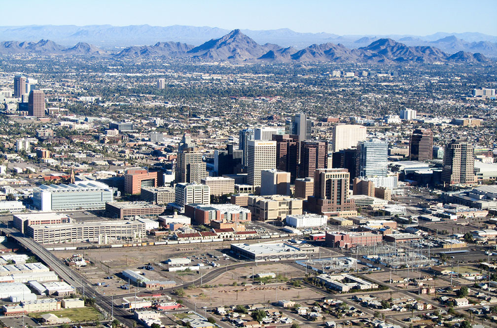
Aerial view of Downtown Phoenix with Piestewa Peak, Arizona
Aerial view of Arizona's capital Phoenix with Piestewa Peak in the background, the second-highest peak in the Phoenix Mountains.
Image: Melikamp
 

Major cities are Phoenix, Tucson, Scottsdale, Tempe, Mesa, and Glendale.

Other cities and towns in Arizona:

Ajo, Alpine, Ash Fork, Benson, Bisbee, Buckeye, Bullhead City, Camp Verde, Casa Grande, Chandler, Chinle, Clifton, Colorado City, Cottonwood, Douglas, Eagar, Eloy, Flagstaff, Florence, Gila Bend, Globe, Grand Canyon, Green Valley, Holbrook, Kayenta, Kingman, Lake Havasu City, Lukeville, Marana, Miami, Nogales, Oro Valley, Page, Parker, Payson, Peach Springs, Polacca, Prescott, Quartzite, Safford, San Luis, Sedona, Sells, Show Low, Sierra Vista, Snowflake, St Johns, Superior, Tombstone, Tuba City, Wickenburg, Willcox, Williams, Window Rock (Capital of Navajo Nation), Winslow, and Yuma.


Weather Conditions Phoenix:

PHOENIX WEATHER


Advertisements:


Maps of the 50 U.S. States
Alabama | Alaska | Arizona | Arkansas | California | Colorado | Connecticut | Delaware | Florida | Georgia | Hawaii | Idaho | Illinois | Indiana | Iowa | Kansas | Kentucky | Louisiana | Maine | Maryland | Massachusetts | Michigan | Minnesota | Mississippi | Missouri | Montana | Nebraska | Nevada | New Hampshire | New Jersey | New Mexico | New York | North Carolina | North DakotaOhio | Oklahoma | Oregon | Pennsylvania | Rhode Island | South Carolina | South Dakota | Tennessee | Texas | Utah | Vermont | Virginia | Washington | West Virginia | Wisconsin | Wyoming

20 Most Populous U.S. Cities (in 2018):
1. New York City 2. Los Angeles 3. Chicago 4. Houston 5. Phoenix 6. Philadelphia 7. San Antonio 8. San Diego 9. Dallas 10. San Jose 11. Austin 12. Jacksonville 13. Fort Worth 14. Columbus 15. San Francisco 16. Charlotte 17. Indianapolis 18. Seattle, 19. Denver, 20. Washington D.C.

Other Major U.S. Cities:
Albany, Anchorage, Annapolis, Atlanta, Atlantic City, Augusta, Baltimore, Baton Rouge, Bismarck, Boise, Boston, Carson City, Charleston, WV, Cheyenne, Cincinnati, Cleveland, Columbia, Concord, Des Moines, Detroit, Dover, DE, El Paso, Frankfort, Harrisburg, Hartford, Helena, Honolulu, Jackson, Jefferson City, Juneau, Kansas City, Lansing, Las Vegas, Lincoln, Little Rock, Long Beach, Madison, Memphis, Miami, Milwaukee, Minneapolis, Montgomery, Montpelier, Nashville, New Orleans, Norfolk, Oklahoma City, Olympia, Orlando, Pierre, Pittsburgh, Portland, Providence, Richmond, VA, Raleigh, Sacramento, St. Louis, St. Paul, Salem (OR), Salt Lake City, Santa Fe, Springfield, Tallahassee, Tampa, Topeka, Trenton, Tucson