Advertising

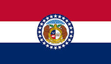
Missouri Flag detail
Home Earth Continents The Americas USA Country Profile US State Capitals Missouri Map

US States Maps Index
World Maps Index

Map of Missouri (MO)


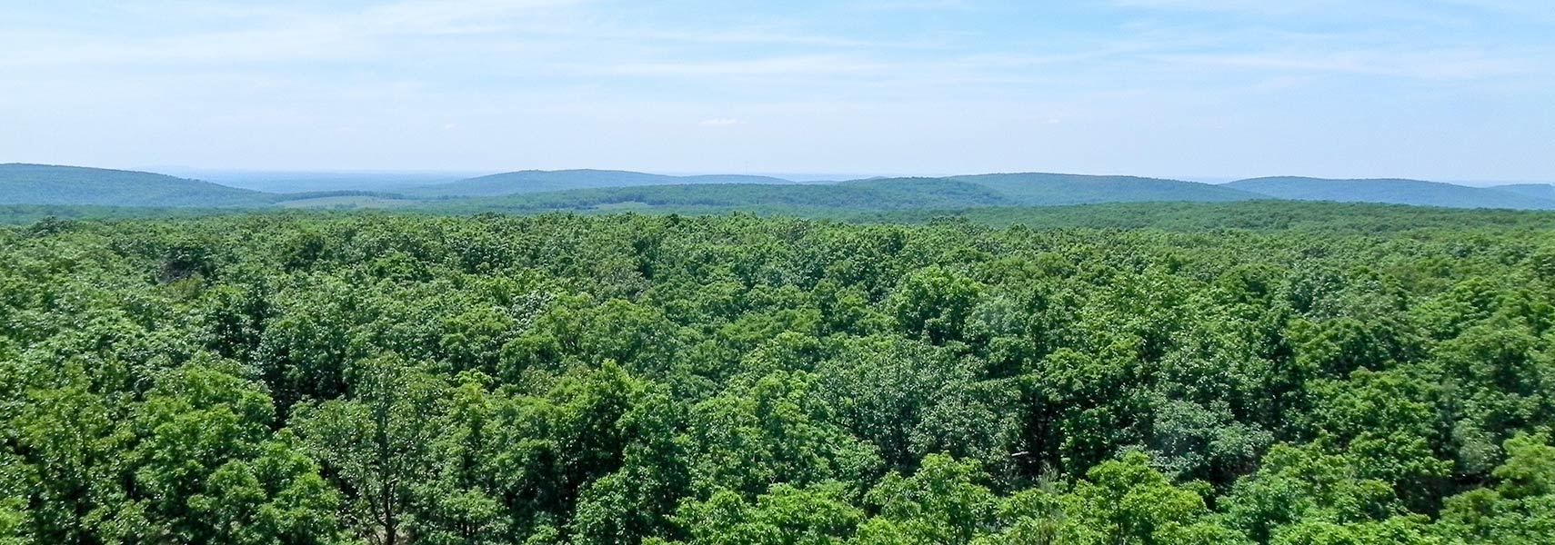
The Ozark Highlands. View from the lookout tower on Taum Sauk Mountain in Missouri.
The Ozark Highlands, view from the lookout tower on Taum Sauk Mountain, the highest point in Missouri. The Ozarks cover an area of nearly 122.000 km² (47,000 sq mi), making it by far the largest mountain area between the Appalachians in the east and the Rocky Mountains in the west. Together with the Ouachita Mountains, the region is known as the US Interior Highlands.
Image: Fredlyfish4

Missouri Flag
Missouri State Flag


About Missouri


Location map of Missouri state in the USA Where in the United States is Missouri? Location map of the State of Missouri in the US.
 
Missouri is a landlocked state in the Midwestern United States on the fringes of the Bible Belt.

Missouri was named after the Missouri River, which in turn takes its name from the Missouria, a Native American tribe.

The Show Me State (Missouri's unofficial nickname) borders a total of eight different US states.

Bordering states are Iowa in the north, Illinois in the east across the Mississippi River, Kentucky in southeast, Tennessee and Arkansas in the south, Oklahoma and Kansas in the west, and Nebraska across the Missouri River in the northwest.


Missouri State Map
Reference Map of Missouri
General Map of Missouri, United States.

The detailed map shows the US state of Missouri with boundaries, the location of the state capital Jefferson City, major cities and populated places, rivers and lakes, interstate highways, principal highways, and railroads.

You are free to use this map for educational purposes (fair use); please refer to the Nations Online Project.
   
More about Missouri State


History
Missouri Topographic Regions MapTopographic Regions Map of Missouri. (Click on the map to enlarge)
 
The United States acquired the area of Missouri from France as part of the Louisiana Purchase in 1803. Missouri Territory was organized on 4 June 1812 from Louisiana Territory. It included all of the present-day states of Arkansas, Iowa, Kansas, Missouri, Nebraska, and Oklahoma and parts of Colorado, Minnesota, Montana, Nebraska, New Mexico, North Dakota, South Dakota, Texas, and Wyoming.

On 2 March 1821, a small part of the Missouri Territory was admitted to the Union as Missouri as the 24th state.


Some Geography
Missouri covers an area of 180,540 km²; [1] compared, this is about half the size of Germany or a quarter of the size of Texas. Missouri's landscape offers an upland plain prairie region in the north, the Missouri portion of the mountainous Ozark Plateau in the southwest, and the Mississippi Alluvial Plain in the Missouri Bootheel region in the southeastern corner of the state.


Major Geographical Regions of Missouri


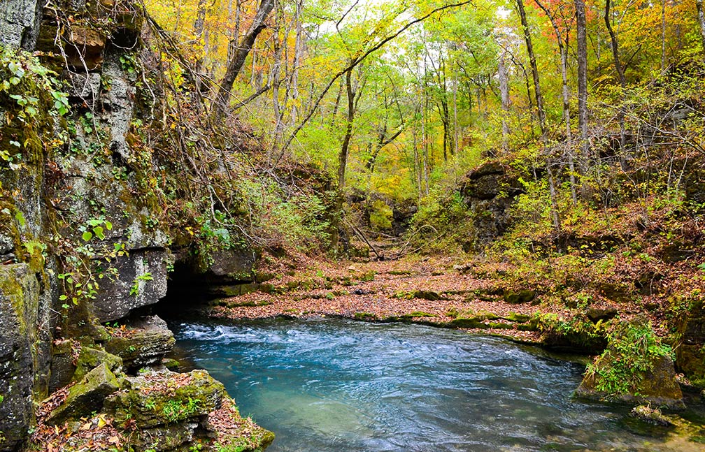
Greer Spring in the southeast portion of the Ozark Plateau
Greer Spring within the boundaries of the Mark Twain National Forest in the southeast portion of the Ozark Plateau, in Oregon County, Missouri. It is the second-largest spring in the Ozarks, with an average discharge of 10 m³ (360 cubic feet) of water per second.
Image: Kbh3rd

 
Missouri can be divided into four geographical regions.

1. The Central Dissected Till Plains are situated north of the Missouri River, high prairie landscapes with savanna and woodland valleys. The wide floodplains of the Missouri River and the Mississippi River developed complexes of sandbars, marshes, and wet prairies. Today, much of the Central Dissected Till Plains have been converted to productive pastures and cropland. [2]


2. The Osage Plains in west-central Missouri are mostly flat plains with a few hills. Once a tallgrass prairie, but in the 19th and beginning of the 20th century, settlers transformed what was then known as the "Great American Desert" or "The Inland Sea" into farmland. The tallgrass prairie survives in tiny areas unsuited for agriculture, like in Missouri's Prairie State Park in Barton County.


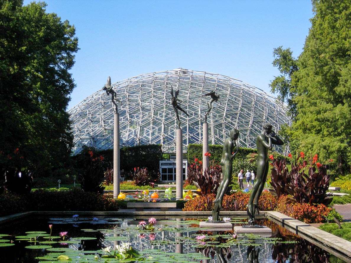
Climatron Geodesic Dome at the Missouri Botanical Garden in St. Louis, Missouri
The Climatron Geodesic Dome at the Missouri Botanical Garden (Shaw's Garden) in St. Louis. The garden is one of the oldest horticultural institutions in the United States.
Image: Chris Yunker

 
3. The Ozark Plateau, Missouri’s largest geographical region, is a heavily forested highland plateau dissected by rivers, valleys, and streams. There are two mountain ranges within the Ozarks: the Boston Mountains of Arkansas and the St. Francois Mountains of Missouri, created by volcanic and intrusive activity 1.48 billion years ago. Portions of the Ozark Plateau, the Springfield Plateau, consisting of eroded limestone. Missouri is known as "The Cave State" with over 6000 recorded caves; the majority of these caves are found in the Ozarks. [3]
4. The Mississippi Alluvial Plain a lowland in the "Boot Heel" of the state along the Mississippi River. The broad Mississippi lowlands along the state's eastern borders are also known as the Mississippi embayment.


Highest point
Missouri's highest point is at Taum Sauk Mountain, a flat ridge at 540 m (1,772 ft), situated in a large parks-and-wilderness area, the Taum Sauk Mountain State Park in the St. Francois Mountains in the Ozarks. Another wilderness area is the Bell Mountain Wilderness of southern Missouri's Mark Twain National Forest.


Population

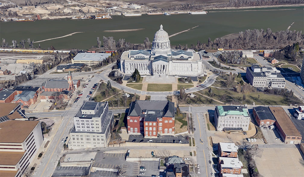
Missouri State Capitol in Jefferson City
Poorly rendered image of Missouri State Capitol in Jefferson City. The Capitol building houses the legislative and executive branches of the government of Missouri and a history museum.
Image: Google

 
Missouri has a population of 6.1 million people (est. 2019). [3] The state capital is Jefferson City, Missouri's largest city is Kansas City. Greater Kansas City extends across the state border between Kansas and Missouri and has a population of nearly 2.5 million people.
The state's largest metropolitan area is Greater St. Louis with 2.8 million inhabitants. The Mississippi River cuts through the metropolitan area and forms the state line between Illinois and Missouri.
Other major cities in Missouri are Springfield, Columbia, and Independence.


Race and Ethnic groups
The population of Missouri is composed of White alone 79.3%, African American 11.8%, Hispanic or Latino 4.3%, Asian 2.1%, and Native American 0.6%.[4]


The largest airports are Lambert-St. Louis International Airport (IATA code: STL) and Kansas City International Airport (IATA code: MCI).


Cities and Towns in Missouri

The map shows the location of following cities and towns in Missouri:

Largest cities are
Kansas City
(467,000),
St. Louis (318,000),
Springfield (164,000),
Independence (117,000), Columbia (115,000)
Capital is Jefferson City (43,330)
Population figures in 2014


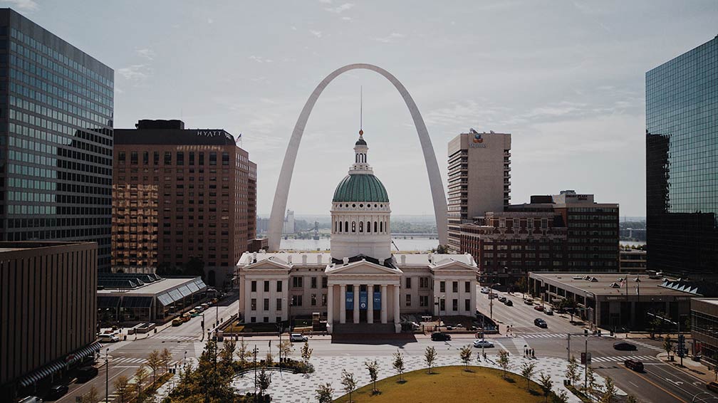
Old County Courthouse and the Gateway Arch in St. Louis, Missouri
Old County Courthouse with the Gateway Arch in St. Louis, Missouri.
Image: Brittney Butler


Other cities and towns in Missouri:
Ava, Bethany, Bolivar, Boonville, Bowling Green, Branson, Brookfield, Butler, Cameron, Cape Girardeau, Carrollton, Carthage, Chillicothe, Clinton, Dexter, Doniphan, Edina, Farmington, Festus, Florissant, Fredericktown, Fulton, Gainesville, Gladstone, Hannibal, Harrisonville, Hermitage, Houston, Joplin, Kennett, Kirksville, Lamar, Lancaster, Lebanon, Lees Summit, Liberty, Macon, Malden, Marshall, Maryville, Mexico, Moberly, Monett, Mountain Grove, Neosho, Nevada, Oakville, Osceola, Park Hills, Perryville, Plattsburg, Poplar Bluff, Princeton, Raytown, Rock Point, Rolla, Salem, Sedalia, Sikeston, St Charles, St Joseph, Sullivan, Trenton, Troy, Van Buren, Vienna, Warrensburg, Warrenton, Washington, West Plains, and Willow Springs.


View from the Liberty Memorial on Downtown Kansas City, Missouri Downtown Kansas City and surroundings, viewed from the Liberty Memorial.
Image: Little Mountain 5


Weather Conditions St. Louis:

SAINT LOUIS WEATHER


Advertisements:


Maps of the 50 U.S. States
Alabama | Alaska | Arizona | Arkansas | California | Colorado | Connecticut | Delaware | Florida | Georgia | Hawaii | Idaho | Illinois | Indiana | Iowa | Kansas | Kentucky | Louisiana | Maine | Maryland | Massachusetts | Michigan | Minnesota | Mississippi | Missouri | Montana | Nebraska | Nevada | New Hampshire | New Jersey | New Mexico | New York | North Carolina | North DakotaOhio | Oklahoma | Oregon | Pennsylvania | Rhode Island | South Carolina | South Dakota | Tennessee | Texas | Utah | Vermont | Virginia | Washington | West Virginia | Wisconsin | Wyoming

20 Most Populous U.S. Cities (in 2018):
1. New York City 2. Los Angeles 3. Chicago 4. Houston 5. Phoenix 6. Philadelphia 7. San Antonio 8. San Diego 9. Dallas 10. San Jose 11. Austin 12. Jacksonville 13. Fort Worth 14. Columbus 15. San Francisco 16. Charlotte 17. Indianapolis 18. Seattle, 19. Denver, 20. Washington D.C.

Other Major U.S. Cities:
Albany, Anchorage, Annapolis, Atlanta, Atlantic City, Augusta, Baltimore, Baton Rouge, Bismarck, Boise, Boston, Carson City, Charleston, WV, Cheyenne, Cincinnati, Cleveland, Columbia, Concord, Des Moines, Detroit, Dover, DE, El Paso, Frankfort, Harrisburg, Hartford, Helena, Honolulu, Jackson, Jefferson City, Juneau, Kansas City, Lansing, Las Vegas, Lincoln, Little Rock, Long Beach, Madison, Memphis, Miami, Milwaukee, Minneapolis, Montgomery, Montpelier, Nashville, New Orleans, Norfolk, Oklahoma City, Olympia, Orlando, Pierre, Pittsburgh, Portland, Providence, Richmond, VA, Raleigh, Sacramento, St. Louis, St. Paul, Salem (OR), Salt Lake City, Santa Fe, Springfield, Tallahassee, Tampa, Topeka, Trenton, Tucson