
| Home |
|
|
|
___ Political Map of Equatorial Guinea |
|
About Equatorial Guinea |
|
| Equatorial Guinea is situated in central West Africa bordering the Bight of Biafra (Atlantic Ocean) between Cameroon and Gabon, it shares maritime borders with Nigeria and São
Tomé and Príncipe. Equatorial Guinea is composed of five inhabited islands plus its part on the African mainland: Río Muni. With an area of 28,000 km² the country is slightly smaller than Belgium or slightly smaller than the U.S. state of Maryland. Pico Basilé (formerly Pico de Santa Isabel) is with 3,011 m (9,879 ft) the highest mountain Equatorial Guinea's, the volcano is located on the island of Bioko. Equatorial Guinea has a population of about 800,000 people (2015), capital city is Malabo, largest city is Bata (pop. 250,000), a port city on the Atlantic Ocean coast of Río Muni. Spoken languages are Spanish, (national), French, and Portuguese. The map shows Equatorial Guinea with surrounding countries, international borders, the national capital Malabo on the island of Bioko (Isla de Bioko, formerly known as Fernando Poo), province capitals, major cities, main roads, and airports. |
 Bookmark/share this page |
 One World - Nations Online All Countries of the World |
|
|
||
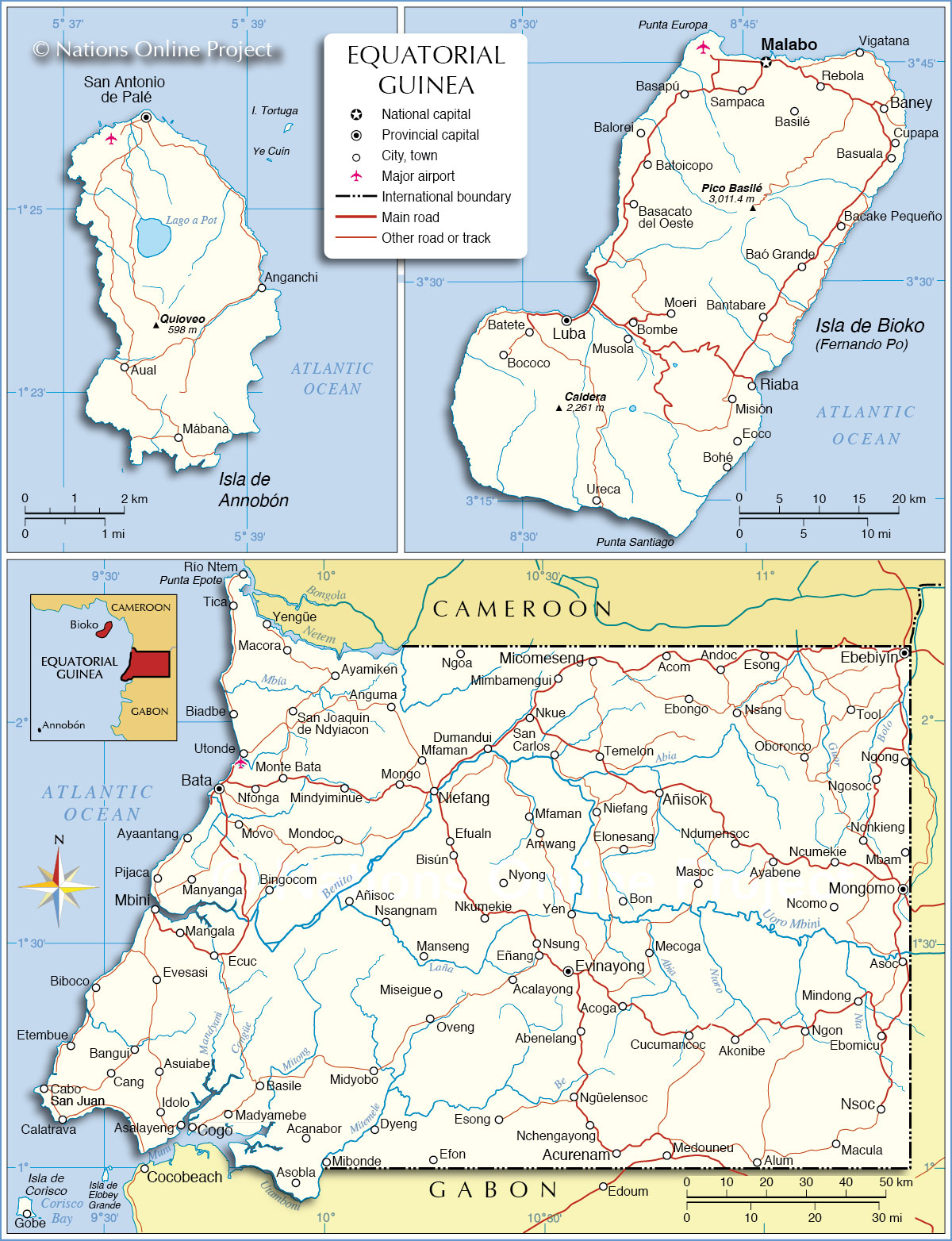 Political Map of Equatorial Guinea Map based on a UN map. Source: UN Cartographic Section |
||
| Cities of Equatorial Guinea The map shows the location of following Equatorial Guinean cities and towns by provinces: |
||
| The Islands: | Río Muni: (on the African mainland) | ||
Annobón (island) San Antonio de Palé, capital of Annobón province other towns and villages: Anganchi, Aual, Mábana Bioko (island) Bioko Norte Malabo is the national capital and the capital of Bioko Norte province other towns and villages: Bacake Pequeño, Balorei, Baney, Basapú, Basilé, Basuala, Cupapa, Rebola, Sampaca, Vigatana |
Bioko Sur Luba, (formerly San Carlos) is the second largest town of Bioko and the capital of Bioko Sur province other towns and villages: Bantabare, Baó Grande, Basacato del Oeste, Batete, Batoicopo, Bococo, Bohé, Bombe, Eoco, Luba, Malabo, Misión, Moeri, Musola, Riaba, and Ureca . |
Litoral Bata, capital of Litoral province other towns and villages: Acanabor, Anguma, Asalayeng, Asobla, Asuiabe, Ayaantang, Ayamiken, Bangui, Basile, Biadbe, Biboco, Bingocom, Cabo, CalatravaIdolo, Cang, Cogo, Dyeng, Ecuc, Etembue, Evesasi, Gobe (on Isla de Corisco), Macora, Madyamebe, Mangala, Manyanga, Mbini, Midyobo, Mindyiminue, Mondoc, Monte Bata, Movo, Nfonga, Pijaca, Río Ntem, San Joaquín de Ndyiacon, San Juan, Tica, Utonde, Yengüe Centro Sur Evinayong is the capital of Centro Sur province other towns and villages: Abenelang, Acalayong, Acoga, Acurenam, Amwang, Añisoc, Bisún, Dumandui, Efon, Efualn, Eñang, Esong, Manseng, Mecoga, Medouneu, Mfaman, Mfaman, Mibonde, Miseigue, Mongo, Nchengayong, Ngoa, Ngüelensoc, Niefang, Nkumekie, Nsangnam, Nsung, Nyong, Oveng, Yen. |
Kié-Ntem Ebebiyín, capital of Kié-Ntem province other towns and villages: Acom, Andoc, Ebongo, Esong, Micomeseng, Mimbamengui, Ngong, Ngosoc, Nkue, Nsang, Oboronco, San Carlos, Tool Wele-Nzas Mongomo, capital of Wele-Nzas province other towns and villages: Akonibe, Alum, Añisok, Asoc, Ayabene, Bon, Cucumancoc, Ebomicu, Elonesang, Macula, Masoc, Mbam, Mindong, Ncomo, Ncumekie, Ndumensoc, Ngon, Niefang, Nonkieng, Nsoc, and Temelon. |
| More about Equatorial Guinea Cities: Country: Continent: |
Explore more
|
Malabo Weather Conditions:
|
Related Consumer Information:
|
||||
| Maps of other Countries in Central Africa Angola Map | Cameroon Map | Central African Republic Map | Chad Map | Republic of the Congo Map Democratic Republic of the Congo Map | Gabon Map |
|||||||
One World - Nations Online .:. let's care for this planet Every nation is responsible for the current state of our world. |
| Site Map
| Information Sources | Disclaimer: Privacy Policy, etc. Contact: [email protected] | Copyright © 1998-2021 :: nationsonline.org |
