Advertising

Alabama Flag detail
Home Earth Continents The Americas USA Country Profile US State Capitals Alabama Map

US States Maps Index
World Maps Index

Map of Alabama (AL)


View of Dauphin Island Bridge across the Gulf Intracoastal Waterway
Dauphin Island Bridge, officially Gordon Persons Bridge, connects Mobile County across the Gulf Intracoastal Waterway with Dauphin Island.
Image: Brian Hancill

Alabama Flag
Alabama State Flag


About Alabama


Location map of Alabama state USA
Where in the United States is Alabama? Location map of the State of Alabama in the US.
 
Alabama is one of the 50 states in the US, located in the southeastern United States between Mississippi and Georgia.

It borders Tennessee in the north along the 35th parallel north, and Florida in the south, a small lobe of Alabama's southwestern land reaches the Gulf of Mexico.


For thousands of years, indigenous peoples had lived along the rivers in what is now Alabama. The first Europeans who visited the area were Spanish explorers in the mid 16th century.

A century and a half later, the country was colonized by settlers from France, who founded the first European settlement in Old Mobile (Fort Louis de La Louisiane).

The region became part of Britain in 1763 and passed to the US in 1783. On 14th December 1819, Alabama became the 22nd state to join the Union.


Alabama State Map

Reference Map of Alabama
General Map of Alabama, United States.

The detailed map shows the US state of Alabama with boundaries, the location of the state capital Montgomery, major cities and populated places, rivers and lakes, interstate highways, principal highways, railroads and major airports.

You are free to use the above map for educational and similar purposes; if you publish it online or in print, you need to credit Nations Online Project as the source.

 
More about Alabama State


Some Geography
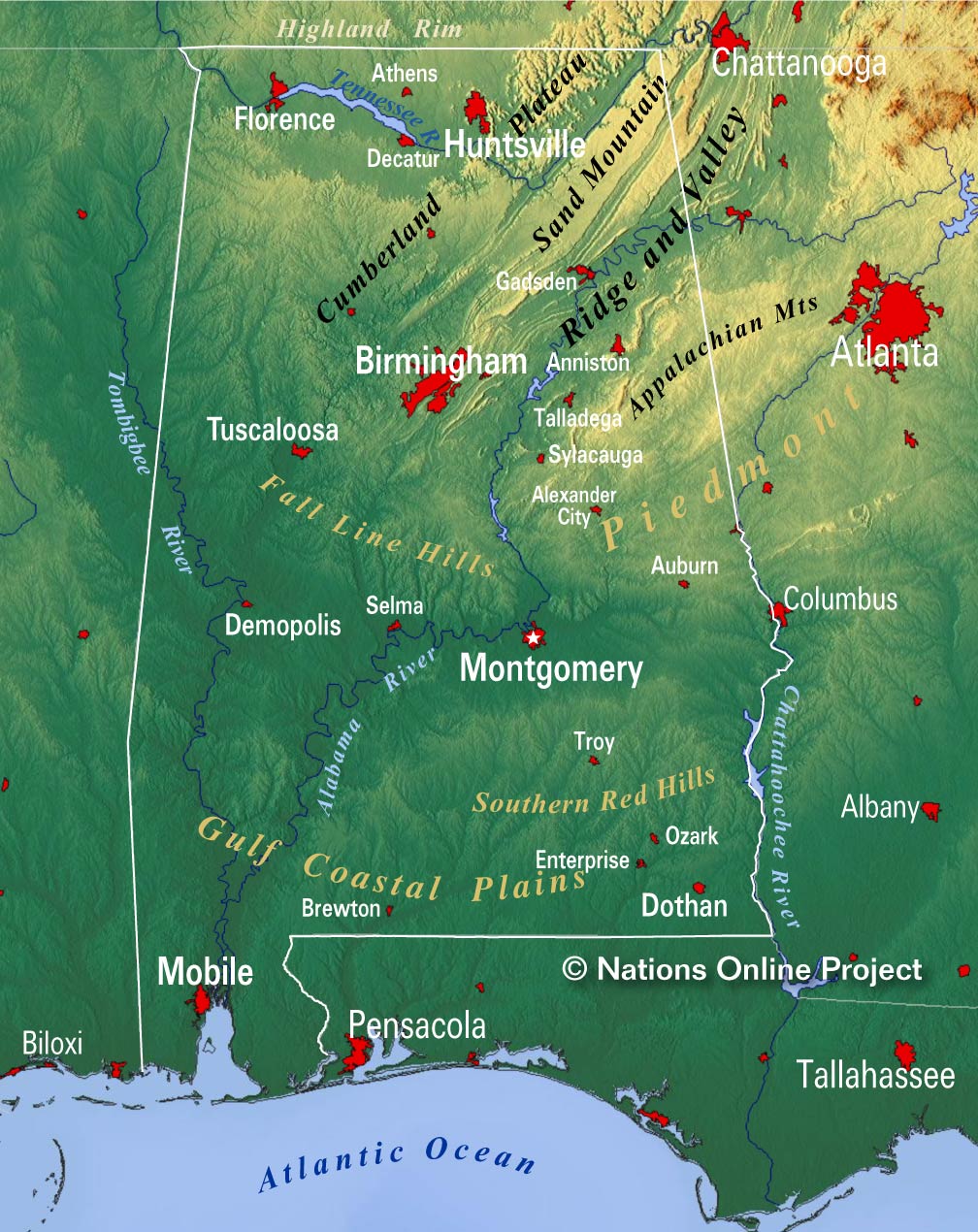
Alabama Topographic Regions Map Topographic Regions Map of Alabama. Click on the map to enlarge.

 
Alabama's landscape is geographically diverse, encompassing coastal plains, rolling hills, and forested areas. Along its southern Gulf Coast, there are sandy beaches and marshy wetlands. Inland, the terrain rises into gently rolling hills, and the northern part of the state is characterized by the foothills of the Appalachian Mountains.
These diverse landscapes offer a range of outdoor opportunities, from water activities along the coast to hiking and exploration in the wooded hills.


Area
The state occupies an area of 135,767 km² (52,420 sq mi), [1] making it somewhat larger than Greece (131,957 km²). Compared with other US states by area, Alabama is six times larger than New Jersey, but it would fit into Texas about five times. Nearly 70% of Alabama's landscape is covered by forest.


Alabama's Landscape
Alabama's landscape offers five major physiographic regions; all areas are sections of the far greater geographic regions of the Eastern and Southeastern United States:


I. The Highland Rim section in the northwest and north-central Alabama is the southern portion of the Appalachian Highlands.


II. To the southeast of the Highland Rim rises the dissected tableland of the Cumberland Plateau (aka Allegheny Plateau), the southern part of the Appalachian Plateau.


III. Further southeast stretches out the belt of the Appalachian Ridge and Valley, a region with ridges along valleys in between, like the Red Mountain ridge that separates the Jones Valley from the Shades Valley south of Birmingham (AL).
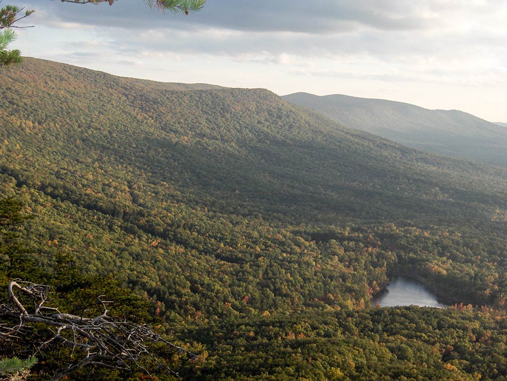

Cheaha Lake at base of Cheaha Mountain, Alabama
Cheaha Lake at base of Cheaha Mountain, highest point in Alabama at 735 m (2,413 ft).
Image: Amann09


IV. Between the Ridge and Valley area and the Atlantic Seaboard fall line dominates the Piedmont Upland Alabama's landscape, a triangular shaped area with rolling hills in the central eastern part of the state.


V. The Coastal Plain province of Alabama is the largest geographic region (about 60%) in the state. It is a mostly flat region, but here and there, it offers some change in the landscape, rounded and eroded hills, cuestas, and Flatwoods; and the are the floodplains of the Alabama and Black Warrior rivers. [2]


Rivers
Principal rivers in Alabama are the Coosa River, which becomes the Alabama River, which is then fed by its tributaries, the Tallapoosa, and the Cahaba rivers.

When the Tombigbee River joins the Alabama, the river changes its name again to Mobile River.

The Tennessee River, the largest tributary of the Ohio River, crosses Alabama in north.

The Chattahoochee River forms a section of Alabama's border with Georgia.

The Black Warrior River empties the largest drainage area that lies entirely within Alabama.


Lakes

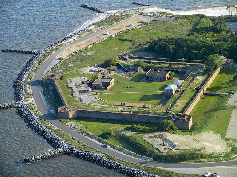
Fort Gaines on Dauphin Island, Alabama
Fort Gaines on Dauphin Island, Alabama. The massive brick fort at the eastern tip of the island was built in the 1820s. It is one of the former three forts that guard the entrance to Mobile Bay.
Image: Edibobb

Major lakes are Lake Guntersville, a reservoir along the Tennessee River; it is Alabama's largest lake.
Wheeler Lake, Alabama's second-largest lake, is a human-made lake along the Tennessee River.
Walter F. George Lake (aka Lake Eufaula) is a reservoir formed on the Chattahoochee River along the state line between Alabama and Georgia.

Lake Martin is a reservoir along the Tallapoosa River, Pickwick Lake is another reservoir along the Tennessee River, and Lewis Smith Lake, a barrier lake on the Sipsey Fork of the Black Warrior River.


Mountains
In the northeastern corner of the state is the Sand Mountain, a sandstone plateau, part of the southern tip of the Appalachian mountain chain. The highest point in Alabama is Mount Cheaha at 735.5 m (2,413 ft), located in Cheaha State Park. [3]


Population


Alabama State Capitol Grounds in Montgomery, the state capital
Rendered image of Alabama State Capitol in Montgomery, the state's capital. The Greek Revival style building houses the Alabama Legislature.
Image: Google


Alabama has a population of 4.9 million people (2019 est.); [4] the state capital and largest city is Montgomery, the second-largest city is industrialized Birmingham.

Other major cities are, Mobile, a major port and the Cotton state's oldest city; Huntsville, Alabama's largest city by land area; and Tuscaloosa, which served as Alabama's capital city from 1826 to 1846.


Ethnic groups
The population of Alabama is composed of white (65%), African-American (27%), Hispanics or Latino (4.6%), and Asian (1.5%). [5]


Cities and Towns in Alabama

The map shows the location of following cities and towns in Alabama:

Largest cities in Alabama with a population of more than 100,000


City of Mobile Alabama, Fort Conde, in background the RSA–Trustmark Building and the Renaissance Mobile Riverview Plaza Hotel
Mobile Alabama. A corner bastion sentry box of Fort Conde, in background the two hotel towers, The Battlehouse in the the RSA–Trustmark Building and the Renaissance Riverview Plaza.
Image: James Willamor

Montgomery (226,000), Birmingham (209,000), Huntsville (199,000), Mobile (189,000), Tuscaloosa (101,100)
(Population figures estimates of 2018)

Other cities and towns in Alabama:

Alexander City, Andalusia, Anniston, Athens, Atmore, Auburn, Bay Minette, Bessemer, Brewton, Butler, Camden, Centreville, Chickasaw, Clanton, Cullman, Daphne, Decatur, Demopolis, Dothan, Elba, Enterprise, Eufaula, Evergreen, Fairfield, Fayette, Florence, Fort Payne, Gadsden, Greenville, Gulf Shores, Guntersville, Haleyville, Hamilton, Hartselle, Homewood, Hoover, Jackson, Jasper, Lanett, Luverne, Madison, Marion, Opelika, Opp, Ozark, Phenix City, Prattville, Prichard, Roanoke, Russellville, Scottsboro, Selma, Sylacauga, Talladega, Thomasville, Troy, Tuscaloosa (fifth most populous city in Alabama with 90,000 people), Tuskegee, and Union Springs.


Airports
The busiest airports in Alabama are

Birmingham–Shuttlesworth International Airport (IATA code: BHM)
Huntsville International Airport (IATA code: HSV)
Mobile Regional Airport (IATA code: MOB)
Montgomery Regional Airport (IATA code: MGM)


Weather Conditions Montgomery:

MONTGOMERY WEATHER


Advertisements:


Maps of the 50 U.S. States
Alabama | Alaska | Arizona | Arkansas | California | Colorado | Connecticut | Delaware | Florida | Georgia | Hawaii | Idaho | Illinois | Indiana | Iowa | Kansas | Kentucky | Louisiana | Maine | Maryland | Massachusetts | Michigan | Minnesota | Mississippi | Missouri | Montana | Nebraska | Nevada | New Hampshire | New Jersey | New Mexico | New York | North Carolina | North DakotaOhio | Oklahoma | Oregon | Pennsylvania | Rhode Island | South Carolina | South Dakota | Tennessee | Texas | Utah | Vermont | Virginia | Washington | West Virginia | Wisconsin | Wyoming

20 Most Populous U.S. Cities (in 2018):
1. New York City 2. Los Angeles 3. Chicago 4. Houston 5. Phoenix 6. Philadelphia 7. San Antonio 8. San Diego 9. Dallas 10. San Jose 11. Austin 12. Jacksonville 13. Fort Worth 14. Columbus 15. San Francisco 16. Charlotte 17. Indianapolis 18. Seattle, 19. Denver, 20. Washington D.C.

Other Major U.S. Cities:
Albany, Anchorage, Annapolis, Atlanta, Atlantic City, Augusta, Baltimore, Baton Rouge, Bismarck, Boise, Boston, Carson City, Charleston, WV, Cheyenne, Cincinnati, Cleveland, Columbia, Concord, Des Moines, Detroit, Dover, DE, El Paso, Frankfort, Harrisburg, Hartford, Helena, Honolulu, Jackson, Jefferson City, Juneau, Kansas City, Lansing, Las Vegas, Lincoln, Little Rock, Long Beach, Madison, Memphis, Miami, Milwaukee, Minneapolis, Montgomery, Montpelier, Nashville, New Orleans, Norfolk, Oklahoma City, Olympia, Orlando, Pierre, Pittsburgh, Portland, Providence, Richmond, VA, Raleigh, Sacramento, St. Louis, St. Paul, Salem (OR), Salt Lake City, Santa Fe, Springfield, Tallahassee, Tampa, Topeka, Trenton, Tucson