Advertising

Kazakhstan Flag detail
Home Earth Continents Asia Kazakhstan Country Profile Kazakhstan Map

Maps

Map of Kazakhstan


Tyuleniy Archipelago with Kulaly Island (left) and Morskoy Island, Kazakhstan
Colorful swirls of the constantly turbid seawater of the shallow Caspian Sea around the Tyuleniy Archipelago with Kulaly Island (left) and Morskoy Island, northwest of Kazakhstan's Tyub-Karagan Peninsula.

Image: NASA

Map of Kazakhstan

Kazakstan Flag
The map shows Kazakhstan, a republic in Central Asia, south of Russia, extending east from the Caspian Sea to the Tian Shan and Altai Mountains and China. Until 1991, Kazakhstan was one of the Soviet republics.

Kazakhstan is a vast country. The region west of the Ural River is considered part of Europe. In the southeast, it is bordered by the Xinjiang Uygur Autonomous Region of China. The easternmost tip of the country is only 38 km (24 mi) from the western border of Mongolia. Other border countries are Kyrgyzstan, Turkmenistan, and Uzbekistan.

An area of 2,724,900 km² makes Kazakhstan the largest landlocked country in the world, even though it has a shoreline at the Caspian Sea but no access to the world's oceans. Compared, Kazakhstan is five times bigger than France, almost the size of Argentina or slightly less than four times the size of the US state of Texas.

The multiethnic country has a population of about 19 million people (in 2021), making it one of the most sparsely populated countries in the world. Vast regions of the territory of the republic are uninhabited.

Since December 1997, the capital of Kazakhstan has been Astana (Астана), which was renamed Nur-Sultan in 2019. Almaty (Алматы), formerly Alma-Ata (Алма-Ата), is the largest city and the former capital of the country. Spoken languages are Kazakh and Russian. The main religion is Islam (70%).


Reference Map of Kazakhstan
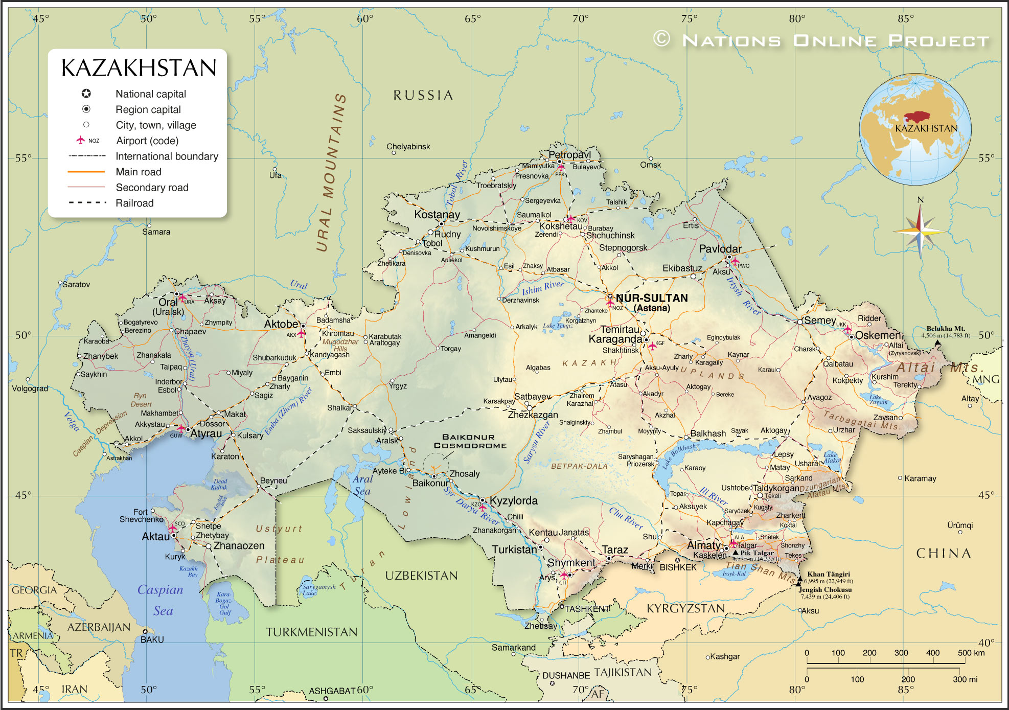
Detailed Map of Kazakhstan

The map shows Kazakhstan and surrounding countries with international borders, the national capital Nur-Sultan (Astana), region capitals, major cities and towns, rivers and lakes, main roads, railroads, and major airports.

You are free to use the above map for educational and similar purposes; if you publish it online or in print, you need to credit Nations Online Project as the source.


More about Kazakhstan


Central Tian Shan mountain range with Khan Tengri and Jengish Chokusu mountains, Kazakhstan and Kyrgyzstan
Central Tian Shan mountain range with the pyramid-shaped mountain Khan Tengri in the center at 6995 m, Kazakhstan's highest peak. The mountain in the foreground left is Jengish Chokusu, the highest mountain in the Tian Shan mountain system at 7,439 m (24,406 ft) sits on the Kyrgyzstan–China border and is Kyrgyzstan's highest peak.
Photo: Chen Zhao

Kazakhstan's Main Geographical Features


Kazakhstan's landscape offers some superlatives: The Kazakh Steppe (Uly Dala), a vast semi-desert region of open grasslands that occupies the northern third of the country, is part of the Eurasian Steppe belt, the largest dry steppe in the world. North and far west of the Kazakh steppe is the ecoregion of the Kazakh forest-steppe, dominated by temperate grasslands, savannas and shrublands.

Situated between the Caspian Sea and Aral Lake is the Ustyurt Plateau, a stony high plain clay desert with eroded hills, shallow basins and extensive escarpments with an average elevation of 150 m.

To the south lies the Turan Lowland, a low-lying desert southeast of the Aral Sea, which extends into Uzbekistan and Turkmenistan. The Turan Lowland lies within the Central Asian desert.

To the west of Lake Balkhash is Betpak-Dala, a flat, gently rolling desert region with many shallow, mostly saline lakes.

In the center of the country lies the Kazakh Uplands, also known as Saryarka or Kazakh hills, a hilly, almost featureless plain that covers most of the Karaganda and parts of the Akmola Regions.
Situated within the Kazakh Uplands is Saryarka, a region known as the Steppe and Lakes of Northern Kazakhstan; the Saryarka is since 2008 a UNESCO World Heritage Site.


Valley of the Castles, a section of the Charyn Canyon in the Almaty Region of Kazakhstan
Valley of the Castles, a section of the Charyn Canyon. The 154 km long canyon on the Sharyn River is part of the Charyn National Park in the Almaty Region.
Photo: Jonas Satkauskas

Kazakh Lakes
Kazakhstan's major lakes are:
The Aral Sea extends over the border between Kazakhstan and Uzbekistan; it is fed by the Syr Darya and the Amu Darya rivers. The Aral Sea was once one of the four largest lakes in the world. The lake has been shrinking steadily since the 1960s, and today it has shrunk to only 10% of its original size due to former Soviet irrigation projects.

Lake Balkhash in the southeast of the country is a large, shallow salt lake fed by five rivers, with most of the inflow coming from the Ili River.

Other lakes are Lake Tengiz, a saline lake and an important wetland site for birds.
Lake Alakol is a salt lake near the Chinese border; it is an important breeding and nesting area for various wetland birds.

Caspian Sea
The Caspian Sea lies between Europe and Asia; it is a sea with no outlet, an endorheic basin, and is known as the world's largest lake. The northeastern part is bounded by Kazakhstan. The Caspian Sea is bordered by four more countries: Turkmenistan, Iran, Azerbaijan, and Russia.
Kazakh Bay is one of the major bays of the Caspian Sea.
Dead Kultuk is a shallow bay of the Caspian Sea with waterlogged marshes further inland and an extension known as the Kaydak Inlet. At the entrance to the bay is an archipelago known for its largest island, Durneva.

Downtown Nur-Sultan (Astana) with Baiterek observation tower.
Central Downtown Nur-Sultan with the Baiterek, a monument and observation tower and a popular tourist attraction in the center.
Photo: Alexei Tarakanov

Mountains
The far east of Kazakhstan is dominated by branches of the Altai and Tian Shan mountain ranges. The country's highest peaks are located there, such as Kazakhstan's highest mountain, the pyramid-shaped Khan Tengri at 6995 m in the central Tian Shan Mountains and the Belukha Mountain at 4,506 m in the Altai Mountains on the Kazakh-Russian border.

Cities
The largest city and the major commercial and cultural center is Almaty, the former capital.
The second-largest city is Nur-Sultan, since 1997 the new capital of Kazakhstan, a planned city named Astana and renamed in 2019 to Nur-Sultan.
Shymkent is a city in the central-southern part of the country in the foothills of the Ugam mountain range with a population of one million people.
Aktobe is located at the confluence of the Kargala and Ilek rivers near the Kazakh-Russian border, northwest of the Aktobe reservoir. The capital of the Aktobe Region has a population of half a million people.
Karaganda (Qaraghandy) is located in the eastern center of the country, north of the Kazakh Uplands, surrounded by a steppe-like landscape and large coal deposits. With 500,882 inhabitants (as of January 2021), it is the fifth-largest city in Kazakhstan.
Taraz is a city on the Talas (Taraz) River near the border with Kyrgyzstan. The capital of the Jambyl Region is one of the oldest cities in Kazakhstan and has a population of about 400,000 people.

Airports
The busiest airports in Kazakhstan

Almaty International Airport (IATA Code: ALA)
Nursultan Nazarbayev International Airport (IATA Code: NQZ)
Aktau Airport (IATA Code: SCO)
Shymkent International Airport (IATA Code: CIT)
ATMA Atyrau Airport (IATA Code: GUW)
Aktobe Airport (IATA Code: AKX)

Cities and towns in Kazakhstan:

The map shows the location of the following Kazak cities and towns:

Akadyr, Akkol, Akkystau, Aksay, Aksu, Aksu-Ayuly, Aksuyek, Aktau, Aktobe, Aktogay, Akzhal, Algabas, Almaty, Altai (Zyryanovsk), Amangeldi, Aralsk, Araltogay, Arkalyk, Arys, Atasu, Atbasar, Atyrau, Auliekol, Ayagoz, Ayteke Bi, Badamsha, Baikonur, Balkhash, Bayganin, Bereke, Berezino, Beyneu, Bogatyrevo, Bulayevo, Burabay, Chapaev, Charsk, Chiili, Denisovka, Derzhavinsk, Dossor, Egindybulak, Ekibastuz, Embi, Ertis, EsbolInderbor, Esil, Fort Shevchenko, Janatas, Kandyagash, Kapchagay, Karabutak, Karagaily, Karaganda, Karaoba, Karaoy, Karaton, Karaul, Karazhal, Karsakpay, Kaskelen, Kaynar, Kentau, Khromtau, Kokpekty, Kokshetau, Koktal, Korgalzhyn, Kostanay, Kugaly, Kulsary, Kurshim, Kuryk , Kushmurun, Kyzylorda, Lepsy, Makat, Makhambet, Mamlyutka, Matay, Merki, Miyaly, Moyynty, Novoishimskoye, Nur-Sultan (Astana), Oral (Uralsk), Oskemen (Ust-Kamenogorsk), Pavlodar, Petropavl, Presnovka , Priozersk, Qalbatau, Ridder, Rudny, Sagiz, Saksaulskiy, Sarkand, Saryözek, Saryshagan, Satbayev, Saumalkol, Sayak, Saykhin, Semey (Semipalatinsk), Sergeyevka, Shakhtinsk, Shalginskiy, Shalkar, Shchuchinsk, Shelek, Shetpe, Shonzhy, Shu, Shubarkuduk, Shymkent, Stepnogorsk, Taipaq, Taldykorgan, Talgar, Talshik, Taraz, Tekeli, Tekes, Temirtau, Terekty, Tobol, Topar, Torgay, Troebratskiy, Turkistan, Ulytau, Urzhar, Usharal, Ushtobe, Yrgyz, Zaysan, Zerendi, Zhairem, Zhaksy, Zhambul, Zhanakala, Zhanakorgan, Zhanaozen, Zhanteke, Zhanybek, Zharkent, Zharly, Zharly, Zhetikara, Zhetisay, Zhetybay, Zhezkazgan, Zhosaly, annd Zhympity.
 

Advertisements:


Weather Conditions Almaty:

ALMATY WEATHER


Advertisements:


Other Countries in Central Asia:
AFG Afghanistan (capital: Kabul) | KGZ Kyrgyzstan (capital: Bishkek) | TJK Tajikistan (capital: Dushanbe) | TKM Turkmenistan (capital: Ashgabat) | UZB Uzbekistan (capital: Tashkent)

Maps of Countries in Central Asia:
Afghanistan Map | Kyrgyzstan Map | Tajikistan Map | Turkmenistan Map | Uzbekistan Map

Map Help [ show ]