Advertising

China Flag detail
Home Earth Continents Asia China Country Profile Map of Southeast Asia

Maps Index

Map of China


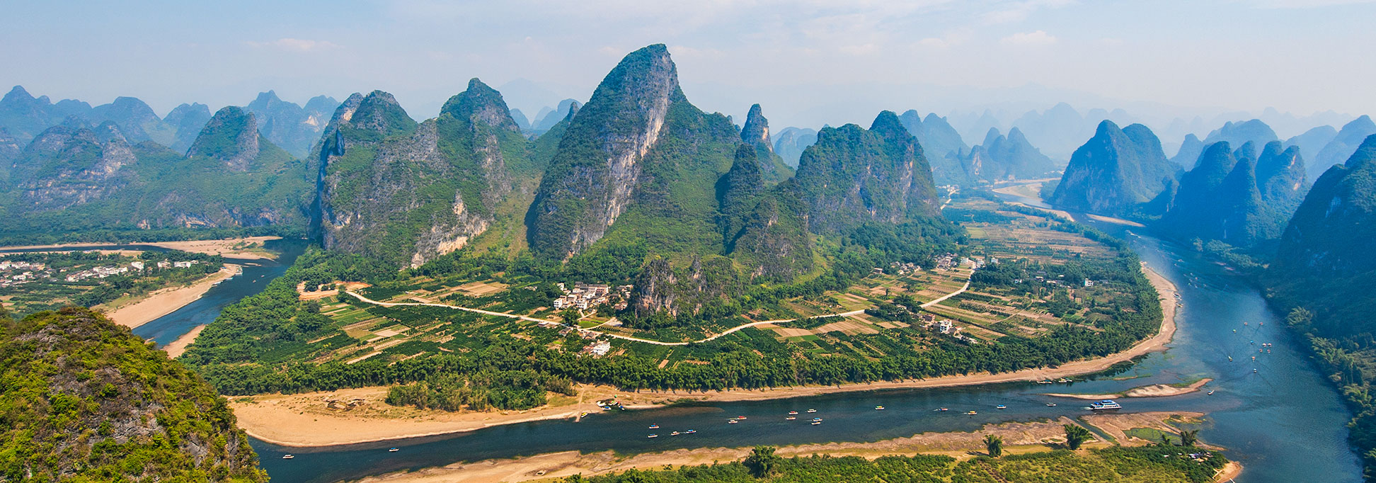
The Li River between Guilin and Yangshuo
The Li River meanders through a dramatic karst landscape in the Guangxi Zhuang Autonomous Region in southwestern China between Guilin and Yangshuo.
Image: Chensiyuan

About China


China Flag
The map shows China, officially the People's Republic of China (PRC), a vast country in East Asia with a 14,500 km (around 9,010 mi) long coastline in the east.

China’s coasts are on the Bohai Sea, the Korea Bay, the East China Sea, the Yellow Sea, and the South China Sea.

The People's Republic borders 14 countries: Afghanistan, Bhutan, India, Kazakhstan, North Korea, Kyrgyzstan, Laos, Mongolia, Myanmar (Burma), Nepal, Pakistan, Russia, Tajikistan, and Vietnam. The country shares maritime borders with Japan, South Korea, the Philippines, and Taiwan. Due to China's claims in the South China Sea, the state also maintains maritime borders that overlap with those of Brunei, Indonesia and Malaysia.

Area
China covers an area of 9,597,000 km²; it is the fourth largest country on Earth. Compared, the People's Republic is somewhat smaller than the United States, or 1.25 times the size of Australia.

Administrative divisions
The country is subdivided into 22 provinces (省).
There are five province-level autonomous regions (自治区); the largest by area are Xinjiang (新疆), Tibet (西藏), and Inner Mongolia (内蒙古). (For more information see also Administrative Map of China)

Population
With a population of about 1.44 billion people (in 2021),[1] China is the world's most populous country.


Map of China

Political Map of China

The map of China shows the People's Republic and neighboring countries with international borders, the national capital Beijing, province capitals, major cities, main roads, railroads, and major airports.

You are free to use the above map for educational and similar purposes; if you publish it online or in print, you need to credit Nations Online Project as the source.


More about China


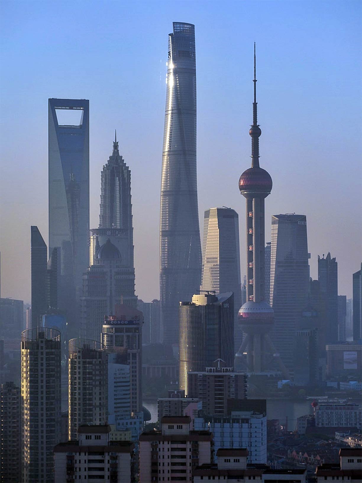
Lujiazui, Shanghai’s new financial district with Shanghai World Financial Center, Jin Mao Tower, Shanghai Tower (the world's second tallest building), and the Oriental Pearl TV Tower
Lujiazui is Shanghai’s new financial district known for its futuristic skyscrapers: (left to right) Shanghai World Financial Center, Jin Mao Tower, Shanghai Tower (the world's second tallest building), and the Oriental Pearl TV Tower. The Huangpu River separates the old financial district of The Bund (Waitan) from Shanghai's new Central Business District.
Photo: Stefan Wagener

 
Size
China is a huge country. It is three times the size of India and larger than the contiguous United States, its population is four times that of the US.

Ethnic Groups
China's population of 1.4 billion people consists of 56 different ethnic groups. By far the largest of these nationalities are the Han people (91%). Han Chinese are the majority in almost every Chinese province except for the autonomous regions of Xinjiang (40%) and the Tibet Autonomous Region (8% ), where Uighurs and Tibetans are the majority, respectively.

Languages
There are about 300 spoken languages in China. Standard Chinese, also known as Modern Standard Mandarin (Putōnghua) is the official language of the People's Republic of China and lingua franca between different ethnic groups.


Climate
China offers the whole range of the Köppen climate. There is the arid cold desert climate in the Uyghur Autonomous Region in the northwest of the country. The alpine tundra-like environment of the Tibetan Plateau has a subarctic climate or a polar tundra climate at altitudes above the tree line. The southeastern portion of China has a mainly temperate climate with dry to wet winters and warm to hot summers. Further south on Hainan Island the climate varies from subtropical to tropical. A humid continental climate predominates the northeast of China, some areas in the far north are subarctic.


Geography
High plateaus with altitudes between 1,000 and 4,000 m cover the western part of the country. The mountain ranges of the Himalayas separating the plains of the Indian subcontinent from the Tibetan Plateau. Within the mountain range is Mount Everest with an elevation of 8,848 m. The international border between Nepal and China runs across the summit of Earth's highest mountain. Jengish Chokusu is the highest mountain in the Tian Shan mountain range at 7,439 m. The Tian Shan range on the border between China and Kyrgyzstan. Kongur Tagh at 7.649 m is the highest mountain entirely within the territory of the Xinjiang Uyghur Autonomous Region.


The map shows the location of following Chinese cities:


Aksu, Altay, Changchun, Changsha, Chengdu, Chongqing, Dali, Dalian, Dongguan, Fuzhou, Golmud, Guangzhou, Guiyang, Haikou, Hailar, Hami, Hangzhou, Harbin, Hefei, Heihe, Hohhot, Hong Kong S.A.R., Hotan, Hunchun, Jilin, Jinan, Jixi, Karamay, Kashgar, Korla, Kunming, Lanzhou, Lhasa, Lianyungang, Lijiang, Macau S.A.R., Nagqu, Nanchang, Nanjing, Nanning, Qamdo, Qingdao, Quanzhou, Shanghai, Shantou, Shenyang, Shenzhen, Shigatse, Shijiazhuang, Taiyuan, Tianjin, Turpan, Ürümqi, Wuhan, Xi'an, Xiamen, Xining, Yantai, Yinchuan, Yining, Yumen, Zhangye, Zhanjiang, and Zhengzhou.

Busiest Airports in China

The busiest airports in China are:
Beijing Capital International Airport (IATA code: PEK)
Shanghai Pudong International Airport (IATA code: PVG)
Shanghai Hongqiao International Airport (IATA code: SHA)
Guangzhou Baiyun International Airport (IATA code: CAN)
Chengdu Shuangliu International Airport (IATA code: CTU)
Shenzhen Bao'an International Airport (IATA code: SZX)
Kunming Changshui International Airport (IATA code: KMG)
Xi'an Xianyang International Airport (IATA code: XIY)
Chongqing Jiangbei International Airport (IATA code: CKG)
Hangzhou Xiaoshan International Airport (IATA code: HGH)
Nanjing Lukou International Airport (IATA code: NKG)
Zhengzhou Xinzheng International Airport (IATA code: CGO)
Xiamen Gaoqi International Airport (IATA code: XMN)
Changsha Huanghua International Airport (IATA code: CSX)
Qingdao Liuting International Airport (IATA code: TAO)

Advertisements:


Weather Conditions Beijing:

BEIJING WEATHER


Advertisements:


Maps of other countries in Southeast and Eastern Asia:
Bangladesh Map, Bhutan Map, Cambodia Map, India Map, Indonesia Map, Japan Map, Korea (North), Korea (South), Laos Map, Malaysia Map, Maldives Map, Mongolia Map, Myanmar Map, Nepal Map, Pakistan Map, Philippines Map, Singapore Map, Sri Lanka Map, Taiwan Map, Thailand Map, Vietnam Map