
|
Home |
|
|
|
___ Political Map of Djibouti |
|
The Map is showing Djibouti, a country on the northeastern coast of Africa to the Red Sea and the Gulf of Aden. It is bordered by Eritrea, Ethiopia, and Somalia. Depicted on the map is Djibouti and the surrounding countries with international borders, the national capital Djibouti (city), districts and district capitals, major cities and towns, main roads, airports and airstrips. |
 Bookmark/share this page |
 One World - Nations Online countries of the world |
|
|
||
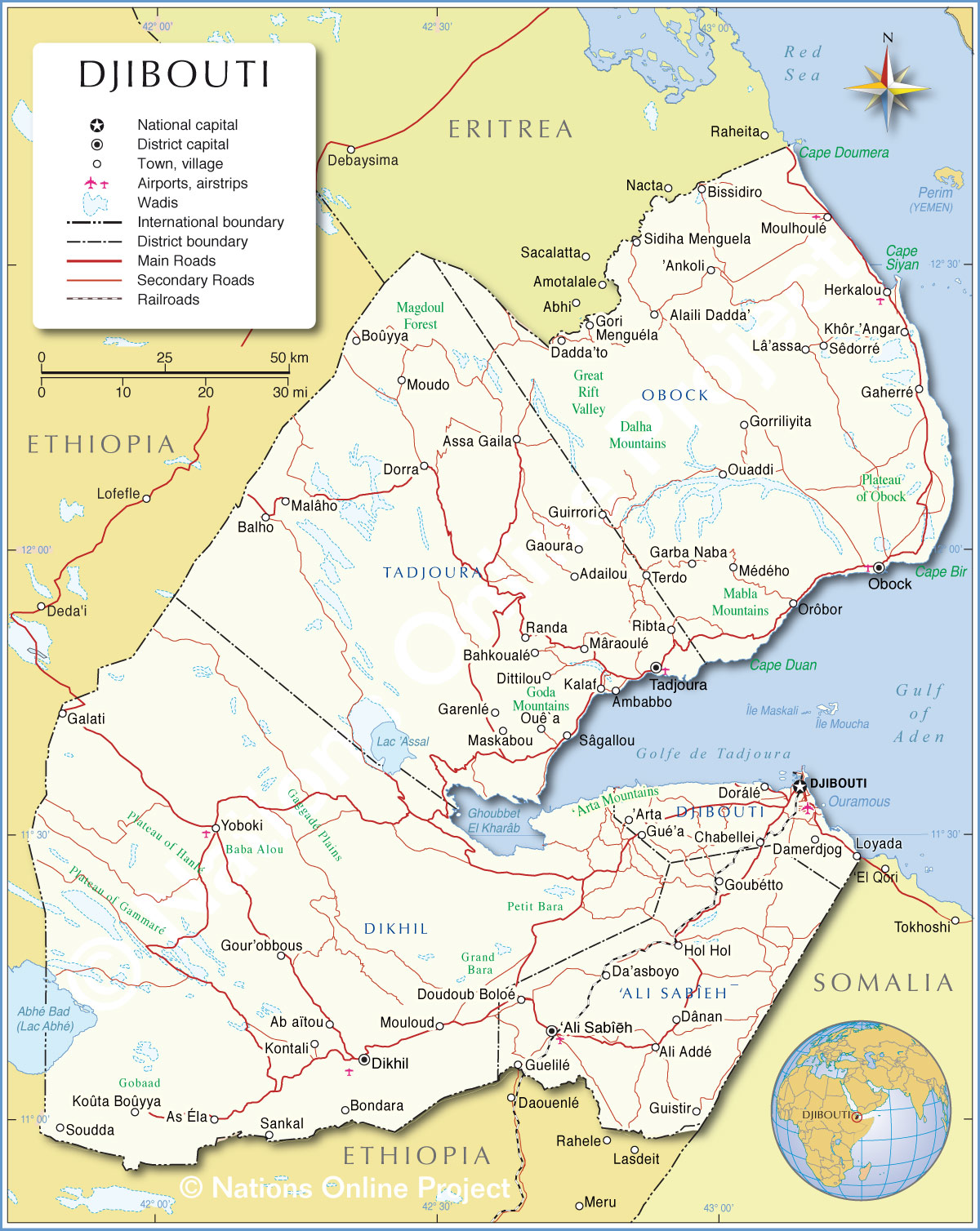 Political Map of Djibouti Map based on a UN map. Source: UN Cartographic Section | |||||||
| Cities in Djibouti: The map shows the location of following cities and towns in Djibouti: Ab aïtou, Adailou, Alaili Dadda’, Ali Addé‘, Ali Sabî, Ankoli, ’Arta, As Éla, Assa Gaila, Bahkoualé, Balho, Bissidiro, Bondara, Boûyya, Chabellei, Da’asboyo, Dadda’to, Damerdjog, Dânan, Deda'i, Dittilou, Dorálé, Dorra, Doudoub Boloé, Gaherré, Galati, Gaoura, Garba Naba, Garenlé, Gori , Gorriliyita, Goubétto, Gour’obbous, Guelilé, Gué’a, Guirrori, Guistir, Herkalou, Hol Hol, Kalaf, Khôr ’Angar, Kontali, Koûta Boûyya, Lâ’assa, Malâho, Maskabou, Mâraoulé, Menguéla, Médého, Moudo, Moulhoulé’, Mouloud, Ouaddi, Ouê a, Randa, Ribta, Sankal, Sêdorré, Sidiha Menguela, Soudda, Terdo, and Yoboki. |
More about Djibouti: Cities: Country: Continent: |
Current Weather Conditions Djibouti City
|
Related Consumer Information:
|
||||
Maps of other Countries in East Africa Burundi Map | Comoros Map | Djibouti Map | Eritrea Map | Ethiopia Map | Kenya Map Madagascar Map | Malawi Map | Mozambique Map | Réunion Map | Rwanda Map | Somalia Map | Tanzania Map Uganda Map | Zambia Map | Zimbabwe Map Interactive Maps of other Countries in East Africa Burundi Interactive Map | Comoros Interactive Map | Djibouti Interactive Map | Eritrea Interactive Map Ethiopia Interactive Map | Kenya Interactive Map | Madagascar Interactive Map | Malawi Interactive Map Mauritius Interactive Map | Mozambique Interactive Map | Réunion Interactive Map | Rwanda Interactive Map Seychelles Interactive Map | Somalia Interactive Map | Tanzania Interactive Map | Uganda Interactive Map Zambia Interactive Map | Zimbabwe Interactive Map Major Cities in East Africa Addis Ababa, Antananarivo, Asmara, Bujumbura, Dar es Salaam, Djibouti, Dodoma, Harare, Kampala, Kigali, Lilongwe, Lusaka, Maputo, Moroni, Mogadishu, Nairobi, Port Louis, Victoria, Zanzibar |
|||||||
One World - Nations Online .:. let's care for this planet Every nation is responsible for the current state of our world. |
| Site Map
| Information Sources | Disclaimer: Privacy Policy, etc. Contact: [email protected] | Copyright © 1998-2021 :: nationsonline.org |
