Nations Online
All Countries in the World
Nations Online All Countries in the World | |
Home  |
___ Searchable Map and Satellite View of the City of Tucson, Arizona (45-degree view available) |
About Tucson |
 Satellite view showing Tucson, a major city in the State of Arizona in the Satellite view showing Tucson, a major city in the State of Arizona in the 1775 is the official birthdate of Tucson. The City was then part of Mexico. In 1854, Tucson came under the jurisdiction of the United States when Southern Arizona was legally bought from Mexico. In 1863 Arizona became an official territory of the US and Tucson was the territorial capital between 1867 and 1877. 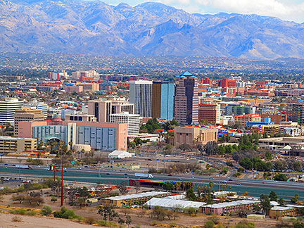 View of Tucson from Sentinel Peak. Image: John Diebolt The city is home to the University of Arizona and its Arizona Museum of Art, and the Museum of Contemporary Arts, MOCA. The city's economy is based on arts, high-tech industries, manufacturing, services and tourism. Biggest employers are the University of Arizona and Davis-Monthan Air Force Base. Local attractions are: the Sentinel Peak or 'A' Mountain, Arizona-Sonora Desert Museum and Tucson Desert Art Museum, the Pima Air & Space Museum, Mission San Xavier del Bac, the Tucson Botanical Gardens, and Saguaro National Park. The page shows a city map of Tucson with expressways, main roads and streets, zoom out to find Tucson International Airport (IATA code: TUS) located in south. Just zoom in to see Downtown Tucson. To find a location use the form below. To view just the map, click on the "Map" button. |
|
| To find a location type: street or place, city, optional: state, country. |
Local Time Tucson:
Friday-June-26 09:30
Standard time zone: MST - Mountain Standard Time; UTC/GMT -7 hoursArizona does not observe daylight saving time. |
One World - Nations Online .:. let's care for this planet Promote that every nation assumes responsibility for our world. Nations Online Project is made to improve cross-cultural understanding and global awareness. More signal - less NOISE |
| Site Map
| Information Sources | Disclaimer | Copyright © 1998-2024:: nationsonline.org |

