Nations Online
All Countries in the World
Nations Online All Countries in the World | |
Home  |
___ Satellite View and Map of the City of Bucharest (Bucureşti) |
| (with 45-degree image coverage) |
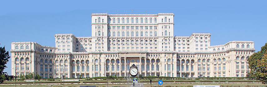 Palace of the Parliament of Romania in Bucharest, it is the World's largest administrative building. Image: Antony Stanley |
About Bucharest Satellite view is showing Bucharest, largest city and the national capital of Satellite view is showing Bucharest, largest city and the national capital of Bucharest is the country's industrial and financial center and a major transportation hub in Eastern Europe. It is also the center of Romanian media, culture and art, home to the National Museum of Art and the National Library of Romania. Bucharest is seat of the Romanian Government and has a population of about 2 million inhabitants (2013). 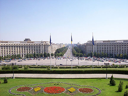 Boulevard Unirii seen from the Palace of the Parliament. Palace of the Parliament (seat of the Romanian Parliament), Romanian Athenaeum (concert hall), Herăstrău Park (park and lake), National Village Museum (open-air museum about traditional Romanian village life), Museum of the Romanian Peasant (textiles, icons, ceramics), National Museum of Natural History (natural history), National Museum of Romanian History (Romanian history), National Museum of Art of Romania (collections of medieval and modern Romanian art), National Museum of Contemporary Art (contemporary art), National Geology Museum (rocks, fossils, and minerals), Cotroceni Palace (residence of the Romanian President), Curtea Veche (princely residence of Vlad III Dracul), Romanian Patriarchal Cathedral (Romanian Orthodox Church), Bucharest Botanical Garden (flowers and trees), Tineretului Park (public park), Jewish Museum (history of the Jews in Romania), Pasajul Macca-Vilacrosse (glass covered arcaded street) Just zoom in (+) to see the Palace of the Parliament, the world's largest civilian administrative building. The Map shows a city map of Bucharest with expressways, main roads, and streets, as well as the location of Aurel Vlaicu International Airport (IATA code: BBU), zoom out to find Henri Coandă International Airport (IATA code: OTP) also known as Bucharest Otopeni International, located in Otopeni in a distance of 16.5 km (10.3 mi) north of Bucharest. To find a location use the form below. |
|
| To find a location type: street or place, city, optional: state, country. |
Local Time Bucharest:
Sunday-June-21 12:41
Standard Time Zone (EET): UTC/GMT +2 hoursDaylight Saving Time in use from end of March until end of October: time zone offset: UTC/GMT +3 hours |
|
φ Latitude, λ Longitude (of Map center; move the map to see coordinates): , |
||||||
| Google Map: Searchable map/satellite view of Bucharest (Harta orasului Bucuresti), Romania City Coordinates: 44°25′57″N 26°6′14″E |
Bookmark/share this page |
|||||
| More about Romania: Cities: Country: Continent: Political Map of the Balkans. External Links: Bucharest Official website of the City of Bucharest (in Romanian). Tourism Bucharest Romanian National Tourist Office with information about Bucharest. Wikipedia: Bucharest Wikipedia article about Bucharest |
Weather Conditions Bucharest
|
Explore more:
Related Consumer Information:
|
||||
Other Cities on the Balkan Peninsula Athens, Belgrade, Istanbul, Ljubljana, Podgorica, Skopje, Sarajevo, Sofia, Tirana, Zagreb Other Cities in Eastern Europe: Bratislava | Budapest | Chisinau | Kiev | Minsk | Moscow | Odessa | Prague | Riga Sofia | Sevastopol (Crimea) | Tallinn | Warsaw | Vilnius Maps of other countries and regions in Central and Eastern Europe Belarus Map, Bulgaria Map, Czech Republic Map, Hungary Map, Moldova Map, Poland Map, Romania Map, Slovakia Map, Ukraine Map Administrative Maps of other countries and regions in Central and Eastern Europe Hungary Administrative Map, Poland Administrative Map, Ukraine Administrative Map Interactive Maps of other countries and regions in Central and Eastern Europe Belarus Interactive Map, Bulgaria Interactive Map, Czech Interactive Republic Map, Hungary Interactive Map, Moldova Interactive Map, Poland Interactive Map, Slovakia Interactive Map, Ukraine Interactive Map |
||||||
Map Help [ show ] |
||||||
One World - Nations Online .:. let's care for this planet Promote that every nation assumes responsibility for our world. Nations Online Project is made to improve cross-cultural understanding and global awareness. More signal - less NOISE |
| Site Map
| Information Sources | Disclaimer | Copyright © 1998-2024:: nationsonline.org |

