
One World
Nations Online
Countries in the World
 |
|
 One World Nations Online Countries in the World | |
Home  |
___ Satellite View and Map of the City of Madrid, Spain (45-degree view available) |
 Palacio Real, the Royal Palace of Madrid, it is the official residence of the Spanish Royal Family, but the royal facility is only used for state ceremonies and the like. Image: Gryffindor |
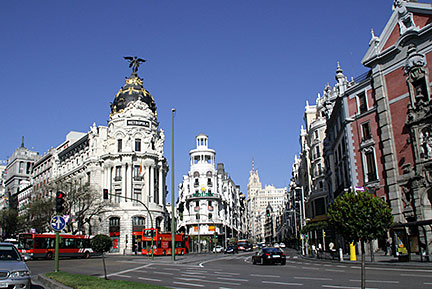
About Madrid Satellite view is showing Madrid, largest city, capital of the autonomous community of Madrid, economical and political center and the national capital of Satellite view is showing Madrid, largest city, capital of the autonomous community of Madrid, economical and political center and the national capital of The city is located on a high plateau in the center of the country at the Manzanares river. In Madrid's metropolitan area (urban area and suburbs) there live almost 6 million people.  View from Calle de Alcalá street in Madrid, at the left, Metropolis Building (Edificio Metrópolis). At the center, the beginning of the Gran Vía, an upscale shopping street in central Madrid with a vivid nightlife. Image: Fermín Rodríguez Fajardo The city is home to a large number of public and private universities. Complutense University of Madrid, established in 1293, is one of the oldest universities in the world. Madrid is also home to Real Madrid football club, one of the best known and the most valuable sports team in the world. They own the Santiago Bernabéu Stadium, an all-seater football stadium in Madrid. The map shows a city map of Madrid with expressways, main roads and streets, zoom out to find the location of Madrid Barajas International Airport (IATA code: MAD) 15.3 km (9.5 mi) by road (via M-40) northeast of the city center. To find a location use the form below. To view the map, click on the "Map" button. |
|
| To find a location type: street or place, city, optional: state, country. |
Local Time Madrid:
Wednsday-April-24 13:19
Standard Time Zone (CET): UTC/GMT +1 hourCEST (Daylight Saving Time) in use from end of March until end of October. Time zone offset: UTC/GMT +2 hours |
|
φ Latitude, λ Longitude (of Map center; move the map to see coordinates): , |
||||||
| Google Maps: Searchable map/satellite view of Madrid, Kingdom of Spain. City Coordinates: 40°23′N 3°43′W |
Bookmark/share this page
|
|||||
| More about Spain: Cities: Country: Key statistical data of Spain. Continent: Political Map of the Mediterranean Region. Political Map of the Balkans. External Links: Madrid (official web site) Madrid-Barajas Airport Wikipedia: Madrid |
Weather Conditions Madrid: |
Explore more:
Related Consumer Information:
|
||||
Europe's Alpha Cities: Rome - Zürich - Madrid - Paris - Amsterdam London - Stockholm - Berlin - Prague - Vienna - Istanbul Cities in the Mediterranean Athens, Barcelona, Florence, Istanbul, Lisbon, Ljubljana, Monaco, Milan, Naples, Rome, San Marino, Tirana, Valletta, Vatican City, Venice, Zagreb, Alexandria, Algiers, Beirut, Benghazi, Cairo, Jerusalem, Nicosia, Tripoli, Tunis, Tel Aviv Maps of other Countries in Southern Europe Croatia Map, Cyprus Map, Greece Map, Italy Map, Macedonia Map, Vatican City State Map Montenegro Map, Portugal Map, Serbia Map, Slovenia Map, Spain Map, Turkey Map Searchable Maps of other Countries in Southern Europe Croatia, Cyprus, Greece, Italy, Macedonia, Vatican City State Montenegro, Portugal, Serbia, Slovenia, Spain, Turkey Profiles of other Countries in Southern Europe Croatia, Cyprus, Greece, Italy, Macedonia, Vatican City State Montenegro, Portugal, Serbia, Slovenia, Spain, Turkey |
||
Map Help [ show ]  |
||
One World - Nations Online .:. let's care for this planet Promote that every nation assumes responsibility for our world. Nations Online Project is made to improve cross-cultural understanding and global awareness. More signal - less NOISE |
| Site Map
| Information Sources | Disclaimer | Copyright © 1998-2023 :: nationsonline.org |