Nations Online
All Countries in the World
Nations Online All Countries in the World | |
Home  |
___ Satellite View and Map of the City of Riga, Latvia |
About Riga Satellite view is showing Riga, a seaport, largest city and the national capital of Satellite view is showing Riga, a seaport, largest city and the national capital of The city is located at a sheltered natural harbour of the Daugava river, 15 km upstream from its estuary mouth to the Baltic Sea. The Daugava river has been a trade route since ancient times. During the early Middle Ages Riga developed to a center of trade with the Vikings, the Germanic Norse seafarers. Riga became a Hanseatic city in 1282, one of the cities of the Hanseatic League, the mercantile and military alliance of German-dominated cities in Northern Europe. Today Riga is the largest city in the Baltic states and Latvia's primate city, it is the financial, political, and population center of the country, and a major commercial, cultural, and political hub in the Baltics. Riga Port is one of the major ports in the Baltics. The city has a population of about 700,000 inhabitants, 1 million people live in its metropolitan area (Riga Region), this is half of Latvia's population. Spoken languages are Latvian (official), Russian, and Lithuanian. The Historic Centre of Riga is a UNESCO World Heritage Site. The city was the European Capital of Culture during 2014. The map shows a city map of Riga with expressways, main roads and streets, and the location of Riga International Airport To find a location use the form below. |
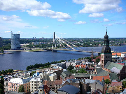 View of Riga's Old Town with Dome Cathedral, Vanšu bridge spanning the Daugava river in background. Image: Véronique Dauge © UNESCO Bookmark/share this page |
| To find a location type: street or place, city, optional: state, country. |
Local Time Riga:
Monday-June-22 09:20
Time zone: Eastern European Time (EET) :: UTC/GMT +2 hoursDaylight saving time from end of March until end of October UTC/GMT +3 hours. |
One World - Nations Online .:. let's care for this planet Promote that every nation assumes responsibility for our world. Nations Online Project is made to improve cross-cultural understanding and global awareness. More signal - less NOISE |
| Site Map
| Information Sources | Disclaimer | Copyright © 1998-2024:: nationsonline.org |

