Nations Online
All Countries in the World
Nations Online All Countries in the World | |
Home  |
___ Satellite View and Map of the City of Podgorica (Подгорица), Montenegro |
About Podgorica Satellite view is showing Podgorica, largest city and the national capital of Satellite view is showing Podgorica, largest city and the national capital of The city is located at the site where the small Ribnica river joins the Morača river, in the southeastern part of the country, about 50 km from the Mediterranean coast. It is Montenegro’s primate city and the administrative, economic, and cultural center of the country. 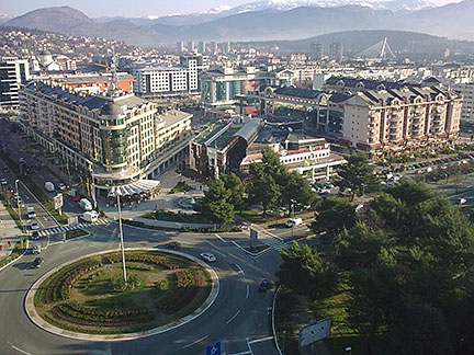 Podgorica city center as seen from the top of Atlas Capital Center with the Millenium Bridge in background. Image by: Nije bitno (It does not matter ;) Spoken language is the Montenegrin language, Montenegro's primary official language but still more people speak Serbian. Podgorica is the administrative, economical and educational center of Montenegro. The city is home to the University of Montenegro and most of Montenegro's higher education institutions are located in here, as well as most of Montenegro's industrial, financial, and commercial corporations are based in Podgorica. The map shows a city map of Podgorica with expressways, main roads and streets, zoom out to find the location of Podgorica Airport To find a location use the form below. |
|
| To find a location type: street or place, city, optional: state, country. | Local Time Montenegro:
Friday-June-26 16:02
Standard Time Zone (CET): UTC/GMT +1 hourCEST (Daylight Saving Time) in use from end of March until end of October. Time zone offset: UTC/GMT +2 hours |
One World - Nations Online .:. let's care for this planet Promote that every nation assumes responsibility for our world. Nations Online Project is made to improve cross-cultural understanding and global awareness. More signal - less NOISE |
| Site Map
| Information Sources | Disclaimer | Copyright © 1998-2024:: nationsonline.org |

