Advertising

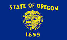
Oregon Flag detail
Home Earth Continents The Americas USA Country Profile US State Capitals Oregon Map

US States Maps Index
World Maps Index

Map of Oregon (OR)


Crater Lake Oregon seen from Watchman Overlook
View of Crater Lake from Watchman Overlook. The caldera lake is situated in Crater Lake National Park in the Cascade Mountains. Wizard Island, a cinder cone, is in the center. Crater Lake is the deepest lake in the United States and one of the deepest in the world with a depth of 594 meters (1,949 ft).
Image: Athleticamps


Oregon Flag
Oregon State Flag


About Oregon


Location map of Oregon state USA
Where in the United States is Oregon? Location map of Oregon in the US.
 
Oregon, one of the 50 US states, is situated in the north-western United States. It is one of just three US states in the contiguous United States with a coastline at the Pacific Ocean.

The Colombia River largely defines Oregon's border with Washington state in the north; the Snake River forms a section of its state line with Idaho in the east, and the 42nd parallel north defines the borders with California and Nevada in the south.


In 1842–43, the Oregon Trail brought many new settlers to the Oregon Country. British claims to the territory were formally ceded to the US in 1846 and Oregon became the 33rd state on 14th February 1859.


Oregon State Map
Reference Map of Oregon
General Map of Oregon, United States.

The detailed map shows the State of Oregon with boundaries, the location of the state capital Salem, major cities and populated places, rivers and lakes, interstate highways, principal highways, railroads and major airports.

You are free to use the above map for educational and similar purposes; if you publish it online or in print, you need to credit Nations Online Project as the source.

 
More about Oregon State


Area
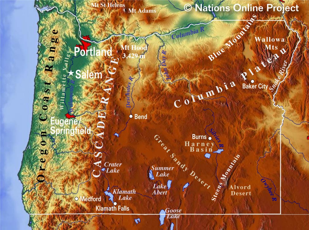
Oregon Topographic Regions Map
Topographic Map of Oregon showing the location of the Cascades, the Columbian Plateau, the Harney Basin, the Alvord Desert, Steens Mountain, Crater Lake, and the Oregon Coast Range. (click map to enlarge)
 
The Beaver State (Oregon's nickname) occupies an area of 254,800 km² (98,379 sq mi) [1], compared Oregon is slightly larger than the United Kingdom. Compared with other US states, New Jersey would fit into Oregon 11 times.


Landscape
Oregon has some amazing geographical features. There are the Wallowa Mountains and the Blue Mountains of the Pacific Northwest situated in the northeastern corner of Oregon. Within the area are the Umatilla and the Wallowa-Whitman National Forests.

The Cascade Range dominates the eastern third of Oregon. The chain of mountains runs from British Columbia in the north, through Washington State and Oregon, to Northern California in the south. It is in large parts a densely wooded mountain range interspersed with half a dozen of Quaternary volcanoes in the High Cascades. The mountains are a section of the American Cordillera and impressive hot spots within the Pacific Ocean's Ring of Fire.

The Cascades are home to three National Forests. Around Mount Hood, a dormant stratovolcano is the Mount Hood National Forest. The Willamette National Forest, the vast national forest along the western slopes of the Cascade Range comes with eight wilderness areas, including the Three Sisters Wilderness and Mt. Jefferson Wilderness. The Umpqua National Forest in the southern Cascade Range is home to the deepest lake in the United States, the Crater Lake, formed by the collapse of the Mount Mazama volcano 7,000 years ago.


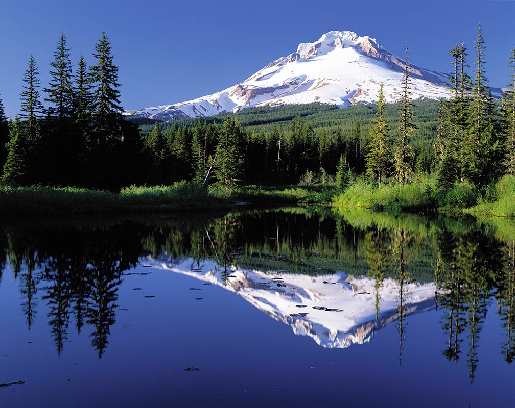
 Mount Hood reflected in Mirror Lake, Oregon
Mount Hood reflected in Mirror Lake. The stratovolcano is the highest mountain in Oregon.
Image: FHWA

Parallel to the Cascades to the west is the Oregon Coast Range running along the Pacific Ocean.
The mountain range separates the Willamette Valley from Oregon's coast. The valley is the site of most of Oregon's population; it extends from Portland in the north to Eugene in the south.

The mountain chain is part of a larger series of mountain ranges known as the Pacific Mountain System that extends over much of the western edge of North America.

The Harney Basin, an endorheic basin (without a water outlet) in the southeast of Oregon, is part of the much larger Great Basin (Great Basin Desert), which covers most of Nevada, parts of Utah, Wyoming, Idaho, California, and the Mexican state of Baja California. The Harney Basin is bordered in west and south by the Great Sandy Desert, the Steens Mountain in the southeast. The ridge of the mountain separates the basin from the Alvord Desert to the southeast.

 
Highest Point in Oregon
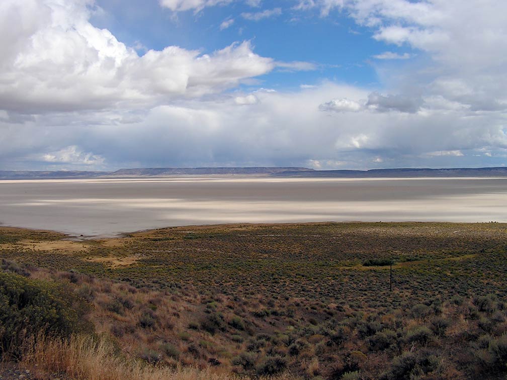
Alvord Desert in south eastern Oregon
Alvord Desert in south eastern Oregon is one of the largest dry lakes (playa) in Oregon. The darker areas are cloud shadows.
Image: Sosobra
 

The highest peak in the state is Mount Hood (3,428.8 m or 11,249 ft), a potentially active stratovolcano in the Cascade Volcanic Arc.
In the southeastern corner of Oregon is Steens Mountain, an 80 km (50 mi) long fault-block mountain rising from the Alvord Desert to a hight of 2,968 m at its peak.


The Alvord Desert is a desert landscape east of the Pueblo Mountains and the Steens Mountain at an elevation of approximately 1,200 m (4,000 ft); the desert is among the largest dry lakes (playa) in Oregon.
Playa lakes are formed when rainwater fills shallow depressions in the landscape; when the water evaporates, it leaves minerals behind. During the dry season, the ground is flat enough to drive over with a car or land small planes on it.


Population

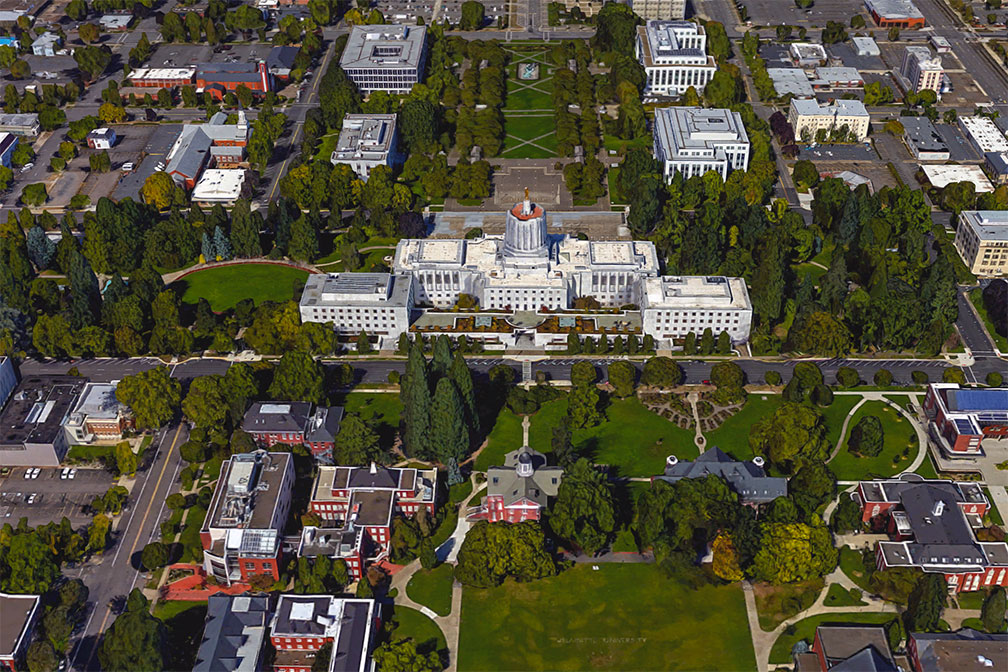
Oregon State Capitol in Salem, Oregon
Rendered image of Oregon State Capitol in Salem, the state capital. The Art Deco building is home to the state legislature and the offices of the governor of Oregon.
Image: Google

Oregon has a population of 4.2 million people (2019 est.) [2]; the capital is Salem and the largest city is Portland, a major river port. The largest metropolitan area is Portland metro with a population of 2.4 million people.

Almost 70% of Oregon's population lives in the Willamette Valley, one of the most fertile agricultural landscapes in the world.

Race and Ethnic groups
Oregon's population is 87% white, 13.4% Hispanic or Latino, 5% Asian, 2.2% African American, and 1.8% Native American. [3]

Cities and Towns in Oregon

The map shows the location of following cities and towns in Oregon:


The 10 largest Cities in Oregon

Portland (653,000)
Salem (173,000)
Eugene (171,000)
Gresham (110,000)
Hillsboro (108,000)
Beaverton (99,000)
Bend (97,600)
Medford (82,000)
Springfield (63,000)
Corvallis (58,600)
Source: Population figures in 2018


Other cities and towns in Oregon:
Albany, Ashland, Astoria, Baker City, Bly, Brookings, Burns, Canyon City, Condon, Coos Bay, Enterprise, Florence, Grants Pass, Hermiston, John Day, Jordan Valley, Keizer, Klamath Falls, La Grande, Lakeview, Madras, McMinnville, Newport, North Bend, Ontario, Pendleton, Port Orford, Prineville, Redmond, Reedsport, Roseburg, Seaside, St Helens, The Dalles, Tillamook, and Vale.

Airports
The largest airport in the state is Portland International Airport (IATA code: PDX). Other major airports are Eugene Airport (Mahlon Sweet Field; IATA code: EUG), Rogue Valley International-Medford Airport (IATA code: MFR), and Redmond Municipal Airport (Roberts Field; IATA code: RDM).
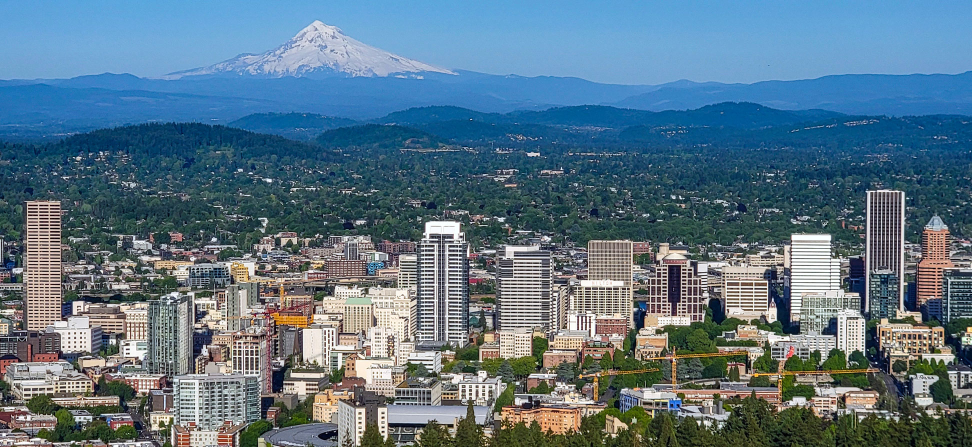

Skyline of Portland seen from Pittock Mansion
The skyline of Portland seen from Pittock Mansion; with Mt. Hood, a potentially active stratovolcano, in the background. The port city is Oregon's largest urban center; 2.4 million people live in its metropolitan area. Portland is known for its vivid music scene.
Image: Truflip99
 

Weather Conditions Portland:

PORTLAND WEATHER


Advertisements:


Maps of the 50 U.S. States
Alabama | Alaska | Arizona | Arkansas | California | Colorado | Connecticut | Delaware | Florida | Georgia | Hawaii | Idaho | Illinois | Indiana | Iowa | Kansas | Kentucky | Louisiana | Maine | Maryland | Massachusetts | Michigan | Minnesota | Mississippi | Missouri | Montana | Nebraska | Nevada | New Hampshire | New Jersey | New Mexico | New York | North Carolina | North DakotaOhio | Oklahoma | Oregon | Pennsylvania | Rhode Island | South Carolina | South Dakota | Tennessee | Texas | Utah | Vermont | Virginia | Washington | West Virginia | Wisconsin | Wyoming

20 Most Populous U.S. Cities (in 2018):
1. New York City 2. Los Angeles 3. Chicago 4. Houston 5. Phoenix 6. Philadelphia 7. San Antonio 8. San Diego 9. Dallas 10. San Jose 11. Austin 12. Jacksonville 13. Fort Worth 14. Columbus 15. San Francisco 16. Charlotte 17. Indianapolis 18. Seattle, 19. Denver, 20. Washington D.C.

Other Major U.S. Cities:
Albany, Anchorage, Annapolis, Atlanta, Atlantic City, Augusta, Baltimore, Baton Rouge, Bismarck, Boise, Boston, Carson City, Charleston, WV, Cheyenne, Cincinnati, Cleveland, Columbia, Concord, Des Moines, Detroit, Dover, DE, El Paso, Frankfort, Harrisburg, Hartford, Helena, Honolulu, Jackson, Jefferson City, Juneau, Kansas City, Lansing, Las Vegas, Lincoln, Little Rock, Long Beach, Madison, Memphis, Miami, Milwaukee, Minneapolis, Montgomery, Montpelier, Nashville, New Orleans, Norfolk, Oklahoma City, Olympia, Orlando, Pierre, Pittsburgh, Portland, Providence, Richmond, VA, Raleigh, Sacramento, St. Louis, St. Paul, Salem (OR), Salt Lake City, Santa Fe, Springfield, Tallahassee, Tampa, Topeka, Trenton, Tucson