Advertising

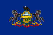
Pennsylvania flag detail
Home Earth Continents The Americas USA Country Profile US State Capitals Pennsylvania Map

US States Maps Index
World Maps Index

Map of Pennsylvania (PA)


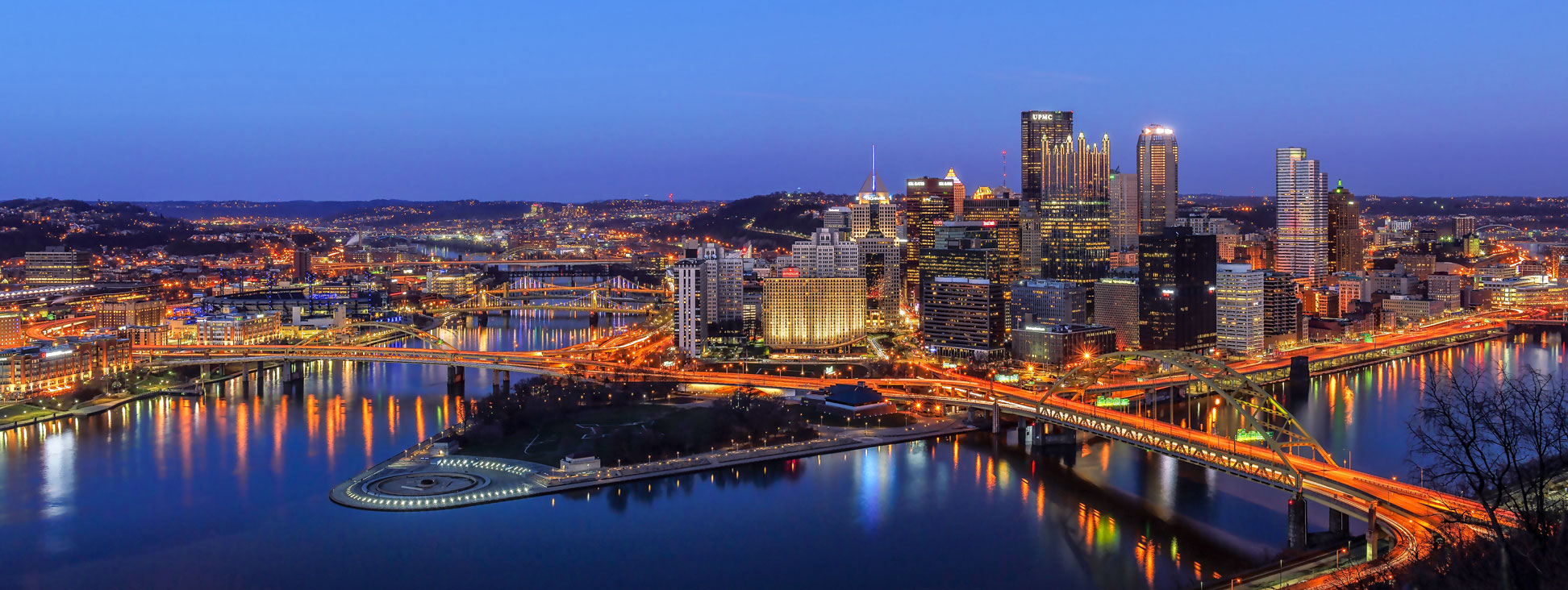
Downtown Pittsburgh at the confluence of the Allegheny and the Monongahela rivers at Point State Park.
View from Mt. Washington of downtown Pittsburgh at the confluence of the Allegheny (left) and the Monongahela rivers, which form the Ohio River at Point State Park.
Image: Vadim

Pennsylvania Flag
Pennsylvania State Flag


About Pennsylvania


Location map of Pennsylvania state USA
Where in the United States is Pennsylvania? Location map of Pennsylvania in the US.

 
Pennsylvania, officially the Commonwealth of Pennsylvania, is a state in the Mid-Atlantic region in the northeast of the United States; the landlocked state features a 70 km (43 mi) short shoreline at Lake Erie.

Pennsylvania borders New York in the north and northeast. The Delaware River forms sections of its eastern border with the US states of New York and New Jersey. In the south, the state is bounded by West Virginia, Maryland, and Delaware, and in the west by Ohio.


Early Days of Pennsylvania
In 1682, an English real estate entrepreneur named William Penn obtained sovereign control of the area with all rights and privileges (except the power to declare war). Pennsylvania was one of the 13 original colonies that abandoned the rule of the English Crown and later formed the United States. Pennsylvania ratified the U.S. Constitution on 12th December 1787 as the second state, after Delaware.
Pennsylvania attempted to be first to sign the constitution in the hope of securing the seat of the National Government in Pennsylvania. The Pennsylvania State House (now known as "Independence Hall") in Philadelphia was the seat of the American government during the revolutionary and early national years.


Pennsylvania State Map
Reference Map of Pennsylvania
General Map of Pennsylvania, United States.

The detailed map shows the US state of Pennsylvania with boundaries, the location of the state capital Harrisburg, major cities and populated places, rivers, and lakes, interstate highways, principal highways, railroads and major airports.

You are free to use the above map for educational and similar purposes; if you publish it online or in print, you need to credit Nations Online Project as the source.


More about Pennsylvania State


Some Geography

Area
Pennsylvania Topographic MapTopographic Regions Map of Pennsylvania. (click map to enlarge)
 
With an area of 119,279 km² (46,054 sq mi) [1], Pennsylvania is ranked 33 in the US list of the largest states, about one third the size of Germany.
Compared with other US states, New Jersey would fit into Pennsylvania more than five times. However, Texas is almost six times larger than the Quaker State (Pennsylvania's nickname).


The Appalachian Mountains, an eroded mountain chain in eastern North America, dominate Pennsylvania's landscape.


Major Geographic Regions of Pennsylvania


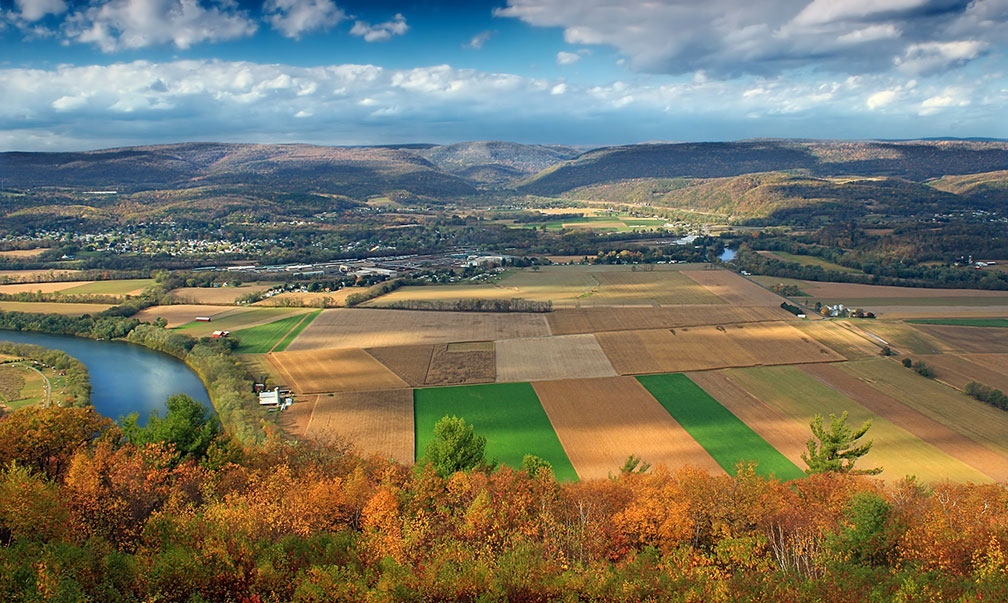
Susquehanna River Valley and the Allegheny Plateau
The West Branch of the Susquehanna River Valley and the Allegheny Plateau foothills. View from Aughanbaugh Road on Bald Eagle Mountain.
Image: Nicholas A. Tonelli

 
Located in the southeastern corner of the state, in the flat Atlantic Coastal Plain, sprawls the Philadelphia metropolitan area (Philadelphia-Camden-Wilmington MSA), with a population of more than 6 million people. The urban agglomeration is also sometimes referred to as the Delaware Valley.

To the northwest of Philadelphia metro extends the plateau region of the Pennsylvania Piedmont, an agricultural region of rolling hills in the state's portion of the Piedmont Plateau occupy the southeastern part of Pennsylvania.


Northeastern Pennsylvania

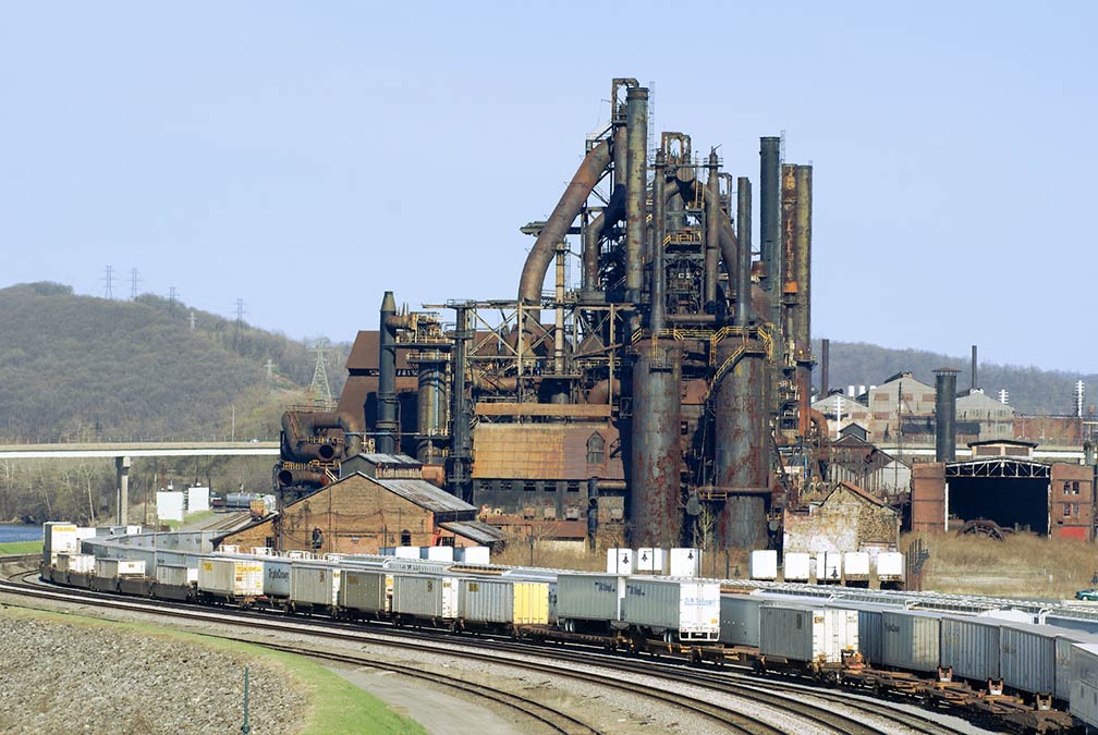
Bethlehem Steel blast furnace seen from the Fahy Bridge
They were making iron. View of Bethlehem Steel from the Fahy Bridge. Bethlehem Steel Corporation was an American steel and shipbuilding company and, for much of the 20th century, one of the world's largest steel producer.
Pennsylvania was home to two of the largest steel producers in the world; Pittsburgh-based U.S. Steel and Bethlehem-based Bethlehem Steel. The former blast furnace sites have either been destroyed, preserved, or in the case of Bethlehem, became a new multi-million dollar Sands Casino Resort in 2009 with a revenue of US$ 14.5 billion (FY 2014). [3]

Image: Jschnalzer

The landscape in the interior of the Commonwealth is dominated by the various land forms of the Appalachian Mountains. The northwestern part of Pennsylvania is characterized by the large dissected Allegheny Plateau and the Allegheny Mountains in the center of the state. Lake Erie Plain in the northwest is a narrow region along Lake Erie.


Highest point
Mount Davis in the Forbes State Forest, at 979 m (3,213 ft), is the highest point in the Commonwealth.


Rivers
Major rivers in Pennsylvania. The Allegheny River joins with the Monongahela River to form the Ohio River in Downtown Pittsburgh. The Delaware River defines the eastern border of the Commonwealth with New York State and New Jersey. The Susquehanna River, one of the oldest existing river systems in the world, is formed from two main branches: the "North Branch," which rises in upstate New York, and the "West Branch," which originates in the Allegheny Mountains in western Pennsylvania. The Schuylkill River and its tributaries drain major parts of the center-southern and easternmost Coal Regions in the state before joining the Delaware River.


Lakes
Major lakes in Pennsylvania are the Allegheny Reservoir (also known as Kinzua Lake), a human-made lake along the Allegheny River. The Raystown Lake, a reservoir at the Raystown Branch of the Juniata River, is the largest lake that is entirely within the state. Pennsylvania has a shoreline at Lake Erie, the fourth-largest lake (by surface area) of the five Great Lakes in North America.

 
World Heritage Site


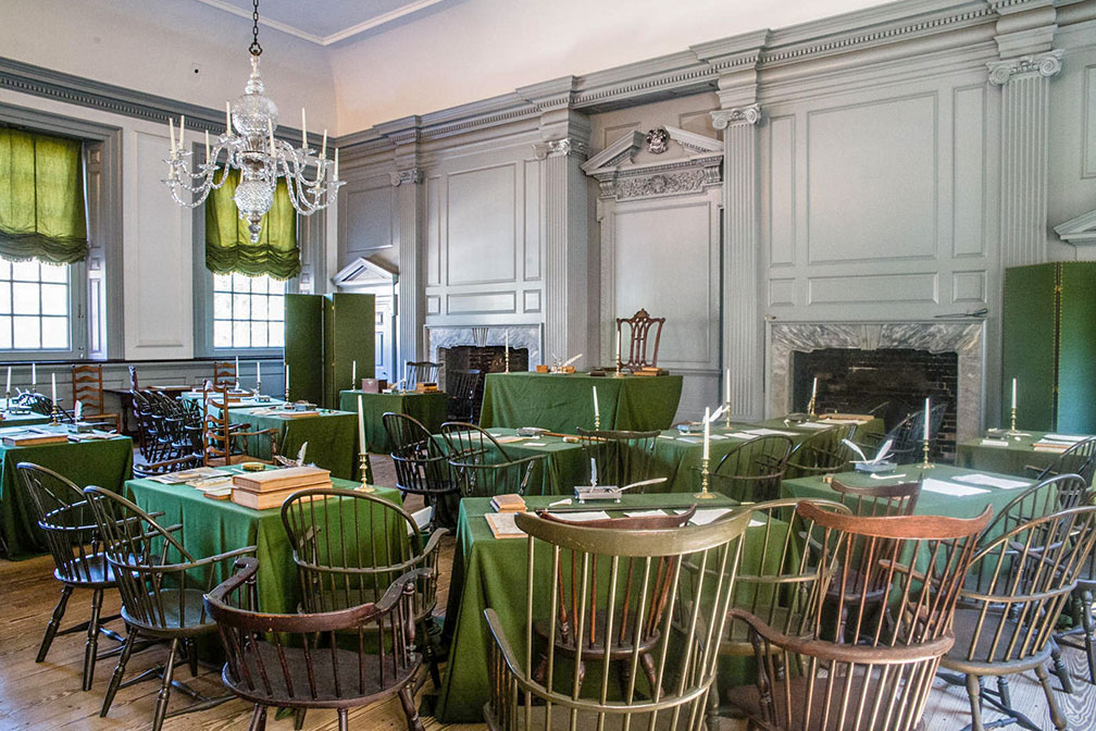
The Assembly Room in the Independence Hall in Philadelphia, Pennsylvania
The Assembly Room in the Independence Hall in Philadelphia. The hall is arranged as it was during the Constitutional Convention and featuring George Washington’s Rising Sun Armchair.
Image: Judith

 
Pennsylvania has one UNESCO World Heritage Site. The Independence Hall official website in Philadelphia is the building where both, the United States Declaration of Independence (1776) and the Constitution of the United States (1787), were argued and adopted.

The universal principles of freedom and democracy described in these documents are of fundamental importance to American history. They have also had a profound impact on law-makers around the world.

The Independence Hall was completed in 1753 as the colonial legislature for the Province of Pennsylvania. It was used in that field of activity until the state capital moved to Lancaster in 1799.


Population


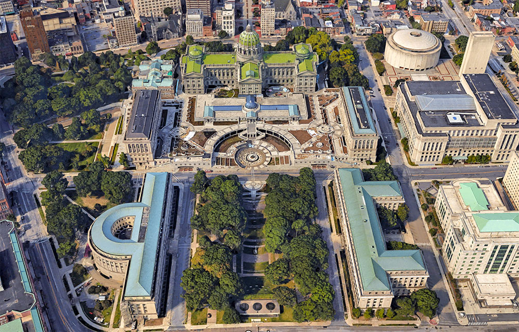
Pennsylvania State Capitol Complex in Harrisburg, Pennsylvania
Rendered image of Pennsylvania State Capitol Complex in downtown Harrisburg. The Capitol building houses the government of Pennsylvania.
Image: Google

 
The Commonwealth of Pennsylvania (aka The Keystone State (Pennsylvania's other nickname)) has a population of more than 12.9 million people (2021 est.) [2], making it the 6th most populous US state.

The capital city is Harrisburg; the largest city is Philadelphia, the largest urban area is Greater Philadelphia (Delaware Valley Metropolitan Area). Other major cities are Pittsburgh, Allentown, and Erie.

Philadelphia, Pittsburgh, Erie, Scranton-Wilkes-Barre, and Allentown-Bethlehem-Easton are the major urban manufacturing centers in the Commonwealth.


Race and Ethnic groups
The population of Pennsylvania is composed of White alone 76.1%, African American 12.0%, Hispanic or Latino 7.6%, Asian 3.7%, and Native American 0.4%. [3]


Cities and Towns in Pennsylvania

The map shows the location of following cities and towns in Pennsylvania:
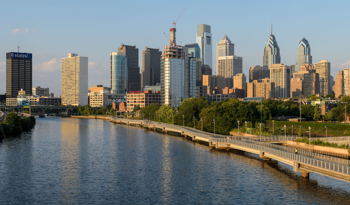
Philadelphia skyline from the South Street Bridge
Philadelphia skyline from the South Street Bridge. Philadelphia is the largest city in the Commonwealth of Pennsylvania and one of the oldest cities in the United States.
Image: King of Hearts

 
Largest cities in Pennsylvania with a population of more than 50,000:
Philadelphia (1,603,000), Pittsburgh (303,000), Allentown (125,800), Erie (94,800), Reading (95,100), Scranton (76,300), Bethlehem (75,800), Lancaster (58,000), Harrisburg (50,000)
Population figures in 2020


Largest Airports in Pennsylvania

The largest airport in the state is
Philadelphia International Airport
(IATA code: PHL),

other international airports are

Pittsburgh International Airport (IATA code: PIT),
Harrisburg International Airport (IATA code: MDT),
Allentown's Lehigh Valley International Airport (IATA code: ABE)


Other cities and towns in Pennsylvania

Aliquippa, Altoona, Beaver Falls, Bedford, Bellefonte, Berwick, Bethel Park, Bloomsburg, Bradford, Butler, Carbondale, Carlisle, Chambersburg, Chester, Clarion, Clearfield, Columbia, Connellsville, Corry, Coudersport, Doylestown, Du Bois, Easton, Edinboro, Emporium, Franklin, Gettysburg, Greensburg, Greenville, Grove City, Hanover, Hazleton, Honesdale, Huntingdon, Indiana, Jersey Shore, Johnstown, Kane, Kittanning, Lebanon, Levittown, Lewistown, Lock Haven, Mansfield, Meadville, Monroeville, Mt Lebanon, New Castle, New Kensington, Norristown, Oil City, Pittston, Pottstown, Pottsville, Punxsutawney, Sayre, Sharon, Shenandoah, Somerset, St Marys, State College, Stroudsburg, Sunbury, Titusville, Towanda, TyronendianaI, Uniontown, Warren, Washington, Waynesburg, Wellsboro, West Chester, Wilkes-Barre, Williamsport, and York.

Weather Conditions Philadelphia

PHILADELPHIA WEATHER


Advertisements:


Maps of the 50 U.S. States
Alabama | Alaska | Arizona | Arkansas | California | Colorado | Connecticut | Delaware | Florida | Georgia | Hawaii | Idaho | Illinois | Indiana | Iowa | Kansas | Kentucky | Louisiana | Maine | Maryland | Massachusetts | Michigan | Minnesota | Mississippi | Missouri | Montana | Nebraska | Nevada | New Hampshire | New Jersey | New Mexico | New York | North Carolina | North DakotaOhio | Oklahoma | Oregon | Pennsylvania | Rhode Island | South Carolina | South Dakota | Tennessee | Texas | Utah | Vermont | Virginia | Washington | West Virginia | Wisconsin | Wyoming

20 Most Populous U.S. Cities (in 2018):
1. New York City 2. Los Angeles 3. Chicago 4. Houston 5. Phoenix 6. Philadelphia 7. San Antonio 8. San Diego 9. Dallas 10. San Jose 11. Austin 12. Jacksonville 13. Fort Worth 14. Columbus 15. San Francisco 16. Charlotte 17. Indianapolis 18. Seattle, 19. Denver, 20. Washington D.C.

Other Major U.S. Cities:
Albany, Anchorage, Annapolis, Atlanta, Atlantic City, Augusta, Baltimore, Baton Rouge, Bismarck, Boise, Boston, Carson City, Charleston, WV, Cheyenne, Cincinnati, Cleveland, Columbia, Concord, Des Moines, Detroit, Dover, DE, El Paso, Frankfort, Harrisburg, Hartford, Helena, Honolulu, Jackson, Jefferson City, Juneau, Kansas City, Lansing, Las Vegas, Lincoln, Little Rock, Long Beach, Madison, Memphis, Miami, Milwaukee, Minneapolis, Montgomery, Montpelier, Nashville, New Orleans, Norfolk, Oklahoma City, Olympia, Orlando, Pierre, Pittsburgh, Portland, Providence, Richmond, VA, Raleigh, Sacramento, St. Louis, St. Paul, Salem (OR), Salt Lake City, Santa Fe, Springfield, Tallahassee, Tampa, Topeka, Trenton, Tucson