Nations Online
All Countries in the World
Nations Online All Countries in the World | |
Home  |
___ Searchable Map and Satellite View of the City of Fort Worth, Texas
|
About Fort Worth |
 The satellite view shows Fort Worth, a major city in the State of Texas in the The satellite view shows Fort Worth, a major city in the State of Texas in the 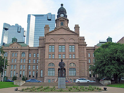 Fort Worth Tarrant County Courthouse with a statue of Charles David Tandy in the foreground. Image: Louis Reed In Dallas–Fort Worth–Arlington metropolitan area (commonly called the Metroplex), there live 7.7 million people (2015 est.). The city is home to the Kimbell Art Museum, one of the finest museums in the Southwest. Among Fort Worth's top employers are Lockheed Martin Aeronautics, American Airlines Group, and Bell Helicopter. BNSF Railway, the second-largest freight railroad network in North America, and RadioShack have their headquarters in the city. The Map shows a city map of Fort Worth with expressways, main roads and streets. Zoom out to find the location of Fort Worth Alliance Airport (IATA code: AFW) the city-owned cargo airport about 18 mi (29 km) north of the central business district of the city. Dallas/Fort Worth International Airport (IATA code: DFW), 23 mi (37 km) by road located in north-east, between the cities of Dallas and Fort Worth. Just zoom in to see Fort Worth Convention Center southeast of the Central Business District. To find a location use the form below. |
|
| To find a location type: street or place, city, optional: state, country. |
Local Time Fort Worth:
Thursday-April-18 22:55
Standard time zone: Central Standard Time (CST); UTC/GMT -6 hours
Central Daylight Time (CDT) in use from the second Sunday in March, ends on the first Sunday in November; time zone offset: UTC/GMT -5 hours |
One World - Nations Online .:. let's care for this planet Promote that every nation assumes responsibility for our world. Nations Online Project is made to improve cross-cultural understanding and global awareness. More signal - less NOISE |
| Site Map
| Information Sources | Disclaimer | Copyright © 1998-2023 :: nationsonline.org |

