Nations Online
All Countries in the World
Nations Online All Countries in the World | |
Home  |
___ Searchable Map and Satellite View of Philadelphia (PA) (45-degree view available) |
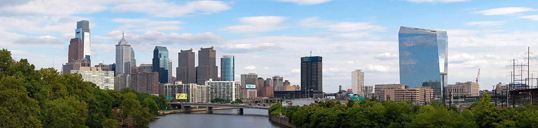 Skyline of downtown Philadelphia with Center City, the Comcast Center (far left) on the left bank of Schuylkill River, and the office high-rise of Cira Centre in the University City section of Philadelphia on the right bank. View from Spring Garden Street Bridge over the Schuylkill River. Photo: Massimo Catarinella |
About Philadelphia |
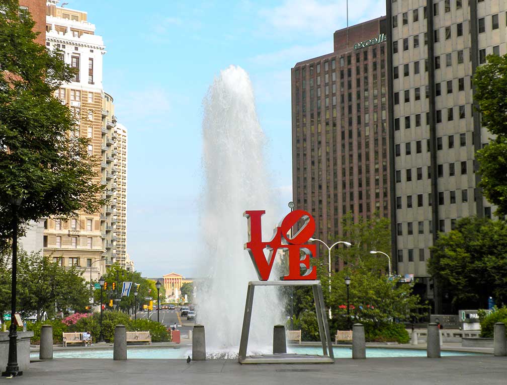
 Satellite view showing Philadelphia, largest city in Pennsylvania and the fifth most populous city in the Satellite view showing Philadelphia, largest city in Pennsylvania and the fifth most populous city in the 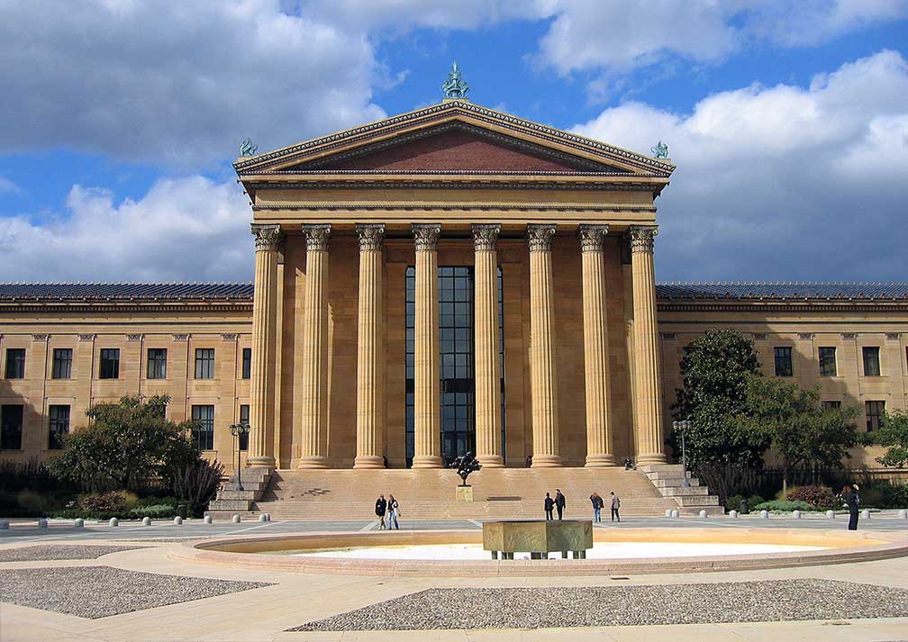 East entrance of the Philadelphia Museum of Art. The Museum houses more than 227,000 objects showing the creative achievements of the Western world since the first century CE and those of Asia since the third millennium BCE. The city's success waned in the in the late 1960s and its economic base declined significantly. Philadelphia struggled for the next decades with job and population loss. The number of jobs in the city has dropped by approximately 250,000 over the last 25 years (in 1996). Revitalization of the city began in the late 1990s, with reurbanization and gentrification which countered the problem of inner city decline and population loss. Today Philadelphia is Pennsylvania's largest city with a population of more than 1.5 million inhabitants (in 2015), 6 million people live in the Philadelphia-Camden-Wilmington metropolitan area. The city is home to the University of Pennsylvania. The City of Brotherly Love (from Greece: "philos", meaning "love" and "delphos", meaning "brother"), it is the origin of the city's name of Philadelphia. The name deteriorated long ago to Philly, it rhymes with ..., you name it. Philadelphia points of interest: Historical Places: Independence Hall, the former Pennsylvania State House, it was the place where the United States Declaration of Independence and the United States Constitution were adopted. Liberty Bell, the iconic symbol of American independence, located in the Liberty Bell Center in the Independence National Historical Park, a historic complex associated with the American Revolution and the nation's founding history. Eastern State Penitentiary, historic former prison in Philadelphia, ESP was in operation from 1829 until 1971, it is now open to the public. Carpenters' Hall, historic craft guild meeting hall, the First Continental Congress met at Carpenters' Hall in October 1774. Places: LOVE Park (plaza with Robert Indiana's famous Love sculpture) Art Museums: Philadelphia Museum of Art, is among the largest art museums in the United States. Within the museum complex in Fairmount Park are the Rodin Museum, with the largest collection of works by Auguste Rodin outside Paris on display, and the Art Deco Ruth and Raymond G. Perelman Building on Pennsylvania Ave with its six galleries. To the south east of Rodin Museum is Barnes Foundation, collection of world-class European modern art with works, among many others, by Renoir, Cézanne, Matisse, and Picasso. Pennsylvania Academy of the Fine Arts, PAFA is the first and oldest art museum and art school in the US, the Victorian style musem exhibits a renowned collection of 19th- and 20th-century American paintings, sculptures, and works on paper.  Pennsylvania Academy of the Fine Arts, PAFA at 118-128 N Broad St and Cherry St, Philadelphia. Image: Terry Robinson Performing Arts: Kimmel Center, performing arts venue, includes Verizon Hall, home of the Philadelphia Orchestra, the Perelman Theater, the Pennsylvania Ballet, and the Academy of Music. Annenberg Center Plaza, venue for live music, dance and theater, jazz & world music. The Mann Center, seasonal outdoor theater in Fairmount Park. Events: The Democratic National Convention will be held on 25-28 July 2016 at the Wells Fargo Center, and the political world will converge on Philadelphia. The Oval, seasonal pop-up of a pedestrian-friendly outdoor public space on Benjamin Franklin Parkway (July 15 – August 21, 2016). Shopping: Reading Terminal Market, famous indoor farmer's market. Philadelphia hosts also the nation's oldest Thanksgiving Day Parade. 4 Kids: Please Touch Museum (children's museum in Fairmount Park) Parks: Franklin Square (one of the original open-space parks planned by William Penn). Fairmount Park, urban park along both banks of the Schuylkill river, within the park there is Shofuso, a 17th century-style Japanese house and garden, Philadelphia Zoo (premier zoo and the first zoo in the United States), Wissahickon Valley Park, a park with a gorge and many trails alongside the Wissahickon Creek, now part of Fairmount Park system. Spruce Street Harbor Park (local summer gathering at Delaware River, with ping pong tables, shuffleboard station and a jumbo-sized chess board) Just zoom in (+) to see the Independence Hall, the Declaration of Independence (1776) and the Constitution of the United States (1787) were both signed in this building. Today it is a UNESCO World Heritage Site The page shows a city map of Philadelphia with expressways, main roads and streets, zoom out to find the location of Philadelphia International Airport (IATA code: PHL) located 19 km (12 mi) by road (via I-95 S) southwest from downtown Philadelphia. |
|
| To find a location type: street or place, city, optional: state, country. |
Local Time Philadelphia:
Wednsday-April-24 2024 01:38
Standard time zone Eastern (EST): UTC/GMT -5 hoursDaylight Saving Time (EDT) in use from the second Sunday in March, ends on the first Sunday in November; time zone offset: UTC/GMT -4 hours |
One World - Nations Online .:. let's care for this planet Promote that every nation assumes responsibility for our world. Nations Online Project is made to improve cross-cultural understanding and global awareness. More signal - less NOISE |
| Site Map
| Information Sources | Disclaimer | Copyright © 1998-2023 :: nationsonline.org |