Advertising

Rhode Island Flag detail
Home Earth Continents The Americas USA Country Profile US State Capitals Rhode Island Map

US States Maps Index
World Maps Index

Map of Rhode Island (RI)


Claiborne Pell Bridge, Narragansett Bay
The Claiborne Pell Bridge (Newport Harbor Light to the left), the suspension bridge traverses the East Passage of the Narragansett Bay connecting Newport on Aquidneck Island (Rhode Island) with Conanicut Island. The bridge looks good, but according to the U.S. Department of Transportation, Rhode Island's bridges are the worst in the nation. [1]
Image: © Ad Meskens

 
Rhode Island Flag
Rhode Island State Flag


About Rhode Island


Location map of Rhode Island state USA
Where in the United States is Rhode Island? Location map of Rhode Island in the US.

 
Rhode Island, officially the State of Rhode Island and Providence Plantations, is not an island. It is the smallest of the 50 US states by area and situated on the East Coast of the United States in the New England Region. Compared, it is just about twice the size of the city of Phoenix in Arizona.

Rhode Island has land borders with only two other states, on the north and east with Massachusetts and in the west with Connecticut. In the south, RI is bounded by the straits of Block Island Sound and Rhode Island Sound. It shares a short maritime border with New York State between Block Island, RI and Long Island, NY. Narragansett Bay, an inlet of the Atlantic Ocean, extends deep into the southeastern portion of Rhode Island.


Rhode Island State Map
Reference Map of Rhode Island
General Map of Rhode Island, United States.

The detailed map shows the US state of Rhode Island with boundaries, the location of the state capital Providence, major cities and populated places, rivers and lakes, interstate highways, principal highways, and railroads.

You are free to use this map for educational purposes (fair use); please refer to the Nations Online Project.

 
More about Rhode Island State


Short History
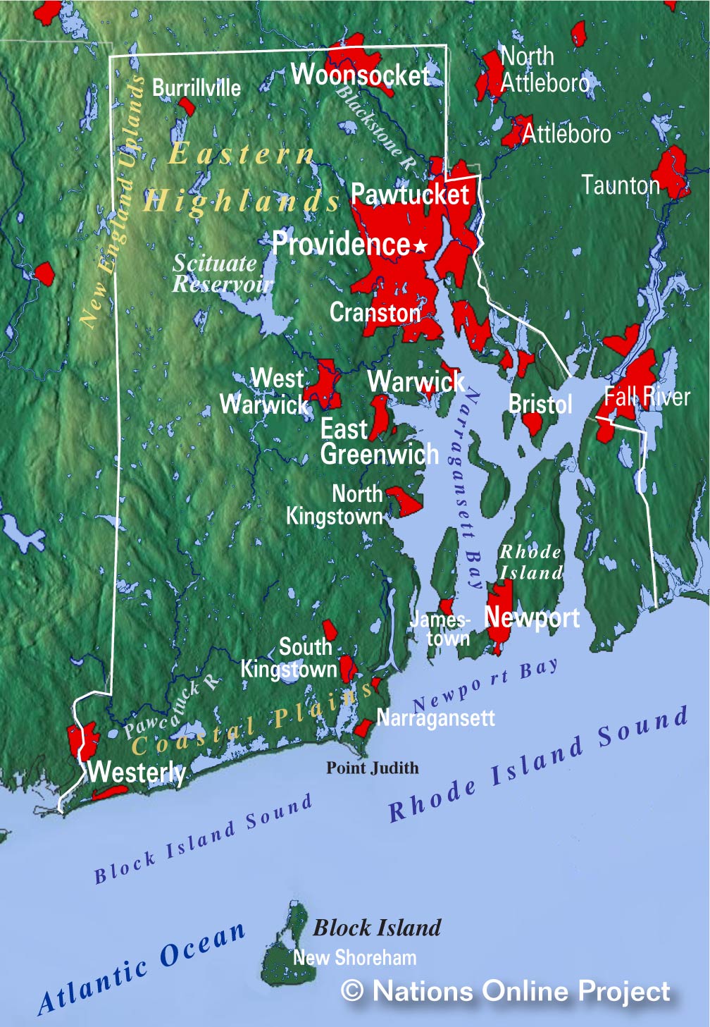
Rhode Island Topographic Regions Map
Topographic Regions Map of Rhode Island. (click map to enlarge)

 
The Colony of Rhode Island and Providence Plantations was created in the 17th century. English colonists first settled on present-day Aquidneck Island (Rhode Island) in the 1630s.

Nearly one and a half century later, in 1776, the colony declared independence from the British Crown as the first of the thirteen original American colonies. However, it was the last to sign the Constitution, so it became the 13th constituent US state.


Area

Rhode Island covers a total area of 3,999 km² (1,544 sq mi), [2] a third of which is water (1,324 km² or 511 square miles).
This feature might be the reason for its official nickname "The Ocean State," the other one is 'Little Rhody.' It is the smallest US state by area. Compared with other US states, Rhode Island would fit into New Jersey seven times and into Texas 222 times.


Rhode Island Geography
Rhode Island consists of five counties, four major islands, and one estuary (Narragansett Bay).

The five counties are (ordered by their population (in 2019)) Providence County (637,000), Kent County (164,300), Washington County (125,500), Newport County (82,000), and Bristol County (48,500).

The geography of Rhode Island consists of two principal regions: the southern and eastern Coastal Lowlands and the Eastern New England Upland (ENEU), also known as the Eastern Highlands, in the northwest.
More than half of the state is covered with forests.


Islands


Mohegan Bluffs, Block Island, Rhode Island Mohegan Bluffs, clay cliffs on the southern shore of Block Island.
Image: Rob Weir
 
The Ocean State's four main islands are Aquidneck Island, officially Rhode Island, which is the largest island of Narragansett Bay and belongs to Newport County. About 60,000 people live on Aquidneck. The largest town on the island is Newport, the rest of the population is divided between the communities of Middletown and Portsmouth.

Conanicut is the second-largest island in Narragansett Bay; the Newport Bridge connects Conanicut with Aquidneck Island and Newport.


The third-largest island in Narragansett Bay is Prudence, which features some summer colonies. Block Island lies about 16 km south of the coast of the mainland.


Rivers
Major rivers are the Pawcatuck River, which flows into the Little Narragansett Bay, its source is Worden Pond. The Wood River is a major tributary of the Pawcatuck River. The North Branch Pawtuxet River feeds the Scituate Reservoir. The Blackstone River was once the most polluted in the country. The Sakonnet River is an estuary or tidal strait which runs north to south, east of Aquidneck Island.

 
Lakes


Little Compton, view from Sakonnet Harbor,  Rhode Island
Little Compton, view from Sakonnet Harbor.
Image: Zhengan

 
Rhode Island is home to more than 200 inland ponds and lakes of varying sizes, most of them human-made. The largest inland body of water is the Scituate Reservoir fed by precipitation and several streams; it is the primary drinking water supply for the city of Providence and surrounding towns.

Worden Pond is a medium-sized natural freshwater lake in Washington County; it is the source for the Pawcatuck River. Ninigret Pond is the largest of the nine lagoons, or "salt ponds," in southern Rhode Island, other major salt ponds are Potter Pond, Point Judith Pond, Trustom Pond, Green Hill Pond, Quonochontaug Pond, and the Winnpaug Pond.


Highest point
Rhode Island's landscape is quite flat; it has no real mountains. The state's highest natural point is Jerimoth Hill at 247 m (812 feet) above sea level within the New England Upland in Western Rhode Island.

 
Population

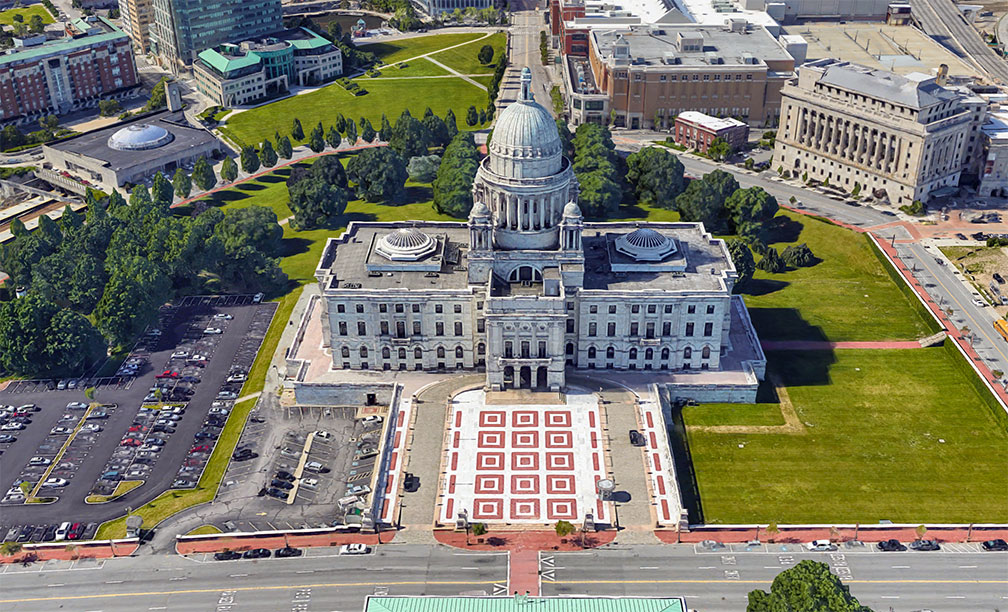
Rhode Island State House in Providence, RI
Rendered image of Rhode Island State House. The Capitol of Rhode Island is a neoclassical style building that houses the Rhode Island General Assembly and the offices of the governor.
Image: Google
 
Rhode Island is heavily urbanized in its eastern half, with the exception of a portion of Newport County between the Sakonnet River and the Massachusetts state border. It is the second-most densely populated state in the US (after New Jersey), with a population of 1,059,300 people (43rd in the US; 2019 est.). [3]

The largest city and state capital is Providence (pop. 180,000, in 2019), the largest urban area is Providence-Warwick, RI-MA Metro with a population of 1.6 million people, approximately 600,000 inhabitants more than Rhode Island itself, because of the metro's expansion into southern Massachusetts.

Other major cities are Warwick (pop. 81,700), Cranston (pop. 81,000), Pawtucket (pop. 71,600), East Providence, Woonsocket, and the port city of Newport.

Race and Ethnic groups
The ethnic groups of Rhode Island consist of Caucasian 72.0%, Hispanic or Latino 15.9%, African American 8.4%, Asian 3.6%, and Native American 1.1%. [4]

The busiest airport in the state is Providence/Warwick Theodore Francis Green State Airport (IATA code: PVD).
 
Cities and Towns in Rhode Island

Skyline of Downtown Providence, Rhode Island
Skyline of Downtown Providence, Rhode Island's capital and largest city.
Image: Kenneth C. Zirkel 
The map shows the location of following cities and towns in Rhode Island:

Largest cities in Rhode Island with a population of more than 40,000:
Providence (179,200), Warwick (81,700), Cranston (81,000), Pawtucket (71,600), East Providence (47,000), Woonsocket (41,200)
Population figures in 2018

Other cities and towns in Rhode Island:

Bristol, East Greenwich, Hope Valley, Kingston, New Shoreham, Newport, North Providence, Pascoag, Portsmouth, Tiverton, Wakefield, Warren, West Warwick, and Westerly.


Weather Conditions Providence:

PROVIDENCE WEATHER


Advertisements:


Maps of the 50 U.S. States
Alabama | Alaska | Arizona | Arkansas | California | Colorado | Connecticut | Delaware | Florida | Georgia | Hawaii | Idaho | Illinois | Indiana | Iowa | Kansas | Kentucky | Louisiana | Maine | Maryland | Massachusetts | Michigan | Minnesota | Mississippi | Missouri | Montana | Nebraska | Nevada | New Hampshire | New Jersey | New Mexico | New York | North Carolina | North DakotaOhio | Oklahoma | Oregon | Pennsylvania | Rhode Island | South Carolina | South Dakota | Tennessee | Texas | Utah | Vermont | Virginia | Washington | West Virginia | Wisconsin | Wyoming

20 Most Populous U.S. Cities (in 2018):
1. New York City 2. Los Angeles 3. Chicago 4. Houston 5. Phoenix 6. Philadelphia 7. San Antonio 8. San Diego 9. Dallas 10. San Jose 11. Austin 12. Jacksonville 13. Fort Worth 14. Columbus 15. San Francisco 16. Charlotte 17. Indianapolis 18. Seattle, 19. Denver, 20. Washington D.C.

Other Major U.S. Cities:
Albany, Anchorage, Annapolis, Atlanta, Atlantic City, Augusta, Baltimore, Baton Rouge, Bismarck, Boise, Boston, Carson City, Charleston, WV, Cheyenne, Cincinnati, Cleveland, Columbia, Concord, Des Moines, Detroit, Dover, DE, El Paso, Frankfort, Harrisburg, Hartford, Helena, Honolulu, Jackson, Jefferson City, Juneau, Kansas City, Lansing, Las Vegas, Lincoln, Little Rock, Long Beach, Madison, Memphis, Miami, Milwaukee, Minneapolis, Montgomery, Montpelier, Nashville, New Orleans, Norfolk, Oklahoma City, Olympia, Orlando, Pierre, Pittsburgh, Portland, Providence, Richmond, VA, Raleigh, Sacramento, St. Louis, St. Paul, Salem (OR), Salt Lake City, Santa Fe, Springfield, Tallahassee, Tampa, Topeka, Trenton, Tucson