Nations Online
All Countries in the World
Nations Online All Countries in the World | |
Home  |
___ Searchable Map and Satellite View of Detroit, MI (with 45-degree image coverage) |
About Detroit |
 The satellite view shows Detroit, largest city in Michigan and the seat of Wayne County in the The satellite view shows Detroit, largest city in Michigan and the seat of Wayne County in the Detroit was founded in 1701, today (2015) the city has a population of 677,000 inhabitants, 4.3 million people live in the metropolitan area (Metro Detroit). 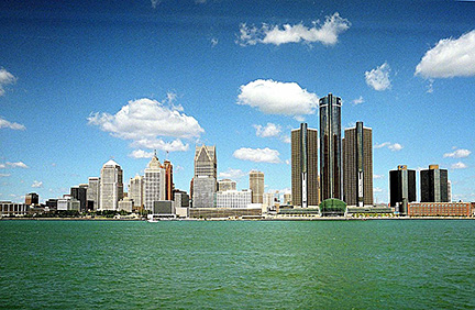 Skyline of the City of Detroit, Michigan at the Detroit International Riverfront at Detroit River. Tallest buildings are the Renaissance Center (RenCen) owned by General Motors as its world headquarters. The central tower is the Detroit Marriott at the Renaissance Center. Photo: Mike Russell Detroit's Motown Sound and world famous artists such as John Lee Hooker, Stevie Wonder, The Temptations, Diana Ross & The Supremes, The Jackson 5, Aretha Franklin and many other musicians shaped the reputation of Detroit as a music city. Among Detroit's most important cultural institution are The Henry Ford, the nation's "largest indoor-outdoor history museum", the Detroit Institute of Arts and the Detroit Zoo. Located in the Cultural Center Historic District around Wayne State University are the Detroit Historical Museum, and the Charles H. Wright Museum of African American History. The Map shows a city map of Detroit with expressways, main roads, and streets, zoom out to find the location of Detroit Metropolitan Wayne County Airport (IATA code: DTW) located 21 mi (34 km) by road in southwest, and Coleman A. Young Municipal Airport (IATA code: DET) about 8 mi (13 km) by road northeast of the central business district. To find a location use the form below. To view just the map, click on the "Map" button. |
|
| To find a location type: street or place, city, optional: state, country. |
Local Time Detroit:
Wednsday-April-17 2024 18:32
Standard time zone Eastern (EST): UTC/GMT -5 hoursDaylight Saving Time (EDT) in use from the second Sunday in March, ends on the first Sunday in November; time zone offset: UTC/GMT -4 hours |
One World - Nations Online .:. let's care for this planet Promote that every nation assumes responsibility for our world. Nations Online Project is made to improve cross-cultural understanding and global awareness. More signal - less NOISE |
| Site Map
| Information Sources | Disclaimer | Copyright © 1998-2023 :: nationsonline.org |

