Nations Online
All Countries in the World
|
One Planet Nations Online All Countries in the World | |
Home  |
___ Satellite View and Map of Greece and the Greek Islands |
 Panoramic view of the Santorini caldera, taken from the town of Oia. Santorini today is what remained after a tremendous volcanic eruption that destroyed the earliest settlements on the formerly single island, the eruption created the caldera. Image: Leonard G. |
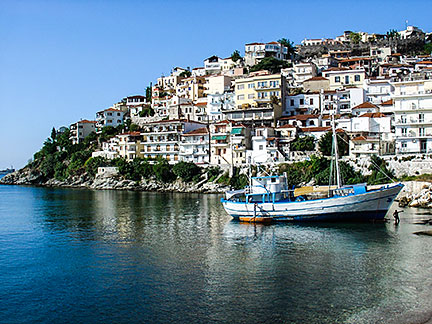
About Greece Satellite view is showing Greece, a Mediterranean country in southeastern Europe composed of 2 main peninsulas and some thousands of islands in the Aegean (west) and Ionian seas (east of mainland Greece). Satellite view is showing Greece, a Mediterranean country in southeastern Europe composed of 2 main peninsulas and some thousands of islands in the Aegean (west) and Ionian seas (east of mainland Greece).With an area of 132 000 km² Greece is slightly larger than half the size of the United Kingdom, or slightly smaller than the U.S. state of Alabama. Greece has a population is about 10.8 million people. Spoken languages are Greek (official) and Turkish (predominantly spoken by a minority of Turks in Western Thrace). The Greek Islands: About 6,000 islands and islets in the Mediterranean Sea belong to Greece, 227 of them are inhabited. The markers on the map point to the largest Greek islands, a click on a marker reveals a short description of each island.  Kavala is the second largest city in northern Greece and the principal seaport of eastern Macedonia, a historical region of Greece. Image: P. Vasiliadis Border countries are: Albania, Bulgaria, Turkey, and the Republic of Macedonia, Greece shares maritime borders with Cyprus, Egypt, Italy, and Libya. Largest city and the national capital is Spoken language is Greek (official). The Map shows Greece with prefecture capitals, cities, islands, expressways, main roads and streets and the location of Athens International Airport, Macedonia International Airport (IATA code: SKG) in Thessaloniki, and "Eleftherios Venizelos" (IATA code: ATH), and Heraklion International Airport, "Nikos Kazantzakis" on the island of Crete (IATA code: HER). To find a location use the form below. To view the map, click on the "Map" button. |
|
| To find a location type: street or place, city, optional: state, country. |
Local Time Greece:
Friday-April-26 20:13
Standard Time Zone (EET): UTC/GMT +2 hoursDaylight Saving Time in use from end of March until end of October: time zone offset: UTC/GMT +3 hours |
|
φ Latitude, λ Longitude (of Map center; move the map to see coordinates): , |
||||||
| Google Earth: Searchable map and satellite view of the Hellenic Republic (Greece). |
Bookmark/share this page |
|||||
| More about Greece: Landmarks: Cities: Country: Cyprus: Continent: Political Map of the Mediterranean Region. Political Map of the Balkans. |
Current Weather Conditions Athens |
Explore more:
Related Consumer Information:
|
||||
One World - Nations Online .:. let's care for this planet Promote that every nation assumes responsibility for our world. Nations Online Project is made to improve cross-cultural understanding and global awareness. More signal - less NOISE |
| Site Map
| Information Sources | Disclaimer | Copyright © 1998-2023 :: nationsonline.org |