Nations Online
All Countries in the World
Nations Online All Countries in the World | |
Home  |
___ Satellite View and Map of Slovenia |
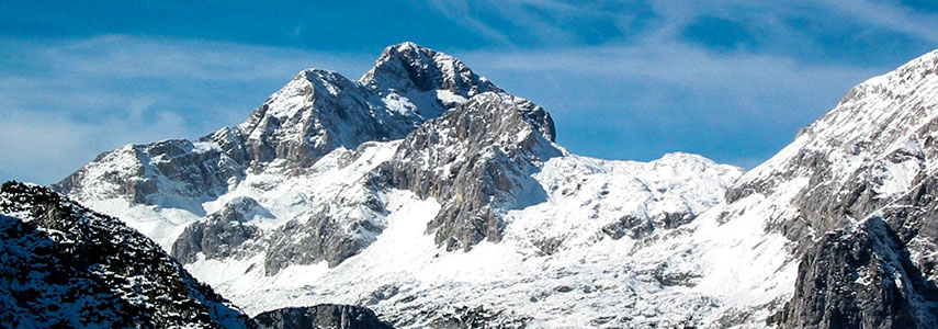 Triglav mountain is part of the Julian Alps and Slovenia's highest point at 2,864 m (9,396 ft). The mountain rises within the Triglav National Park, the country's only national park. The mountain is symbolized in the Slovenian flag and the nation's Coat of Arms. Image: Andrejj |
About Slovenia Satellite view is showing Slovenia a relative small, mostly mountainous country in southeastern Europe, bordering the Adriatic Sea with a relative short coastline (46 km) between Italy and Croatia. Satellite view is showing Slovenia a relative small, mostly mountainous country in southeastern Europe, bordering the Adriatic Sea with a relative short coastline (46 km) between Italy and Croatia.Countries with international borders to Slovenia are Austria (to the north), Croatia (in south), Italy (in west), and Hungary (in east). With an area of 20,273 km² Slovenia is about half the size of Switzerland or slightly smaller than the U.S. state of New Jersey. 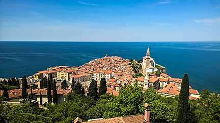 The Adriatic town of Piran at the Gulf of Piran (Gulf of Trieste), one of the three major towns of Slovene Istria, the northern portion of the Istria peninsula. Image: moonbee Slovenia has a population of just over 2 million people. Largest city and capital is Ljubljana with about 278,000 residents (in 2015). Spoken languages are Slovenian (official; 91%) and Serbo-Croatian (4.5%). The major religion is Christianity (about 60%). The map shows Slovenia with cities, towns, expressways, main roads and streets. To find a location use the form below. To view just the map, click on the "Map" button. |
|
| To find a location type: street or place, city, optional: state, country. | Local Time Slovenia:
Tuesday-July-21 01:21
Standard Time Zone (CET): UTC/GMT +1 hourCEST (Daylight Saving Time) in use from end of March until end of October: time zone offset: UTC/GMT +2 hours |
One World - Nations Online .:. let's care for this planet Promote that every nation assumes responsibility for our world. Nations Online Project is made to improve cross-cultural understanding and global awareness. More signal - less NOISE |
| Site Map
| Information Sources | Disclaimer | Copyright © 1998-2024:: nationsonline.org |

