Nations Online
All Countries in the World
Nations Online All Countries in the World | |
Home  |
___ Satellite View of Benghazi ( بنغازي ), Libya |
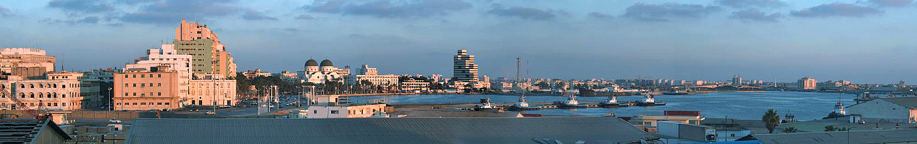 Panorama of Benghazi as viewed from the Port Administration building. Image by: Dennixo |
About BenghaziSatellite view is showing Benghazi, the second largest city and a major seaport inIt is located in northeastern Libya at the coast of the Gulf of Sidra (Mediterranean Sea). The city was founded by Greeks about five centuries BCE, its ancient name was Euesperides. Present-day Benghazi is the most important city in Libya after Tripoli, it is the main city of the Cyrenaica region in Eastern Libya, and one of Libya's major economic, industrial, and financial centers. Benghazi is seat of institutions and organizations normally associated with a national capital city, one of the three branches of the Central Bank of Libya is located in Benghazi, as well as the Arabian Gulf Oil Company, a subsidiary of the state-owned National Oil Corporation (NOC) has its headquarter in the city. The overwhelming majority of Libyans in Benghazi are of Arab descent, more than half a million people live in the city, while people in the region of Tripoli (Tripolitana) has a historical Berber background. All this has created an ongoing atmosphere of rivalry and sensitivities between Benghazi and Tripoli. Benghazi is also an educational center, it is home to the country's largest university (Garyounis University) and Libya's largest library. The city was in February 2011 the point of origin of the Libyan uprising against Gaddafi's regime. Here it was where the National Transitional Council of Libya was founded. The city was also the site of the turning point of the 2011 Libyan civil war when the Gaddafi's Army was forced back by local resistance and intervention from the NATO Air Force. In the night from 11 to 12 September 2012 the US consulate in Benghazi was attacked by a mob of unidentified armed men, US ambassador to Libya J. Christopher Stevens, and three others Americans died in the attack. Suspected of the attacks is Ansar al-Sharia, a Salafist Islamist militia group. The map shows a city map of Benghazi with expressways, main roads and streets, zoom out to find Benina International Airport; (IATA code: BEN), located in Benina (Baninah) 20 km (12 mi) east of Benghazi city. To find a location use the form below. To view just the map, click on the "Map" button. |
|
| To find a location type: street or place, city, optional: state, country. |
Local Time Benghazi:
Sunday-June-21 00:53
UTC/GMT +2 hours |
One World - Nations Online .:. let's care for this planet Promote that every nation assumes responsibility for our world. Nations Online Project is made to improve cross-cultural understanding and global awareness. More signal - less NOISE |
| Site Map
| Information Sources | Disclaimer | Copyright © 1998-2024:: nationsonline.org |

