Nations Online
All Countries in the World
Nations Online All Countries in the World | |
Home  |
___ Satellite View and Map of Brazil (Brasil) |
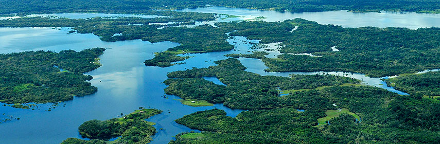 Aerial view of the Amazon Rainforest, near Manaus in the center of Amazonas state of Brazil. Image: Neil Palmer (CIAT) |
About BrazilBrazil is situated in the east-central part of the South American continent, with a coastline at the Atlantic Ocean.With its vast area, the country is the fifth largest nation in the world and the largest country in South America and in the Southern Hemisphere, and yes, it is larger than Australia, and larger than the contiguous United States. Brazil is bordered by French Guiana, Suriname, Guyana, and Venezuela in north, by Colombia in north-west, by Peru, Bolivia, and Paraguay in west, by Argentina in south-west, and by Uruguay in south. 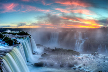 Iguazu Falls (Iguaçu) is part of the Iguazu National Park at the border between Brazil and Argentina. - Image: SF Brit Brazil has a population of 203 million people (2014), the national capital is Brasília, largest city is Sao Paulo, Brazil's economic capital and most famous city is Rio de Janeiro. Other major cities are Salvador (da Bahia), Fortaleza, Belo Horizonte, Manaus, Curitiba, Recife, Porto Alegre, Belém, Goiânia, São Luís, Maceió. Spoken language is Brazilian Portuguese. The map shows Brazil with the boundaries of its 26 states (estados), the state capitals, major cities, expressways, main roads, and streets. To find a location use the form below. |
|
| To find a location type: street or place, city, optional: state, country. |
Local Time Brasilia:
Friday-July-17 10:05
Brazil Standard Time: UTC/GMT -3 hoursDaylight Saving Time starts on the 3rd Sunday of October and ends on the 3rd Sunday of February shifts to UTC/GMT -2 hours. |
|
φ Latitude, λ Longitude (of Map center; move the map to see coordinates): , |
||||||||||
| Google Maps: Searchable Map and Satellite view of Brazil. Some Points of interest: Rio de Janeiro with Copacabana, Arpoador, Leblon, and Ipanema, carnival, Sugarloaf Mountain and Christ the Redeemer, the Teatro Municipal. São Paulo with São Paulo Museum of Art, Pinacoteca do Estado de São Paulo and Museu Paulista, São Paulo Cathedral, Sala São Paulo (Júlio Prestes Cultural Center) Salvador with its Historic Centre. Penha with Beto Carrero World, the biggest theme park in Latin America. Amazon rainforest, Iguazu Falls, Fernando de Noronha islands, Chapada Diamantina National Park, Lençóis Maranhenses National Park, Chapada dos Veadeiros National Park. |
Bookmark/share this page |
|||||||||
| More about Brazil: Cities - information and a searchable map/satellite view of: Brazil's provincial capitals: Country: Continent: |
Current Weather Conditions:
|
Related Consumer Information:
|
||||||||
| Searchable Maps of other Countries in South America: Argentina, Brazil, Bolivia, Chile, Colombia, Ecuador, French Guiana Guyana, Paraguay, Peru, Suriname, Uruguay, Venezuela Maps of other Countries in South America: Argentina Map, Brazil Map, Bolivia Map, Chile Map, Colombia Map, Ecuador Map, French Guiana Map, Guyana Map, Paraguay Map, Peru Map, Suriname Map, Uruguay Map, Venezuela Map Countries and Territories of The Americas |
||
Map Help [ show ] |
One World - Nations Online .:. let's care for this planet Promote that every nation assumes responsibility for our world. Nations Online Project is made to improve cross-cultural understanding and global awareness. More signal - less NOISE |
| Site Map
| Information Sources | Disclaimer | Copyright © 1998-2024:: nationsonline.org |


