Nations Online
All Countries in the World
Nations Online All Countries in the World | |
Home  |
___ Satellite View and Map of the City of Porto Velho - Rondônia |
About the City of Porto Velho
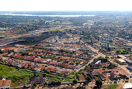 Aerial photo of Porto Velho. Image: Agência Brasil The city was founded in the beginning of the 20th century with the construction of the now abandoned Madeira-Mamoré Railroad. The railroad linked Bolivian rubber production with the navigable Amazon river. Porto Velho became capital of the newly formed Federal Territory of Guaporé in 1943, which was renamed Rondônia in 1956. Today the city has a population of almost half a million people (2013). Its economy is mostly based on service (83%). |
|
| To find a location type: street or place, city, optional: state, country. |
Local Time Porto Velho:
Saturday-August-1 00:28
Amazon Time (AMT): UTC/GMT -4 hours |
|
φ Latitude, λ Longitude (of Map center; move the map to see coordinates): , |
||||||
| Google Earth: Searchable map/satellite view of the City of Porto Velho, Rondônia, Brazil. City Coordinates: 8°45′43″S 63°54′14″W |
Bookmark/share this page |
|||||
| More about Brazil: Cities - background notes and a searchable map/satellite view of other Brazilian cities: Country: Continent: |
Weather Conditions Porto Velho
External Links: Porto Velho (official website) Wikipedia: Porto Velho Wikipedia entry: Porto Velho |
Explore more:
Related Consumer Information:
|
||||
Other Cities in South America: Asunción (Paraguay) - Bogotá D.C. (Colombia) - Brasilia, Rio de Janeiro, São Paulo, Salvador, (all Brazil) - Buenos Aires (Argentina) - Caracas (Venezuela) - Cayenne, Kourou (both French Guiana) - Georgetown (Guyana) - La Paz, Sucre (both Bolivia) - Lima (Peru) - Montevideo (Uruguay) - Paramaribo (Suriname) - Quito (Ecuador) - Santiago (Chile) |
||
Map Help [ show ] |
||
One World - Nations Online .:. let's care for this planet Promote that every nation assumes responsibility for our world. Nations Online Project is made to improve cross-cultural understanding and global awareness. More signal - less NOISE |
| Site Map
| Information Sources | Disclaimer | Copyright © 1998-2024:: nationsonline.org |