
| Home |
|
|
|
___ Political Map of Guyana |
|
About Guyana |
|
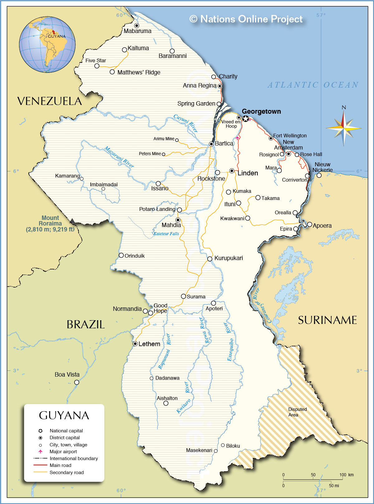
| Guyana is a country on the northeastern coast of South America. It is bordered by Disputed areas: the Courantyne River, forms a long part of the border with Suriname, which claims all the territories east of the river. More than half of the country is claimed by Venezuela (hatched area) which claims the western part of Guyana as far as the Essequibo River, the largest river in Guyana. The country is part of the Guianas, a region in north-eastern South America on the Guiana Shield, an old stable geological formation that forms a portion of the northern coast. The Guianas are bounded by the Orinoco, Negro, and Amazon rivers and the Atlantic Ocean. It includes Guyana, Suriname, and With an area of 214,969 km² Guyana is somewhat smaller than the United Kingdom, or slightly smaller than the U.S. state of Idaho. The population of Guyana are largely descendents from Asian laborers (Indo-Guyanese, 43%) and African slaves (Afro-Guyanese, 30%. Their ancestors were brought in to work on sugar plantations. There are 17% Guyanese of mixed heritage, and there is also left a small American Indian population (9%). The country has a population of today 748,000 people (Census 2012), 90% of the residents live in the coastal regions. Spoken languages are English and Guyanese Creole (lingua franca), and Caribbean Hindustani. Geography of Guyana Guyana's landscape offers a variety of natural regions, a narrow, fertile coastal plain dotted with marshes and cultivated land, a belt of white sand more inland in a hilly sand and clay region with rich mineral deposits. The interior consists mostly of rolling hills covered by tropical rainforest, and a series of plateaus, flat-topped mountains, and savannahs. The Rupununi Savannah, a desert and grassland savannah in south west, located between the Rupununi River and the border with Brazil and Venezuela. The Pacaraima Mountains in the western part of the interior highlands, with the country's highest peak, Mount Roraima (2,810 m; 9,220 ft). Map is showing the South American country with international borders, the national capital Georgetown, province capitals, major towns, villages, and resorts, main roads, secondary roads, the country's only international airport, Cheddi Jagan International Airport (IATA code: GEO) south of Georgetown. |
 Bookmark/share this page |
 One World - Nations Online All Countries of the World |
|
|
||
 Political Map of Guyana |
|||||||
| Cities and Towns in Guyana Map shows the location of following Guyanese cities, towns and villages: Aishalton, Anna Regina (capital of the Pomeroon-Supenaam Region), Apoteri, Arimu Mine, Baramanni, Bartica, Biloku, Charity, Corriverton (easternmost town in Guyana at the Corentyne River, opposite Nieuw Nickerie, Suriname, the towns are linked by ferry), Dadanawa, Epira, Five Star, Fort Wellington, Georgetown (capital and largest city; pop. 240,000), Good Hope, Imbaimadai, Issano, Kaituma, Kamarang, Kumaka, Kurupukari, Kwakwani, Lethem, Linden (second largest town; pop. 60,000), Mabaruma, Mahdia, Mara, Masekenari, Matthews’ Ridge, New Amsterdam (sea port and third largest town; pop. 30,000), Normandia, Orealla, Orinduik, Peters Mine, Potaro Landing, Rockstone, Rose Hall, Rosignol, Spring Garden, Surama, TakamaItuni, and Vreed en Hoop. |
More about Guyana: Cities: Country: Historically related Countries: Continent: |
Guyana Current Weather Conditions, weather station at the Cheddi Jagan International Airport near Timehri.
|
Related Consumer Information:
|
||||
| Maps of other Countries in South America: Argentina Map, Brazil Map, Bolivia Map, Chile Map, Colombia Map, Ecuador Map, French Guiana Map, Paraguay Map, Peru Map, Suriname Map, Uruguay Map, Venezuela Map Maps of other Countries in Central America: Costa Rica Map, El Salvador Map, Guatemala Map, Honduras Map, Mexico Map, Nicaragua Map Maps of Caribbean Islands: Cuba Map, Dominican Republic Map, Haiti Map, Jamaica Map, Puerto Rico Map | |||||||
One World - Nations Online .:. let's care for this planet Every nation is responsible for the current state of our world. |
| Site Map
| Information Sources | Disclaimer: Privacy Policy, etc. Contact: [email protected] | Copyright © 1998-2021 :: nationsonline.org |
