Nations Online
All Countries in the World
Nations Online All Countries in the World | |
Home  |
___ Satellite View of Ecuador |
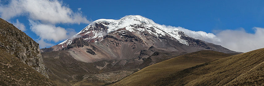 Chimborazo in the Cordillera Occidental range of the Andes is the highest mountain in Ecuador. Image: Bernard Gagnon |
About EcuadorMap is showing the north-western South American country bordering the Pacific Ocean in west. Countries with international borders to Ecuador are Colombia and Peru.Ecuador's area is somewhat smaller than that of Italy, or slightly smaller than the U.S. state of Nevada. The country's landscape is divided in three main regions: the coastal plain (costa), the inter-Andean central highlands (sierra), and the flat to rolling eastern jungle (oriente). Highest point in the country is the peak of Chimborazo, a currently inactive stratovolcano with a hight of 6,268 m (20,564 ft). The Galapagos Islands, the famous archipelago of volcanic islands is situated 926 km (575 mi) west of continental Ecuador, the islands are a province of Ecuador. Ecuador has a population of 16.3 million people (2015). Capital city is Quito, largest city is Guayaquil. Spoken languages are Spanish and Quechua (both official). The map shows Ecuador with cities, towns, expressways, main roads and streets. To find a location use the form below. |
|
| To find a location type: street or place, city, optional: state, country. |
Local Time Ecuador:
Tuesday-July-14 01:57
UTC/GMT -5 hours
|
|
φ Latitude, λ Longitude (of Map center; move the map to see coordinates): , |
||||||
| Google Maps: Searchable map/satellite view of Republic of Ecuador. Points of interest: Quito with El Panecillo, La Capilla del Hombre museum, the Church and Convent of St. Francis, the Church of the Society of Jesus, and Basílica del Voto Nacional. Cajas National Park, Cotopaxi National Park with Cotopaxi volcano, Podocarpus National Park, Tortuga Bay on Santa Cruz Island, Baltra Island, and Floreana Island, the Galápagos National Park. |
Bookmark/share this page |
|||||
| More about Ecuador: Cities: Country: Key statistic figures Ecuador. Continent: |
Current Weather Conditions Quito
|
Related Consumer Information:
|
||||
| Searchable Maps of other Countries in South America: Argentina, Brazil, Bolivia, Chile, Colombia, Ecuador, French Guiana Guyana, Paraguay, Peru, Suriname, Uruguay, Venezuela Maps of other Countries in South America: Argentina Map, Brazil Map, Bolivia Map, Chile Map, Colombia Map, Ecuador Map, French Guiana Map, Guyana Map, Paraguay Map, Peru Map, Suriname Map, Uruguay Map, Venezuela Map Countries and Territories of The Americas |
||||||
Map Help [ show ] |
||||||
One World - Nations Online .:. let's care for this planet Promote that every nation assumes responsibility for our world. Nations Online Project is made to improve cross-cultural understanding and global awareness. More signal - less NOISE |
| Site Map
| Information Sources | Disclaimer | Copyright © 1998-2024:: nationsonline.org |

