Nations Online
All Countries in the World
Nations Online All Countries in the World | |
Home  |
___ Satellite View and Map of Paraguay |
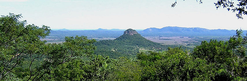 Mount Mbatovi (Cerro Mbatovi), within the Eco-reserva Mbatoví, a protected area and nature reserve located in the Paraguarí Department, Paraguay. - Image: Patricia Perez |
About ParaguayMap is showing Paraguay, the landlocked country in Central South America. The country is bordered by Argentina in south and south west, by Bolivia in north west, and by Brazil in east.Paraguay's area is slightly larger than 1.5 times the size of the United Kingdom or slightly smaller than the U.S. state of California. The Paraguay River divides the country into two different regions, Eastern Paraguay with grassy plains and wooded hills, known as the Paraná region; and Western Paraguay, a sparsely populated, hot and semi-arid lowland region with marshy plains near the river, and dry forest and thorny scrub elsewhere, the region is also known as the Paraguayan Chaco, part of the Gran Chaco, the lowland region of the Río de la Plata basin. The country has a population of 6.8 million people (official estimates 2014). Capital and largest city of Paraguay is Asunción, with its deep water port on the Paraguay River. Other major cities are Ciudad del Este, San Lorenzo, Luque, Capiatá, Lambaré, and Fernando de la Mora. Spoken languages are Spanish (official) and Guarani. The map shows Paraguay with cities, towns, expressways, main roads and streets. To find a location use the form below. |
|
| To find a location type: street or place, city, optional: state, country. |
Local Time Paraguay:
Tuesday-July-28 14:04
Time zone: Paraguay Time (PYT) UTC/GMT -4 hours |
|
φ Latitude, λ Longitude (of Map center; move the map to see coordinates): , |
||||||
| Google Maps: Searchable map/satellite view of Republic of Republic of Paraguay. Some Points of interest: Asunción with Museo del barro, National Pantheon of the Heroes and Casa de la Independencia Museum. Saltos del Monday, Cerro Cora National Park, National Park “Defensores del Chaco”, La Santísima Trinidad de Paraná. |
Bookmark/share this page |
|||||
| More about Paraguay: Cities: Country: Continent: |
Current Weather Conditions Asunción:
|
Related Consumer Information:
|
||||
| Searchable Maps of other Countries in South America: Argentina, Brazil, Bolivia, Chile, Colombia, Ecuador, French Guiana Guyana, Paraguay, Peru, Suriname, Uruguay, Venezuela Maps of other Countries in South America: Argentina Map, Brazil Map, Bolivia Map, Chile Map, Colombia Map, Ecuador Map, French Guiana Map, Guyana Map, Paraguay Map, Peru Map, Suriname Map, Uruguay Map, Venezuela Map Countries and Territories of The Americas |
||||||
Map Help [ show ] |
||||||
One World - Nations Online .:. let's care for this planet Promote that every nation assumes responsibility for our world. Nations Online Project is made to improve cross-cultural understanding and global awareness. More signal - less NOISE |
| Site Map
| Information Sources | Disclaimer | Copyright © 1998-2024:: nationsonline.org |

